Otego (town), New York facts for kids
Quick facts for kids
Otego, New York
|
|
|---|---|

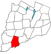
Otsego County map with the Town of Otego in red
|
|
| Country | United States |
| State | New York |
| County | Otsego |
| Area | |
| • Total | 45.71 sq mi (118.38 km2) |
| • Land | 45.63 sq mi (118.19 km2) |
| • Water | 0.08 sq mi (0.20 km2) |
| Elevation | 1,070 ft (330 m) |
| Population
(2010)
|
|
| • Total | 3,115 |
| • Estimate
(2016)
|
2,941 |
| • Density | 64.45/sq mi (24.88/km2) |
| Time zone | UTC-5 (Eastern (EST)) |
| • Summer (DST) | UTC-4 (EDT) |
| ZIP code |
13825
|
| Area code(s) | 607 |
| FIPS code | 36-077-55629 |
Otego is a town in the southwest part of Otsego County, New York, United States. In 2010, about 3,115 people lived there. The name "Otego" comes from a native word that means "where there is fire."
The Town of Otego is located on the southern edge of Otsego County. It includes a smaller area called the Village of Otego. Both the town and the village are southwest of the city of Oneonta.
Contents
History of Otego
People first started settling in the Otego area around 1775. However, not many more settlers arrived until after the American Revolution. Early growth was slow because of disagreements between German and New England settlers.
The Town of Otego was officially created in 1822. It was formed from parts of the Towns of Unadilla and Franklin. At first, it was called "Huntsville." In 1830, its name was changed to Otego. This happened when a part of the Town of Milford was added to it.
The Otsdawa Creek Site, an important historical place, was added to the National Register of Historic Places in 1980.
Notable People from Otego
- Helen E. Burbank was the Secretary of State of Vermont.
Geography of Otego
The town of Otego covers about 44.9 square miles (116.2 square kilometers) of land. There is no water area within the town's borders.
The southern edge of the town is also the border of Delaware County.
The Susquehanna River flows through the southern part of Otego. The Otego Creek joins the Susquehanna River just east of the town's eastern border. The Otsdawa Creek flows along the eastern side of Otego.
Major roads like Interstate 88 and New York State Route 7 follow the path of the Susquehanna River through the town.
Population Information
| Historical population | |||
|---|---|---|---|
| Census | Pop. | %± | |
| 1820 | 1,414 | — | |
| 1830 | 2,136 | 51.1% | |
| 1840 | 1,919 | −10.2% | |
| 1850 | 1,792 | −6.6% | |
| 1860 | 1,957 | 9.2% | |
| 1870 | 2,052 | 4.9% | |
| 1880 | 1,918 | −6.5% | |
| 1890 | 1,840 | −4.1% | |
| 1900 | 1,817 | −1.2% | |
| 1910 | 1,699 | −6.5% | |
| 1920 | 1,366 | −19.6% | |
| 1930 | 1,373 | 0.5% | |
| 1940 | 1,508 | 9.8% | |
| 1950 | 1,769 | 17.3% | |
| 1960 | 2,008 | 13.5% | |
| 1970 | 2,249 | 12.0% | |
| 1980 | 2,801 | 24.5% | |
| 1990 | 3,128 | 11.7% | |
| 2000 | 3,183 | 1.8% | |
| 2010 | 3,115 | −2.1% | |
| 2016 (est.) | 2,941 | −5.6% | |
| U.S. Decennial Census | |||
In 2000, there were 3,183 people living in Otego. These people lived in 1,234 households. About 33.8% of these households had children under 18 living with them.
The population was spread out by age. About 27% of the people were under 18 years old. Around 14.2% were 65 years or older. The average age in the town was 39 years.
Communities and Locations in Otego
- Calder Hill – This is a small mountain range north of Otego. It has two main peaks, with the highest being 1,841 feet tall. It was named after Godfrey Calder.
- Center Brook – This used to be a place in the town.
- Cooks Corners – This is a small community, also called a hamlet, in the northwest part of Otego. You can find it on County Highway 6.
- Hell Hollow – This area is also known as "The Perry District." A schoolteacher gave it this name because of how lively his students were.
- Lake Misery – This is a small lake located in the northwest part of the town.
- Mill Creek – This is a small community west of Hell Hollow and north of the Village of Otego. It's on a creek of the same name. This creek once powered many small mills.
- Mount Zion – This is a raised area southwest of Otego. Part of it is in Delaware County.
- Otego – This is the main Village of Otego, located on NY-7.
- Otsdawa – This is a hamlet in the northeast part of the town. It's on County Highway 8 and the West Branch Otsdawa Creek. The Otsdawa Baptist Church was added to the National Register of Historic Places in 2002.
See also
 In Spanish: Otego para niños
 | Jessica Watkins |
 | Robert Henry Lawrence Jr. |
 | Mae Jemison |
 | Sian Proctor |
 | Guion Bluford |

