New Hartford (village), New York facts for kids
- For other places with this name, see New Hartford (disambiguation).
Quick facts for kids
New Hartford, New York
|
|
|---|---|
|
Village
|
|

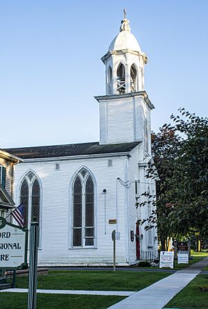
St. Stephen's Church in the village of New Hartford
|
|

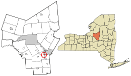
Location in Oneida County and the state of New York.
|
|
| Country | United States |
| State | New York |
| County | Oneida |
| Area | |
| • Total | 0.62 sq mi (1.60 km2) |
| • Land | 0.62 sq mi (1.60 km2) |
| • Water | 0.00 sq mi (0.00 km2) |
| Elevation | 541 ft (165 m) |
| Population
(2020)
|
|
| • Total | 1,859 |
| • Density | 3,003.23/sq mi (1,159.09/km2) |
| Time zone | UTC-5 (Eastern (EST)) |
| • Summer (DST) | UTC-4 (EDT) |
| ZIP code |
13413
|
| Area code(s) | 315 |
| FIPS code | 36-50298 |
| GNIS feature ID | 0958418 |
New Hartford is a small village in Oneida County, New York, USA. In 2020, about 1,859 people lived here. Early settlers from New Hartford, Connecticut gave the village its name. It is located within the larger Town of New Hartford. The village is also close to the city of Utica, New York.
Contents
History of New Hartford Village
New Hartford started in 1789. The Sanger family built the first log cabin here. They also built mills, which helped the village grow. New Hartford was a successful trading center for a while. However, when the Erie Canal opened, the nearby city of Utica gained a big advantage.
The village of New Hartford officially became a village in 1869.
New Hartford Fire Department
The village's Fire Department began in 1901. The New Hartford Fire Department (NHFD) protects the village from fires. They also provide emergency medical help. About 98 volunteer firefighters serve the community. This makes it the busiest volunteer fire department in Oneida County.
Historical Landmarks
Some houses along Oxford Road have a special history. They were used to hide enslaved people on the Underground Railroad. This was a secret network that helped people escape to freedom.
St. Stephen's Church is an important building. It was added to the National Register of Historic Places in 1996. This means it is a historically important place.
Geography of New Hartford
New Hartford is located at coordinates 43°4′9″N 75°17′18″W / 43.06917°N 75.28833°W. This helps pinpoint its exact spot on a map.
The United States Census Bureau says the village covers about 0.6 square miles. All of this area is land. There are no large bodies of water within the village limits.
Population and People
New Hartford has seen its population change over the years. Here is a look at how many people have lived in the village during different census years:
| Historical population | |||
|---|---|---|---|
| Census | Pop. | %± | |
| 1870 | 743 | — | |
| 1880 | 710 | −4.4% | |
| 1890 | 912 | 28.5% | |
| 1900 | 1,007 | 10.4% | |
| 1910 | 1,195 | 18.7% | |
| 1920 | 1,621 | 35.6% | |
| 1930 | 1,885 | 16.3% | |
| 1940 | 1,914 | 1.5% | |
| 1950 | 1,947 | 1.7% | |
| 1960 | 2,468 | 26.8% | |
| 1970 | 2,433 | −1.4% | |
| 1980 | 2,313 | −4.9% | |
| 1990 | 2,111 | −8.7% | |
| 2000 | 1,886 | −10.7% | |
| 2010 | 1,847 | −2.1% | |
| 2020 | 1,859 | 0.6% | |
| U.S. Decennial Census | |||
Population Details from 2000
In 2000, there were 1,886 people living in the village. These people made up 857 households. About 501 of these households were families. The village had about 3,087 people per square mile.
Most residents in 2000 were White (about 97%). There were also smaller groups of Black, Native American, and Asian people. About 0.8% of the population was Hispanic or Latino.
About 25% of households had children under 18. Nearly half of the households (47.5%) were married couples. About 22% of households had someone living alone who was 65 or older.
The average age of people in the village was 42 years old. About 22% of the population was under 18. About 22% was 65 years or older.
The average income for a household in 2000 was about $43,563. For families, the average income was about $56,406. A small number of families (3.2%) and people (5.7%) lived below the poverty line.
See also
 In Spanish: New Hartford (villa) para niños
 | Aurelia Browder |
 | Nannie Helen Burroughs |
 | Michelle Alexander |

