
Cazenovia, New York facts for kids
Quick facts for kids
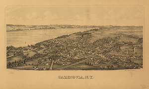
Cazenovia, New York
|
|
|---|---|

Downtown Cazenovia
|
|

Cazenovia, New York
Location in New York

Cazenovia, New York
Location in the United States
|
|
| Country | United States |
| State | New York |
| County | Madison |
| Area | |
| • Total | 51.79 sq mi (134.14 km2) |
| • Land | 49.94 sq mi (129.35 km2) |
| • Water | 1.85 sq mi (4.79 km2) |
| Population
(2020)
|
|
| • Total | 6,740 |
| • Density | 134.96/sq mi (52.11/km2) |
| Time zone | UTC-5 (EST) |
| • Summer (DST) | UTC-4 (EDT) |
| ZIP Codes | |
| Area code(s) | 315 |
| FIPS code | 36-053-13156 |
Cazenovia is a town in Madison County, New York. In 2020, about 6,740 people lived there. The town is named after Theophilus Cazenove, who was an important person from the Holland Land Company. The small village of Cazenovia is right in the middle of the town. The town is located on the western edge of Madison County.
The village of Cazenovia used to be home to Cazenovia College. This was a small college in the greater Syracuse area. It started in 1824 and was first known as the Genesee Seminary.
Contents
History of Cazenovia
The town of Cazenovia was created in 1793. It was formed from parts of two other towns, Whitestown and Paris. This happened before Madison County was even made. Later, other towns in the county were formed from parts of Cazenovia.
The town was started by John Lincklaen. He worked for the Holland Land Company. Cazenovia was named after Theophile Cazenove, who was Lincklaen's boss.
Geography of Cazenovia
The town is on the western side of Madison County. It shares a border with Onondaga County to the west. A main road, U.S. Route 20, goes through the town. This road leads east towards Albany and west towards Auburn.
Cazenovia covers about 51.79 square miles (134.14 square kilometers). Most of this area is land, but about 1.85 square miles (4.79 square kilometers) is water. Cazenovia Lake is a big lake in the middle-north part of the town. Water flows out of the south end of the lake, in Cazenovia village. This water forms Chittenango Creek. The creek flows north and eventually reaches Oneida Lake. From there, the water goes into the Oswego River and then into Lake Ontario.
Population of Cazenovia
| Historical population | |||
|---|---|---|---|
| Census | Pop. | %± | |
| 1820 | 3,909 | — | |
| 1830 | 4,344 | 11.1% | |
| 1840 | 4,153 | −4.4% | |
| 1850 | 4,812 | 15.9% | |
| 1860 | 4,343 | −9.7% | |
| 1870 | 4,265 | −1.8% | |
| 1880 | 4,363 | 2.3% | |
| 1890 | 4,182 | −4.1% | |
| 1900 | 3,830 | −8.4% | |
| 1910 | 3,687 | −3.7% | |
| 1920 | 3,343 | −9.3% | |
| 1930 | 3,504 | 4.8% | |
| 1940 | 3,424 | −2.3% | |
| 1950 | 3,969 | 15.9% | |
| 1960 | 4,968 | 25.2% | |
| 1970 | 6,092 | 22.6% | |
| 1980 | 5,880 | −3.5% | |
| 1990 | 6,514 | 10.8% | |
| 2000 | 6,481 | −0.5% | |
| 2010 | 7,086 | 9.3% | |
| 2020 | 6,740 | −4.9% | |
| U.S. Decennial Census | |||
In 2000, there were 6,481 people living in Cazenovia. There were 2,353 households, which are groups of people living together. About 32.3% of these households had children under 18. The average household had about 2.5 people.
The population included people of different ages. About 24% were under 18 years old. The median age was 39 years. This means half the people were younger than 39 and half were older.
Places in Cazenovia Town
Here are some of the communities and important spots in the town of Cazenovia:
- Abell Corners – A place east of Ballina.
- Ballina – A place south of Cazenovia village.
- Cazenovia – The main village, located on US-20 next to Cazenovia Lake.
- Cazenovia Lake – A lake next to Cazenovia village.
- Chittenango Falls – A place on the eastern border of the town, north of Cazenovia.
- Delphi Falls – A small community west-southwest of Union.
- Delphi Falls – A waterfall near the Delphi Falls community.
- Delphi Station – A place north of the New Woodstock community.
- Juddville – A place south of Abell Corners.
- New Woodstock – A community south of Cazenovia village.
- North Cazenovia – A place north of Cazenovia village.
- Perkins Corner – A place southwest of Rippleton on NY-13.
- Rippleton – A community southwest of Cazenovia village. It was once called "Pig City" in the 1800s.
- Union – A place west of Delphi Station.
- West Woodstock – A place west of New Woodstock.
Historic Places in Cazenovia
Cazenovia has many buildings and areas that are listed on the National Register of Historic Places. This means they are important for their history or architecture. One famous site is the Lorenzo State Historic Site, which is a historic house and estate.
| Name on the Register | Image | Date listed | Location | Neighborhood | Description | |
|---|---|---|---|---|---|---|
| 1 | Abell Farmhouse and Barn |
(#87001860) |
Ballina Rd. 42°54′11″N 75°49′31″W / 42.903056°N 75.825278°W |
|||
| 2 | Annas Farmhouse |
(#87001861) |
4812 Ridge Rd. 42°57′25″N 75°51′20″W / 42.956944°N 75.855556°W |
|||
| 3 | Beckwith Farmhouse |
(#87001862) |
4652 Syracuse Rd. 42°56′51″N 75°53′07″W / 42.9475°N 75.885278°W |
|||
| 4 | Cedar Cove |
(#91000867) |
W side of E. Lake Rd. 42°57′00″N 75°51′49″W / 42.95°N 75.863611°W |
|||
| 5 | Chappell Farmhouse |
(#87001864) |
Ridge Rd. 42°56′52″N 75°51′23″W / 42.947778°N 75.856389°W |
|||
| 6 | Cobblestone House |
(#87001865) |
Syracuse Rd. 42°56′35″N 75°52′59″W / 42.943056°N 75.883056°W |
|||
| 7 | Zephnia Comstock Farmhouse |
(#87001866) |
2363 Nelson St. 42°55′30″N 75°50′19″W / 42.925°N 75.838611°W |
|||
| 8 | Crandall Farm Complex |
(#87001867) |
2430 Ballina Rd. 42°53′35″N 75°50′13″W / 42.893056°N 75.836944°W |
|||
| 9 | Evergreen Acres |
(#87001868) |
Syracuse Rd. 42°55′38″N 75°52′38″W / 42.927222°N 75.877222°W |
|||
| 10 | Hillcrest |
(#91000869) |
Ridge Rd. S of Hoffman 42°56′20″N 75°51′27″W / 42.938889°N 75.8575°W |
|||
| 11 | Lorenzo |
 |
(#71000541) |
Ledyard St. (U.S. 20) 42°55′23″N 75°51′56″W / 42.923056°N 75.865556°W |
||
| 12 | The Maples |
(#87001876) |
2420 Nelson Rd. 42°55′19″N 75°50′08″W / 42.921944°N 75.835556°W |
|||
| 13 | Meadows Farm Complex |
(#87001869) |
Rippleton Rd. 42°55′01″N 75°51′40″W / 42.916944°N 75.861111°W |
|||
| 14 | Middle Farmhouse |
(#87001870) |
4875 W. Lake Rd. 42°57′29″N 75°52′58″W / 42.958056°N 75.882778°W |
|||
| 15 | Niles Farmhouse |
(#87001871) |
Rippleton Rd. 42°54′45″N 75°52′08″W / 42.9125°N 75.868889°W |
|||
| 16 | Notleymere |
(#91000868) |
4641 E. Lake Rd. 42°56′52″N 75°51′47″W / 42.947778°N 75.863056°W |
|||
| 17 | Old Trees |
(#91000865) |
W side of Rippleton Rd. 42°54′59″N 75°52′35″W / 42.916389°N 75.876389°W |
|||
| 18 | Ormonde |
(#91000866) |
Between E. Lake Rd. and Ormonde Dr. 42°57′20″N 75°51′41″W / 42.955556°N 75.861389°W |
|||
| 19 | Parker Farmhouse |
(#87001872) |
3981 East Rd. 42°54′58″N 75°51′04″W / 42.916111°N 75.851111°W |
|||
| 20 | Rippleton Schoolhouse |
(#98000996) |
Rippleton Rd., 15 mi. SE of Syracuse 42°55′16″N 75°51′46″W / 42.921111°N 75.862778°W |
|||
| 21 | Rolling Ridge Farm |
(#87001873) |
3937 Number Nine Rd. 42°54′46″N 75°50′45″W / 42.912778°N 75.845833°W |
|||
| 22 | Shattuck House |
(#91000873) |
W. Lake Rd. 42°58′16″N 75°53′04″W / 42.971111°N 75.884444°W |
|||
| 23 | Sweetland Farmhouse |
(#87001874) |
Number Nine Rd. 42°54′52″N 75°50′44″W / 42.914444°N 75.845556°W |
|||
| 24 | Tall Pines |
(#87001875) |
Ridge Rd. 42°57′03″N 75°51′23″W / 42.950833°N 75.856389°W |
|||
| 25 | The Hickories |
(#91000870) |
47 Forman St. 42°56′04″N 75°51′37″W / 42.934444°N 75.860278°W |
|||
| 26 | Upenough |
(#91000871) |
Rippleton St. 42°54′12″N 75°52′34″W / 42.903333°N 75.876111°W |
|||
| 27 | York Lodge |
(#91000872) |
4448 E. Lake Rd. 42°56′21″N 75°51′29″W / 42.939167°N 75.858056°W |
Famous People from Cazenovia
Many interesting people have connections to Cazenovia:
- Edward P. Allis (1824–1889) – A businessman.
- Edward Griffin Beckwith (1818–1881) – A soldier and explorer.
- Anne Burrell (born 1969) – A famous chef and TV personality.
- Samuel Northrup Castle (1808–1894) – A missionary and founder of Castle & Cooke.
- Sarah Brown Ingersoll Cooper – A kind person who helped with education.
- John W. Dwinelle (1816–1888) – A lawyer and politician.
- Harrison Stiles Fairchild (1820–1901) – A general in the Union Army.
- Siobhan Fallon (born 1961) – An actress.
- John Lincklaen (1768–1822) – The person who founded and developed Cazenovia.
- Beezie Madden (born 1963) – An Olympic gold medalist in horse riding.
- Lauren McLean – The mayor of Boise, Idaho. She grew up in Cazenovia.
- Charles Stebbins (1789–1873) – He was acting lieutenant governor of New York.
- Steve Suhey (1922–1977) – A football player.
- Ezra Greenleaf Weld (1801–1874) – A photographer and someone who worked to end slavery.
Economy
- Marquardt Group – This company has one of its main offices in Cazenovia.
Gallery
-

Lincklaen House

See also
 In Spanish: Cazenovia (Nueva York) para niños
