Wampsville, New York facts for kids
Quick facts for kids
Wampsville, New York
|
|
|---|---|
|
Village
|
|

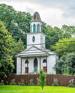
Wampsville Presbyterian Church
|
|
| Country | United States |
| State | New York |
| County | Madison |
| Area | |
| • Total | 1.03 sq mi (2.67 km2) |
| • Land | 1.02 sq mi (2.65 km2) |
| • Water | 0.01 sq mi (0.02 km2) |
| Elevation | 482 ft (147 m) |
| Population
(2020)
|
|
| • Total | 573 |
| • Density | 559.57/sq mi (216.00/km2) |
| Time zone | UTC-5 (Eastern (EST)) |
| • Summer (DST) | UTC-4 (EDT) |
| ZIP code |
13163
|
| Area code(s) | 315 |
| FIPS code | 36-78113 |
| GNIS feature ID | 0968750 |
Wampsville is a small village located in Madison County, New York, United States. It is part of the Town of Lenox. Wampsville is special because it is the "county seat" of Madison County. This means it's where the main government offices for the county are located.
In 2020, about 573 people lived in Wampsville. The village is in the northern part of Madison County. It is also close to the eastern edge of the Town of Lenox.
Contents
History of Wampsville
Wampsville was founded by a person named Johann Myndert Wemple. He lived from 1766 to 1837. The village was actually called Wempsville at first, named after him.
Why Wampsville Became the County Seat
Choosing a county seat can be tricky. Two nearby towns, Oneida and Canastota, both wanted to be the county seat. They could not agree on which town should have this important role.
To solve the problem, Wampsville was chosen instead. It was a neutral spot between the two towns. The county courthouse in Wampsville even faces north. This way, it does not seem to favor either Oneida or Canastota.
Where is Wampsville Located?
Wampsville is located at coordinates 43.081507 degrees North and -75.708041 degrees West.
The United States Census Bureau says that the village covers about 1.0 square mile (2.6 square kilometers) of land. There is no water area within the village limits.
People of Wampsville
| Historical population | |||
|---|---|---|---|
| Census | Pop. | %± | |
| 1910 | 212 | — | |
| 1920 | 276 | 30.2% | |
| 1930 | 280 | 1.4% | |
| 1940 | 282 | 0.7% | |
| 1950 | 379 | 34.4% | |
| 1960 | 564 | 48.8% | |
| 1970 | 586 | 3.9% | |
| 1980 | 569 | −2.9% | |
| 1990 | 501 | −12.0% | |
| 2000 | 561 | 12.0% | |
| 2010 | 543 | −3.2% | |
| 2020 | 573 | 5.5% | |
| U.S. Decennial Census | |||
In 2000, there were 561 people living in Wampsville. These people lived in 204 households. About 147 of these households were families. The village had about 554 people per square mile.
Most people in Wampsville were White (96.08%). A small number of people were from other racial backgrounds. About 1.60% of the population was Hispanic or Latino.
Households and Families
- 38.2% of households had children under 18 living with them.
- 60.8% were married couples living together.
- 8.8% had a female head of household with no husband present.
- 27.5% were not families.
- 20.1% of all households had only one person living there.
- 10.8% had someone living alone who was 65 years old or older.
The average household had 2.75 people. The average family had 3.22 people.
Age Distribution
The population of Wampsville was spread out by age:
- 31.6% were under 18 years old.
- 5.9% were between 18 and 24 years old.
- 30.8% were between 25 and 44 years old.
- 19.4% were between 45 and 64 years old.
- 12.3% were 65 years old or older.
The average age in the village was 35 years. For every 100 females, there were about 103 males.
Income Information
In 2000, the average income for a household in Wampsville was $39,063 per year. For families, the average income was $42,679 per year.
The average income per person in the village was $16,636. A small number of families (5.4%) and people (4.3%) lived below the poverty line. This included 3.7% of those under 18.
Famous People from Wampsville
- Milton De Lano: He was a US Congressman.
- Pierce Downer: He was the person who founded the town of Downers Grove in Illinois.
See also
 In Spanish: Wampsville para niños
 | Kyle Baker |
 | Joseph Yoakum |
 | Laura Wheeler Waring |
 | Henry Ossawa Tanner |


