
Wood Creek facts for kids
Quick facts for kids Wood Creek |
|
|---|---|

Looking upstream in June. Until 1820, canoes, batteaux, and 60-foot Durham boats would have passed many times each day.
|
|
 Midway along Wood Creek. The lighter colored area indicates the Oswego River watershed; Wood Creek's source is at the edge of this watershed.
|
|
| Native name | Ka-ne-go-dick |
| Country | United States |
| State | New York |
| Region | Oneida County, New York |
| Physical characteristics | |
| Main source | Delta Reservoir (since 1916) 43°16′55″N 75°27′04″W / 43.28194°N 75.45111°W |
| River mouth | Oneida Lake Sylvan Beach 43°12′12″N 75°41′35″W / 43.20333°N 75.69306°W |

Wood Creek is a small but very important river in Central New York State. It flows west from the city of Rome, New York into Oneida Lake. From there, its waters eventually reach Lake Ontario, which is one of the five Great Lakes.
Even though Wood Creek is less than 20 miles (32 km) long, it played a huge role in history. For many years in the 1700s and early 1800s, it was a vital part of a major waterway. This waterway connected the Atlantic Ocean to the vast lands beyond the Appalachian Mountains.
The route started from the Hudson River (near Albany, New York) and went along the Mohawk River. Near what is now Rome, New York, boats and cargo had to be carried overland for about a mile to reach Wood Creek. This spot was called the "Oneida Carry".
In 1797, the Rome Canal was built, creating a continuous water path. After that, boats traveled down Wood Creek to the east end of Oneida Lake. They then crossed the lake and entered the Oswego River system. This system led either to Lake Ontario at Oswego or further west along the Seneca River. This Mohawk River route was incredibly important for over a century.
Contents
Why Was Wood Creek So Important?
Wood Creek and the Oneida Carry were super important because they were one of the only ways to get from the Atlantic coast into the North American interior by water. The only other major water route across the Appalachian Mountains was the St. Lawrence River far to the north in Canada.
Philip Lord, Jr., a researcher from the New York State Museum, has studied this Albany-Oswego waterway and Wood Creek a lot. His work shows just how vital this small river was for travel and trade.
Battles and Forts: Wood Creek in the 1700s
In the 1700s, boats coming up the Mohawk River had to be moved overland at the Oneida Carry to reach Wood Creek. From there, they floated downstream to Oneida Lake and the Oswego River. Native Americans used this route with their canoes for a long time. In 1702, leaders of The Five Nations asked the British governor to mark the Carry and clear Wood Creek.
- Early Improvements: Besides clearing the creek, a short canal was built in 1730 to bypass a tricky bend in the Mohawk River. This was one of the first canals ever built in North America!
Wood Creek During Wars
Wood Creek and the Oneida Carry were so important that the British built forts there during their war with France (the French and Indian War from 1754–1763).
- Fort Bull: This fort was on Wood Creek and was attacked in 1756 during the Battle of Fort Bull. After it was destroyed, a new fort called Fort Wood Creek was built briefly.
- Fort Stanwix: In 1758, a huge fort called Fort Stanwix was built to protect the Oneida Carry. It didn't see much action then and was later left empty.
During the American Revolutionary War, American forces fixed up Fort Stanwix in 1777. It became the site of an important battle that year. British and other forces came down from Canada and up Wood Creek to attack the fort. They failed, which helped lead to the British defeat at the Battles of Saratoga soon after. This failure was a major turning point in the American Revolution.
After the American Revolutionary War, a company called the Western Inland Lock Navigation Company was started in New York State in 1791. Their goal was to improve the Albany-Oswego waterway.
Philip Lord wrote that this difficult route was the only major "highway" to the west 200 years ago. The company's job was to make it easier to travel from Schenectady to Oneida Lake. By 1803, their improvements had greatly increased shipping and lowered costs. More and more settlers were moving to western New York, and this waterway helped them get there.
Challenges and Clever Solutions on Wood Creek
Wood Creek was the trickiest part of the waterway. It was narrow and winding, connecting the Rome Canal to Oneida Lake. Travelers often said they could jump across it! Sometimes, there wasn't enough water, and boatmen had to ask a nearby miller to release water from his pond to float their boats.
Despite these problems, Wood Creek was the "lynchpin" (the most important part) of the route to the Great Lakes.
- Cutting Through Bends: In 1793, 13 short canals were dug to bypass the winding bends, or "hooks," in the creek. These were some of the earliest man-made waterways for boats in North America.
- Covered Locks: In 1802, four wooden locks were built to help boats move between the Rome Canal and Canada Creek. These locks were unusual because they were "covered," like many bridges in the 1800s.
- "Brushpiling" Technique: Researchers Philip Lord and Chris Salisbury found that a man named Abraham Ogden used a clever method called "brushpiling" or a "kid weir" to improve navigation on Wood Creek in 1803. This was an ancient English technique for controlling erosion and improving waterways, and its use on Wood Creek was the first time it was applied in the United States.
The Oneida Carry was replaced by the Rome Canal in 1797. By 1803, all the improvements by the Western Inland Lock Navigation Company were finished. This allowed larger boats, called batteaux, to be replaced by even heavier boats.
The Erie Canal's Arrival

The improvements made by the Western Inland Lock Navigation Company were a big step. They allowed new Durham boats, up to 60 feet long and carrying 16 tons, to replace smaller boats that only carried about one and a half tons.
This greatly reduced the cost of shipping goods. For example, the cost to transport one ton of cargo from Albany to Seneca Lake dropped from $100 to $32. Furs, lumber, wheat, and salt came down the canals, while European goods went up. In 1812, about 1500 tons of cargo moved through Rome using this route.
Even though the navigation was not perfect compared to what came later, it was incredibly important for the early growth and settlement of western New York. Many workers learned how to build canals, and engineers gained valuable experience.
These experiences helped lead to an even bigger project: the Erie Canal.
The End of Wood Creek's Era
In 1817, New York State decided to build the Erie Canal. This massive project would solve all the problems of the old Albany-Oswego waterway. It was a huge, complex system unlike anything built before.
In 1820, the state bought the works of the Western Inland Lock Navigation Company. The Erie Canal bypassed the Wood Creek to Oswego part of the old waterway. Instead, it went directly from Rome through Syracuse and Rochester to Buffalo, on Lake Erie.
The Rome Canal and the waterway along Wood Creek to Oneida Lake were no longer used. The century when tiny Wood Creek was a main channel for cargo between the American interior and the Atlantic Ocean had come to an end.
Images for kids
-
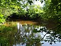
Looking upstream in June. Until 1820, canoes, batteaux, and 60-foot Durham boats would have passed many times each day.
-
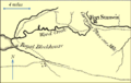
A map from 1772 showing the important waterway connecting the Hudson River and Lake Ontario. This part shows Wood Creek, which was a key link. The "Carrying Place" was where boats had to be moved overland.
-
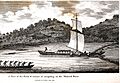
A Durham boat with sails traveling on the Mohawk River in 1807. It's passing through a V-shaped rock dam, similar to Native American fishing traps.
