Glacial Lake Iroquois facts for kids
Quick facts for kids Lake Iroquois |
|
|---|---|

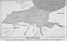
This map shows the valley of the Mohawk River, through which Glacial Lake Iroquois crossed the mountains to the Hudson River Valley.
|
|
| Location | North America |
| Group | Great Lakes |
| Coordinates | 43°42′N 77°54′W / 43.7°N 77.9°W |
| Lake type | former lake |
| Etymology | Iroquois or Haudenosaunee (/ˈhoʊdənoʊˈshōni/; "People of the Longhouse") |
| Primary inflows | Niagara River Welland Canal |
| Primary outflows | Mohawk River to the Hudson River |
| Basin countries | Canada United States |
| Max. length | 196 mi (315 km) |
| Max. width | 57 mi (92 km) |
| Surface elevation | 345 ft (105 m) |
Glacial Lake Iroquois was a huge ancient lake. It existed about 13,000 years ago, at the end of the last ice age. This was a time when large parts of the Earth were covered in thick ice sheets.
Lake Iroquois was much larger than today's Lake Ontario. It formed because a giant ice sheet blocked the St. Lawrence River. This river usually drains Lake Ontario. With the river blocked, water built up, creating a much bigger lake.
The water level of Lake Iroquois was about 30 meters (100 feet) higher than Lake Ontario is today. It drained towards the southeast, flowing through what is now New York. The water then followed the Mohawk River valley to the Hudson River.
Contents
How Lake Iroquois Formed
During the last ice age, a massive sheet of ice covered much of North America. As this ice slowly melted, it created many large lakes. Lake Iroquois was one of these "proglacial lakes." This means it formed right at the edge of a melting glacier.
The ice sheet acted like a giant dam. It blocked the natural path of water from the Great Lakes region towards the Atlantic Ocean. Specifically, the ice blocked the Saint Lawrence River near the Thousand Islands. This caused water to back up, forming Lake Iroquois.
Water Sources for the Ancient Lake
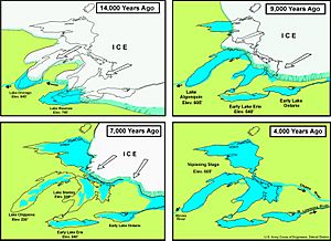
Lake Iroquois received water from several sources. One main source was Early Lake Erie, which was an older version of today's Lake Erie.
It also got water from Glacial Lake Algonquin. This was an early version of Lake Huron. Lake Algonquin's water flowed directly into Lake Iroquois. It traveled across southern Ontario, along the edge of the ice sheet. This path allowed it to bypass Early Lake Erie.
The End of Lake Iroquois
Eventually, the huge ice dam that held back Lake Iroquois began to melt completely. When this ice dam broke, the lake's water level dropped very quickly. It fell to about the same level as today's Lake Ontario.
This sudden drop in water levels might have caused a big change in the climate. Some scientists think it could have helped trigger an event called the Younger Dryas. This was a period when temperatures in the Northern Hemisphere suddenly became much colder again.
Traces of the Ancient Shoreline
Even though Lake Iroquois is gone, you can still find signs of where its shores used to be. These old shorelines are like ancient beaches or cliffs.
Shorelines in Toronto
In the Toronto area, you can see two old shorelines. About 2 kilometers (1.2 miles) inland from the current lake, there's a ridge. This ridge is known as the Iroquois Shoreline. It runs from west to east, roughly parallel to Davenport Road. You can find it just south of St. Clair Avenue West.
Further east, the Scarborough Bluffs were also part of this ancient lake's shoreline. In Mississauga, the shoreline is south of Dundas Street. You can see it best as hills east and west of Mavis Road.
Underwater Shorelines
Another ancient shoreline exists underwater, about 2 to 4 kilometers (1.2 to 2.5 miles) offshore of Toronto. This is called the Toronto Scarp. It was the shore of an even older lake, either Glacial Lake Warren or Admiralty Lake. This underwater cliff stretches from Bluffer's Park in Scarborough to west of Hanlan's Point.
Shorelines in New York
In New York, you can also find traces of Lake Iroquois. Ridge Road and New York State Route 104 follow a ridge. This ridge runs from west to east and marks the old shoreline of Lake Iroquois.
 | Aurelia Browder |
 | Nannie Helen Burroughs |
 | Michelle Alexander |


