Lake Algonquin facts for kids
Quick facts for kids Lake Algonquin |
|
|---|---|

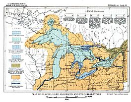
Map of Glacial Lake Algonquin and its Correlatives (USGS)
|
|
| Lua error in Module:Location_map at line 420: attempt to index field 'wikibase' (a nil value). | |
| Location | North America |
| Group | Great Lakes |
| Lake type | former lake |
| Etymology | Algonquin people |
| Primary inflows | Laurentide Glacier |
| Primary outflows | St. Clair River |
| Basin countries | Canada United States |
| First flooded | 11,000 years before present |
| Max. length | 586 mi (943 km) |
| Max. width | 591 mi (951 km) |
| Residence time | 3000 years in existence |
| Surface elevation | 295 ft (90 m) |
Lake Algonquin was a huge ancient lake in North America. It existed during the last ice age, many thousands of years ago. This giant lake was much bigger than today's Great Lakes. Over time, parts of Lake Algonquin became the lakes we know today. These include Lake Huron, Lake Superior, and Lake Michigan. It also formed Georgian Bay, Lake Nipigon, and Lake Nipissing.
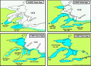
Lake Algonquin changed size a lot. It was largest right after the glaciers started melting. Eventually, it shrunk down to become Lake Huron and Georgian Bay. Around 7,000 years ago, as the glaciers kept melting, Lake Algonquin split. It became two smaller lakes, Lake Chippewa and Lake Stanley. About 3,000 years after that, it changed again. It formed the current Lakes Michigan, Huron, and Superior.
Contents
How Lake Algonquin Formed
About 11,000 years ago, a huge ice sheet called the Laurentide Glacier started melting. As it melted, it moved northward. This created a natural boundary across the northern parts of Lake Superior and Lake Huron. The melting ice filled the land with water. This formed one giant body of water. It covered the areas of Lake Michigan, Lake Huron, and Lake Superior.
The water level of this massive lake was about 605 feet (184 meters) above sea level. This huge lake had three main ways for its water to flow out. These outlets were the Chicago Outlet River, the St. Clair-Detroit River, and the Trent Valley.
Stages of Lake Algonquin
Lake Algonquin didn't just appear all at once. It formed in different stages. Each stage depended on how much the glaciers had melted. The lake changed its size and where its water flowed out.
Early Lake Algonquin
The first stage of Lake Algonquin was smaller. It only covered the southern part of the Lake Huron area. This included a section called Saginaw Bay. Water from smaller lakes in the Georgian Bay and Lake Simcoe areas also flowed into it. This early lake drained through the St. Clair River at Port Huron, Michigan. From there, the water flowed into an early version of Lake Erie.
At this time, Lake Chicago existed in the southern part of Lake Michigan. Also, Lake Duluth was in the western tip of the Lake Superior area. Lake Chicago's water flowed across central Michigan. It then joined this early Lake Algonquin.
Main Lake Algonquin
As the glaciers continued to melt and move north, Lake Algonquin grew much larger. When the ice retreated north of Alpena, Michigan, the waters of Lake Chicago joined with Early Lake Algonquin. The two lakes were at nearly the same level. They kept their original outlets. The Port Huron outlet was in the southeast. The Chicago outlet was in the southwest.
The main phase of Lake Algonquin was huge. It covered both the Lake Michigan and Lake Huron areas. It even overflowed into low lands in Michigan's Upper Peninsula. The water levels kept changing. Four different water levels lasted long enough to create noticeable ancient beaches. These are called the Main Algonquin, Lower Algonquin, Battlefield, and Fort Brady beach levels.
Around 10,500 years ago, the lake found a new, lower way to drain. This new outlet was across the front of the glacier. It created the North Bay Outlet. Water flowed in the opposite direction of today's French River. It then went into an ancient version of the Ottawa River. As the water levels dropped, the Lake Michigan and Lake Huron areas separated. They became individual lakes. These were the Lake Chippewa low phase in the Michigan Basin and the Lake Stanley low phase in the Huron Basin.
 | William M. Jackson |
 | Juan E. Gilbert |
 | Neil deGrasse Tyson |


