French River (Ontario) facts for kids
Quick facts for kids French River |
|
|---|---|

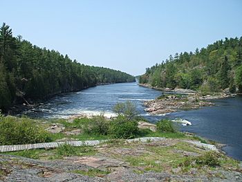
Recollet Falls of the French River near Hwy. 69
|
|
|
Location of the mouth of the French River in Ontario
|
|
| Other name(s) | Rivière des Français, Wemitigoj-Sibi |
| Country | Canada |
| Province | Ontario |
| Districts |
|
| Physical characteristics | |
| Main source | Lake Nipissing Nipissing District 46°12′30″N 79°49′30″W / 46.20833°N 79.82500°W |
| River mouth | Georgian Bay Parry Sound District Coords for Main Outlet: 45°56′26″N 80°54′06″W / 45.94056°N 80.90167°W |
| Length | 110 km (68 mi) |
| Basin features | |
| Basin size | 19,100 km2 (7,400 sq mi) |
The French River is a beautiful river in Central Ontario, Canada. It flows for about 110 kilometers (68 miles) from Lake Nipissing all the way west to Georgian Bay. This river often marks the border between Northern and Southern Ontario. In 1986, the French River was named a Canadian Heritage River. This means it is special for its history, nature, or recreation.
Contents
Exploring the French River's Geography
The French River flows through an area called the Canadian Shield. Here, you can see rugged, glaciated rock that was shaped by ancient glaciers. There are also many forests, especially along the upper parts of the river.
Near where the river meets Georgian Bay, you'll find countless islands. The river splits into many channels. Some parts are narrow gorges with steep walls, waterfalls, and rapids. Other parts open up into wide, calm waters.
Rivers that Flow into the French River
Many smaller rivers join the French River. These are called its tributaries. They include:
- Wanapitei River
- Pillow River
- Murdock River
- Wolseley River
- Little French River
- Pickerel River
- Restoule River
- Hall River
A Look at the French River's History
The French River was an important travel route for the Algonquian peoples who lived in this area long ago. The Ojibwe people called it Wemitigoj-Sibi.
Europeans started calling it the "French River" because French explorers used it in the 1600s. Famous explorers like Étienne Brûlé, Samuel de Champlain, and Pierre-Esprit Radisson traveled here. Missionaries also used this route.
Later, other famous explorers like Simon Fraser and Alexander Mackenzie followed this same path.
The French River and the Fur Trade
The French River was a key part of a "water highway" for the fur trade. This route connected Montreal to Lake Superior. It was used by canoes until about 1820.
Around 1855, a railway called the Grand Trunk Railway of Canada made it easier to reach the area. This led to more people exploring the French River. They came for fishing and logging. After a big fire in Chicago in 1871, there was a huge demand for wood. The French River had lots of trees, making it a perfect spot for logging.
By the late 1800s, logging was the main activity. Later, people started settling here for summer vacations and recreation. Because of its wild beauty, the French River is still popular for outdoor activities. These include canoeing, kayaking, photography, camping, fishing, and boating.
To protect the fish, the Ontario Ministry of Natural Resources put rules in place in 1994. These rules help make sure there are enough fish for the future.
French River Waterway Provincial Park
| French River Provincial Park | |
|---|---|
|
IUCN Category II (National Park)
|
|
| Location | Ontario, Canada |
| Nearest city | French River Noëlville |
| Area | 517.40 km2 (199.77 sq mi) |
| Established | 1989 |
| Governing body | Ontario Parks |
Most of the land along the French River is protected as a provincial park. This park stretches from Lake Nipissing to Georgian Bay. The only parts not in the park are lands belonging to the Dokis First Nation.
In the park, there are 230 undeveloped campsites. These are perfect for people who want to camp in the wilderness. The French River continues to attract visitors and cottage owners. They love its clear water, rocky shores, and pine forests.
 | Percy Lavon Julian |
 | Katherine Johnson |
 | George Washington Carver |
 | Annie Easley |


