Restoule River facts for kids
Quick facts for kids Restoule River |
|
|---|---|

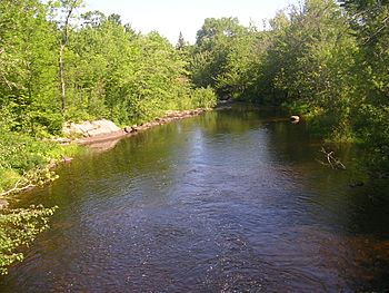
Restoule River looking north from Hawthorne Drive in the community of Restoule
|
|
|
Location of the mouth of the Restoule River in Ontario
|
|
| Country | Canada |
| Province | Ontario |
| Region | Central Ontario |
| District | Parry Sound |
| Physical characteristics | |
| Main source | Commanda Lake Restoule, Patterson Township 222 m (728 ft) 46°01′36″N 79°43′12″W / 46.02667°N 79.72000°W |
| River mouth | French River Hardy Township 187 m (614 ft) 46°06′29″N 80°01′03″W / 46.10806°N 80.01750°W |
| Length | 40 km (25 mi) |
| Basin features | |
| River system | Lake Huron drainage basin |
The Restoule River is a beautiful river in Ontario, Canada. It flows through the Parry Sound District in Central Ontario. This river starts at a lake called Commanda Lake in the small community of Restoule.
From its start, the Restoule River flows north into Restoule Lake. It then continues north into Stormy Lake, which is part of Restoule Provincial Park. You can find this park at the very end of Ontario Highway 534. After leaving the park, the river turns west. It flows through Hardy Township until it reaches its end at the French River.
The Restoule River is about 40 kilometres (20 mi) long. For part of its journey, from Lennon Lake to where it joins the French River, the Restoule River forms a border. This border is for the Dokis 9 reserve, which is a special area belonging to the Dokis First Nation people.
River Friends: Tributaries
Rivers often have smaller streams or rivers that flow into them. These are called tributaries. They add more water to the main river, making it bigger and stronger. The Restoule River has a few tributaries that join it along its path.
- Portage Creek (joins from the left side)
- Burnt Lake Creek (joins from the right side)
 | Delilah Pierce |
 | Gordon Parks |
 | Augusta Savage |
 | Charles Ethan Porter |


