Lake Chippewa facts for kids
Quick facts for kids Lake Chippewa |
|
|---|---|

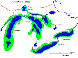
Glacial Lakes Chippewa, Stanley, Early Erie and Early Ontario. Low level lake stages during the end of the Wisconsin Glacial era in North America. Based on Larsen map, 1987.
|
|
| Lua error in Module:Location_map at line 420: attempt to index field 'wikibase' (a nil value). | |
| Location | North America |
| Group | Great Lakes |
| Lake type | former lake |
| Etymology | Chippewa People |
| Primary inflows | Laurentide Ice Sheet |
| Primary outflows | Grand River valley in Michigan |
| Basin countries | Canada United States |
| First flooded | 9,500 years before present |
| Max. length | 220 mi (350 km) |
| Max. width | 30 mi (48 km) |
| Residence time | 7300 years in existence |
| Surface elevation | 230 ft (70 m) |
Lake Chippewa was a huge, ancient lake that existed a very long time ago. It's called a proglacial lake because it formed near the edge of a giant ice sheet. Today, the area where Lake Chippewa once was is now the bottom of Lake Michigan.
This ancient lake started to form around 10,600 years ago. It filled a large dip in the land that was left behind by the melting Michigan Lobe of the Laurentide Ice Sheet. This ice sheet was a massive glacier that covered much of North America.
How Lake Chippewa Formed
Lake Chippewa began when another large glacial lake, called Lake Algonquin, started to shrink. As the water levels dropped, Lake Chippewa filled only the deepest parts of what is now the Lake Michigan basin.
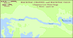
The water from Lake Chippewa flowed out through a narrow passage called the Straits of Mackinac. From there, it went into another ancient lake, Lake Stanley. The water then continued its journey. It either flowed into Lake Hough and then into the St. Lawrence River through the Ottawa River valley, or it went through the St. Clair and Detroit rivers into an early version of Early Lake Erie. From there, it flowed out through the Niagara River towards the St. Lawrence.
Around 10,300 years ago, Lake Chippewa's water levels dropped even more. For a while, it became a lake with no outlet, meaning water couldn't flow out of it. But then, the water levels rose again. Lake Chippewa once more flowed through the canyon at Mackinac. This continued until about 7,500 years ago. At that time, a group of lakes called the Nipissing Great Lakes joined with the waters in the Michigan Basin. This created one huge lake that covered all three of the upper Great Lakes as we know them today.
How Big Was It?
Lake Chippewa was a bit smaller than today's Lake Michigan. It stretched across most of the Michigan Basin. To the north, it reached the Straits of Mackinac. Here, there was a narrow channel where the lake's water flowed out. This water poured over what are now called the Mackinac Falls, which are currently underwater. The water then continued into Lake Stanley.
The shoreline of Lake Chippewa was quite far from where Lake Michigan's shore is today. It was about 10 to 30 miles (16 to 48 kilometers) further out into the lake.
 | Jewel Prestage |
 | Ella Baker |
 | Fannie Lou Hamer |


