Nipissing Great Lakes facts for kids
Quick facts for kids Nipissing Great Lakes |
|
|---|---|

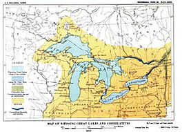
Map of Nipissing Great Lakes from the U.S. Geological Survey monograph of 1915.
|
|
| Location | North America |
| Group | Great Lakes |
| Coordinates | 45°48′N 84°43′W / 45.8°N 84.72°W |
| Lake type | former lake |
| Primary inflows | Laurentide Ice Sheet |
| Primary outflows | Ottawa River to the Mattawa River |
| Basin countries | Canada United States |
| First flooded | 7,500 years before present |
| Max. length | 241 mi (388 km) |
| Max. width | 200 mi (320 km) to 300 mi (480 km) |
| Max. depth | 595 mi (958 km) to 597 mi (961 km) |
| Surface elevation | 580 mi (930 km) |
The Nipissing Great Lakes was a huge ancient proglacial lake. This means it was a lake formed by melting glaciers. It covered parts of what are now Lake Superior, Lake Huron, Georgian Bay, and Lake Michigan.
This giant lake formed about 7,500 years ago. It filled the large dip in the land left behind by the melting Laurentide Ice Sheet. At first, the water flowed eastward from Georgian Bay into the Ottawa River valley. Over time, the land slowly rose in a process called isostatic rebound. This change in land height eventually opened a new path for the water through the St. Clair River valley.
Contents
How the Nipissing Great Lakes Formed
The Nipissing Great Lakes came to be when several smaller glacial lakes joined together. These included Glacial Lakes Houghton, Chippewa, Hough, and Stanley. As the water levels rose, these separate lakes merged.
Around 7,500 years ago, the water in the Michigan, Huron, and Superior basins became one huge lake. This single body of water covered all three of the upper Great Lakes. Areas like the lowlands near Sault Ste. Marie and across the Upper Peninsula of Michigan were completely underwater.
Where Was This Giant Lake?
The name "Nipissing Great Lakes" refers to the waters of the upper three Great Lakes during this ancient time. The glacier had completely melted away from the Great Lakes area. We use the plural "Lakes" because each basin was still a separate part, even though they were connected by narrow channels.
All these basins were at the same water level, making them appear as one big lake. For example, Lake Michigan was connected to Lake Huron by the Mackinac strait. The water here was about 50 feet (15 m) higher than it is today. There was also a smaller, shallower channel from Little Traverse Bay to the Huron basin. However, the main way the water flowed out of these lakes was eastward from the northeast part of Georgian Bay.
How the Water Drained Out
The main exit point for the Nipissing Great Lakes was the North Bay Outlet. This was located near North Bay, Ontario, where Lake Nipissing is today. As the land continued to rise from the glacier's weight, the Port Huron outlet eventually started to receive water again. This created a period where the lake had two main outlets.
The First Outlet: Ottawa and Mattawa Rivers
The North Bay outlet river, sometimes called the "Nipissing-Mattawa River," was about 580 feet (180 m) above sea level. It flowed over hard rock, mostly gneiss, eventually reaching the Mattawa River. The Mattawa River then joined the Ottawa River at Mattawa. From there, the water flowed out to the St. Lawrence River and into the ocean.
The Mattawa River is actually a series of lakes. Some of these lakes are long, narrow, and deep, sitting in canyon-like valleys. These valleys can be 200 feet (61 m) to 300 feet (91 m) wide, with water 100 feet (30 m) to 300 feet (91 m) deep. The canyon walls themselves can be 100 feet (30 m) or more high. Some spots along this route show signs of powerful water flow, similar to the St. Clair River today.
The Second Outlet: Detroit and Port Huron
During the later part of the two-outlet stage, a small amount of water also flowed through the Illinois River near Chicago. The land there is only about 8 feet (2.4 m) above the modern lake level. This small flow likely stopped once the Port Huron outlet had cut down a few feet.
Ancient Shorelines: The Beaches
Many of the low-water beaches from this time were later covered by water as the land rose. So, most of the known beaches of the Nipissing Great Lakes are those formed when the St. Clair valley was the main outlet. Only a few older beaches still exist.
The Niagara Gorge also shows signs of the Nipissing Great Lakes. A part of the gorge near the whirlpool has a shallow cut. This was made by a weaker waterfall when Lake Erie was the main source of water. Closer to the present-day waterfall, a much deeper cut begins. This deeper part seems to have been created after the Nipissing Great Lakes' water started flowing into the St. Clair outlet, sending more water to Lake Erie. Scientists estimate it took between 2,700 and 3,500 years to carve this deep part of the gorge.
Since the St. Clair outlet opened, water has flowed continuously in the same direction. The outlet has deepened slightly, lowering the lake level by about 14 feet (4.3 m). The ancient beach at 596 feet (182 m) in the southern Huron basin was used by both Lake Nipissing and a later stage of Lake Algonquin. This means the lake level dropped from that height to its current level. Today, the beach is about 582 feet (177 m) to 584 feet (178 m) high, with the average water level around 580 feet (180 m).
What is the Nipissing Beach?
The term "Nipissing beach" was first used for the shoreline formed during the time when the lakes had two outlets. More accurately, it refers to the older beach created by the Nipissing Great Lakes when all the water flowed through the Ottawa River.
After the true Nipissing beach formed, the land continued to rise due to isostatic rebound. This caused the water level to drop on the north side of the basin and rise on the south side. Because of this, the older Nipissing beach in the south was flooded and destroyed. Only in the northeast corner of Lake Superior can you still find parts of this original Nipissing beach.
South of a certain "hinge line" (where the land didn't tilt), the Nipissing beaches are flat. They are about 14 and 16 feet (4.3 and 4.9 m) above the current lake level, with an average of 15 feet (4.6 m). In the south, it can be hard to tell the Nipissing beach apart from the Lake Algonquin beach. Both are about 10 and 12 feet (3.0 and 3.7 m) below the highest Algonquin beach.
Other Lakes Affected by Nipissing Great Lakes
Lake St. Clair
During the time of the Nipissing Great Lakes, Lake St. Clair was very low. It was almost completely gone as a lake. Only a slow, small stream with some expanded ponds or swampy areas remained.
Lake Erie
Lake Erie also had very low water levels during the Nipissing Great Lakes period. Without the large amount of water flowing in from the upper lakes, Lake Erie and Niagara Falls would not have had enough water to carve out the deep channel we see today. Lake Erie was a non-glacial lake at this time. The huge amount of water from the upper lakes was instead flowing through the North Bay outlet in Ontario. During this low stage, Lake Erie was about 10 feet (3.0 m) to 12 feet (3.7 m) lower than its current level. This low level lasted throughout the time of the Nipissing Great Lakes.
Champlain Sea
The Champlain Sea was a temporary inlet of the Atlantic Ocean that existed in parts of what is now Quebec and Ontario. It had mostly disappeared by the time the Nipissing Great Lakes formed. Most of the land uplift in that area had already happened. A well-developed shoreline, called the Micmac beach, stretches for 200 miles (320 km) below Quebec along the south side of the lower St. Lawrence. It is about 20 feet (6.1 m) above the level of the Gulf of St. Lawrence and is flat. The waves at this level were very powerful for a long time, cutting sea cliffs up to 100 feet (30 m) high in some places.
 | Ernest Everett Just |
 | Mary Jackson |
 | Emmett Chappelle |
 | Marie Maynard Daly |


