Scarborough Bluffs facts for kids
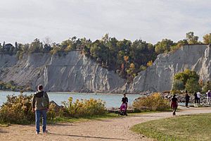
The Scarborough Bluffs, often called The Bluffs, are amazing cliffs in the Scarborough area of Toronto, Ontario, Canada. They are like a giant wall of land that rises high above the shore of Lake Ontario. These bluffs form a big part of Toronto's eastern waterfront. At their highest point, they reach about 90 meters (300 feet) tall. That's as tall as a 25-story building! The Bluffs stretch for about 15 kilometers (9 miles) along the lake.
There are nine parks located along the Bluffs. Bluffer's Park is special because it's the only one with a sandy beach right at the bottom of the cliffs.
Contents
History of the Bluffs
Long ago, French explorers called these cliffs "Les Grands Ecores," meaning "tall points on the shore." In 1788, a map simply called them the "High Lands."
The name "Scarborough Highlands" came in 1793. This name was chosen by Elizabeth Simcoe. She was the wife of the first governor of Upper Canada, John Graves Simcoe. The cliffs reminded Elizabeth Simcoe of the white limestone cliffs in her hometown in England, called Scarborough.
She wrote in her diary that the shore looked like "chalk cliffs." She even thought about building a summer home there and calling it Scarborough. Later, in 1796, the name "Scarborough" was given to the entire area. Over time, the cliffs became known simply as "The Bluffs." A picture of the Bluffs was even used on the flag of the former city of Scarborough.
The Scarborough Bluffs used to be even longer, stretching further west along Lake Ontario. But parts of the western side were removed with explosives. This was done to make space for factories and homes. Even today, the Bluffs are slowly shrinking because of natural erosion.
The Bluffs are a popular spot for people of all ages. You can find hiking trails, picnic areas, and even places to camp. There are also parking lots, a restaurant, and a large marina with a boating club.
How the Bluffs Were Formed
The Bluffs stretch for about 15 kilometers (9 miles). They start near Victoria Park Avenue in the west and go all the way to Highland Creek in the east. Some parts are as high as 90 meters (300 feet).
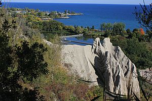
These cliffs are part of an old shoreline. This shoreline was formed by a huge ancient lake called Glacial Lake Iroquois. This lake existed after the last ice age, thousands of years ago. As the lake's edge eroded, it left behind important geological clues about Earth's past. The sand and dirt that eroded from the Bluffs settled further west. This is how the Toronto Islands were formed!
Challenges Facing the Bluffs
Erosion and Preservation
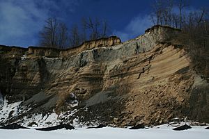
The Scarborough Bluffs have been eroding quite quickly. This has been happening especially since homes were built along the top of the cliffs. People wanted amazing views of the lake, and this led to many houses being built there. This building boom also sped up the rate of erosion.
Erosion can damage private property and costs money to fix. For example, in 2008, a part of the Bluffs collapsed. A quarter of a cottage, once owned by actor Billy Van, was left hanging over the cliff! City officials said it was too dangerous.
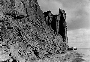
To help stop erosion, large rocks and trees are placed at the bottom of the cliffs. These act like a shield. Sometimes, to place these rocks, a temporary beach has to be made. This means moving some parts of the Bluffs, like at Bluffer's Park. The impressive "Cathedral Bluffs" section was actually created by this ongoing erosion.
In 2017, the Toronto Region Conservation Authority started the Scarborough Waterfront Project. This project aims to improve about 11 kilometers (7 miles) of the Bluffs' shoreline. It includes making the beach between Bluffer's Park and Meadowcliffe about 60 meters (200 feet) wider into Lake Ontario.
On August 23, 2020, a large part of the Bluffs near a lookout point collapsed onto a beach. People heard "explosion-like" sounds, followed by a cloud of dust. Some people were on the beach, but luckily, no one was hurt.
Safety at the Bluffs
The Scarborough Bluffs are a popular place for photographers and visitors. However, erosion and sometimes flooding can make them dangerous. The Toronto Region Conservation Authority warns that many people ignore safety signs. Areas that look solid can suddenly collapse.
It's safe to be in the park areas at the top of the Bluffs, as long as you stay behind the fences. Problems happen when people go past the safety fences. If you ignore the signs and enter restricted areas, you could face fines of up to $5,000. It's very important to stay safe and follow all warnings!
Parks Along the Bluffs
Many city parks are located along the Bluffs, from Victoria Park Avenue to the Rouge River. Most are on top of the cliffs, but some are at the bottom, right by Lake Ontario.
The creation of these parks began before 1960. From 1960 to 1978, the Toronto and Region Conservation Authority (TRCA) bought many of these lands. They then turned them into the parks we see today. Outside of these parks, many parts of the Bluffs are on private property.
Here are some of the parks you can find along the Bluffs:
- Bluffer's Park: This is the only park with direct access to the lake. It has a sandy beach and man-made hills that offer great views of both the Bluffs and the lake. It opened as a park in 1975.
- Cathedral Bluffs Park: This impressive part of the Bluffs was once owned by a group of nuns. The land near the cliff edge was kept as parkland.
- Chesterton Shores
- Crescentwood Park
- Cudia Park
- East Point Park: This park has added hills and land to create more waterfront space.
- Doris McCarthy Trail
- Gates Gully: This area has a partial beach and hills.
- Greyabbey Park
- Guild Park and Gardens
- Harrison Properties
- Port Union Waterfront Park: This park uses special walls in the water to protect the shoreline.
- Rosetta McClain Gardens: This beautiful garden park was opened in 1977.
- Rouge Beach Park
- Scarboro Crescent Park: This park is on top of the Bluffs and does not have access to the water. It was renamed to discourage people from trying to climb down the cliffs.
- Scarborough Heights Park
- South Marine Drive Park
- Sylvan Park: This park has protective walls in the water between it and Cudia Park.
Community Groups
There are two main community groups in the Scarborough Bluffs area:
- The Scarborough Bluffs Community Association, which helps the Birch Cliff, Cliffside, and Cliffcrest neighborhoods.
- The Guildwood Village Community Association, which helps the Guildwood Village neighborhood.
 | John T. Biggers |
 | Thomas Blackshear |
 | Mark Bradford |
 | Beverly Buchanan |


