Lake Warren facts for kids
Quick facts for kids Lake Warren |
|
|---|---|
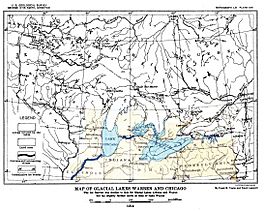
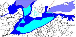
Map of Glacial Lakes Warren and Chicago (USGS 1915)
|
|
| Location | North America |
| Group | Great Lakes |
| Coordinates | 42°12′N 81°12′W / 42.2°N 81.2°W |
| Lake type | former lake |
| Etymology | Warren Upham |
| Primary inflows | Laurentide Ice Sheet |
| Primary outflows | Mohawk River |
| Basin countries | Canada United States |
| First flooded | 12,700 years before present |
| Max. length | 290 mi (470 km) |
| Max. width | 110 mi (180 km) |
| Residence time | 200 years in existence |
| Surface elevation | 690 ft (210 m) 680 ft (207 m) 675 ft (206 m) |
Lake Warren was a huge ancient lake that formed about 12,700 years ago. It was a "proglacial lake," which means it was created by melting ice from a giant glacier. This lake filled the area where Lake Erie is today.
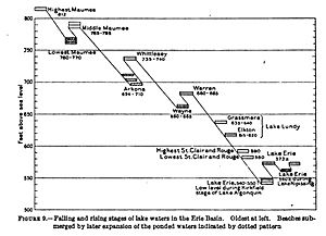
Lake Warren formed after another ancient lake, Lake Whittlesey, lowered its water level. Scientists divide Lake Warren's history into three main stages. Each stage is named after its height above sea level.
- Warren I: 690 feet (210 m) high
- Warren II: 680 feet (210 m) high
- Warren III: 675 feet (206 m) high
How Lake Warren Formed
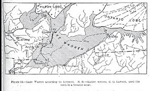
Lake Warren appeared after an earlier lake called Lake Wayne. It covered a very large area. This included the basin of Lake Erie and parts of Lake Huron. It also stretched into the area that separates Lake Huron from Lake Erie.
The lake also reached into a part of the Lake Ontario basin. It covered the lowlands between Lake Ontario and Lake Erie. The Saginaw basin and the Huron-Erie basin were also part of Lake Warren.
Its water flowed out through the Grand River into Lake Chicago. The land where the lake's old beach stood is about 680 feet (210 m) above sea level. This area was not affected by the land rising after the glaciers melted.
Lake Warren's waters rose because a huge ice sheet moved forward. This ice blocked the lower exit from Lake Wayne. The ice also squeezed the area where meltwater could collect. This made the water level rise, forming Lake Warren.
Size of the Lake
Lake Warren was about half the size of the modern Lake Erie. It mostly filled the southern part of the Lake Erie basin.
The Ancient Beach
The old beach of Lake Warren rises as you go north from the Grand River outlet. It goes up about 2 feet (0.61 m) for every mile. Near Gladwin, it reaches about 800 feet (240 m) high. It's also nearly 800 feet (240 m) high on the "Thumb" area in Huron County, north of Bad Axe.
The beach stays flat for about 300 miles (480 km) from Lenox, Michigan. This flat part goes around the western end of Lake Erie. Then it continues along the southern shore through Ohio to the Pennsylvania border. From there to Batavia, New York, it rises 200 feet (61 m) over the next 150 miles (240 km).
This beach shows that the lake stayed at this level for a long time. However, it was not as long as the times for Lake Arkona or Lake Whittlesey. The sand and gravel deposits from rivers flowing into the lake are not as widespread. The type of beach material changes. If the lakebed was clay or gravel, the beach was gravelly. If the lakebed was sandy, the beach was a sandy ridge.
Lake Warren and Lake Wayne
You can find strong but broken lines of sand and gravel ridges. These are about 40 feet (12 m) to 100 feet (30 m) below the old shoreline of Lake Whittlesey. These ridges are found in western New York, between 750 and 865 feet (229 and 264 m) high. They are linked to Glacial Lake Warren.
These ridges often appear with deltas, which are landforms created where rivers flow into a lake. The ridges are well-formed in some areas beyond the Allegheny Plateau. They are also found in the lowlands of Lake Erie and Lake Ontario. Often, these ridges and deltas sit on top of the silty lakebed of Lake Whittlesey.
 | Toni Morrison |
 | Barack Obama |
 | Martin Luther King Jr. |
 | Ralph Bunche |


