Huron County, Michigan facts for kids
Quick facts for kids
Huron County
|
|
|---|---|

|
|

Location within the U.S. state of Michigan
|
|
 Michigan's location within the U.S. |
|
| Country | |
| State | |
| Founded | April 1, 1840 (created) January 25, 1859 (organized) |
| Named for | Lake Huron |
| Seat | Bad Axe |
| Largest city | Bad Axe |
| Area | |
| • Total | 2,137 sq mi (5,530 km2) |
| • Land | 836 sq mi (2,170 km2) |
| • Water | 1,301 sq mi (3,370 km2) 61%% |
| Population
(2020)
|
|
| • Total | 31,407 |
| • Density | 15/sq mi (6/km2) |
| Time zone | UTC−5 (Eastern) |
| • Summer (DST) | UTC−4 (EDT) |
| Congressional district | 9th |
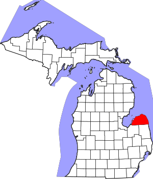
Huron County is a county located in the state of Michigan, United States. In 2020, about 31,407 people lived here. The main city and government center is Bad Axe.
Huron County is at the very top of a part of Michigan called "the Thumb." This area is shaped like a thumb on a hand. It's a peninsula, which means it's surrounded by water on three sides. To the west is Saginaw Bay, and to the north and east is Lake Huron. The county has over 90 miles (145 km) of shoreline!
The biggest industry in Huron County is agriculture, which means farming. Many other counties in "the Thumb" also focus on farming. People from big cities like Detroit, Flint, and Saginaw love to visit Huron County for vacations, especially around Port Austin and Caseville.
Contents
History of Huron County
Huron County was first connected to nearby Sanilac and Tuscola counties. It officially became its own county on April 1, 1840. It was fully set up as a county on January 25, 1859.
The first county seat (where the main government offices are) was Sand Beach, which is now called Harbor Beach. In 1865, the courthouse there burned down, and many important records were lost. So, the county seat moved to Port Austin. It stayed there until 1873, when the county leaders decided to move it to Bad Axe, where it is today.
How Huron County Got Its Name
The name "Huron" comes from the word "hures." This word was used by a French traveler who was surprised by how the Wyandotte (Huron) Native Americans styled their hair.
In the 1600s, the Iroquois people from New York and Pennsylvania fought the Wyandotte people. This was part of the Beaver Wars, where groups fought to control the fur trade. The Iroquois drove the Wyandotte out of this area.
The Wyandotte people used words like "onti" or "ondi" in their place names. These words meant "to jut out," like a peninsula. The name "Wyandotte" itself is thought to mean "dwellers of the peninsula."
In the early 1700s, the "Thumb" area of Michigan was known for having some of the best beaver hunting in America. French maps from around 1700 called this region "the beaver hunting grounds of the friends of Francis."
Geography and Nature
Huron County covers a total area of about 2,137 square miles (5,535 sq km). A large part of this area, 1,301 square miles (3,370 sq km), is water, making up 61% of the county! The land area is about 836 square miles (2,165 sq km).
The county is mostly flat, but you can find some gentle rolling hills. Farming is a very important activity here.
Neighboring Counties
Huron County shares borders with other counties.
- By land:
- Sanilac County to the southeast
- Tuscola County to the southwest
- By water:
- Arenac County to the northwest
- Iosco County to the northwest
Main Roads
Several important highways run through Huron County, helping people travel around:
 M-19 - This road goes north and south through the southern part of the county.
 M-25 - This highway follows the shoreline of Lake Huron and Saginaw Bay.
 M-53 - This road runs north and south through the middle of the county.
- M-142 - This road goes east and west through the central part of the county.
People of Huron County
| Historical population | |||
|---|---|---|---|
| Census | Pop. | %± | |
| 1850 | 210 | — | |
| 1860 | 3,165 | 1,407.1% | |
| 1870 | 9,049 | 185.9% | |
| 1880 | 20,089 | 122.0% | |
| 1890 | 28,545 | 42.1% | |
| 1900 | 34,162 | 19.7% | |
| 1910 | 34,758 | 1.7% | |
| 1920 | 32,768 | −5.7% | |
| 1930 | 31,132 | −5.0% | |
| 1940 | 32,584 | 4.7% | |
| 1950 | 33,149 | 1.7% | |
| 1960 | 34,006 | 2.6% | |
| 1970 | 34,083 | 0.2% | |
| 1980 | 36,459 | 7.0% | |
| 1990 | 34,951 | −4.1% | |
| 2000 | 36,079 | 3.2% | |
| 2010 | 33,118 | −8.2% | |
| 2020 | 31,407 | −5.2% | |
| 2023 (est.) | 30,927 | −6.6% | |
| US Decennial Census 1790-1960 1900-1990 1990-2000 2010-2018 |
|||
The 2010 United States Census showed that Huron County had 33,118 people. This was a decrease of about 8.2% from the year 2000.
Most people in Huron County are White (97.5%). Smaller groups include Asian, Black or African American, and Native American people. About 2% of the population is Hispanic or Latino. Many people have German, Polish, or Irish family backgrounds.
In 2010, there were 14,348 households in the county. About 24.7% of these households had children under 18 living with them. The average household had 2.27 people.
The population is spread out by age. About 20.7% of people are under 18 years old. About 21.7% are 65 years or older. The average age in the county was 47 years old.
Religion in Huron County
Several religious groups have a presence in Huron County:
- The United Methodist Church is very active in this region.
- The Roman Catholic Diocese of Saginaw oversees Catholic churches in the area.
- Episcopal churches are part of the Episcopal Diocese of Eastern Michigan.
- The Church of Jesus Christ of Latter-day Saints has one meetinghouse in Huron County.
Fun Parks and Recreation
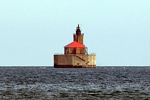
Tourism is a big part of Huron County's economy. Many people visit the towns along the bay and lake, like Sebewaing, Caseville, Port Austin, Port Hope, and Harbor Beach.
There are two state parks where you can enjoy nature:
The county also has three smaller roadside parks: Jenks Park, Brown Park, and White Rock Park. Plus, Huron County manages eight county parks right along the shoreline, perfect for enjoying the water:
- Caseville Park
- Lighthouse Park
- Stafford Park
- McGraw Park
- Philp Park
- Wagener Park
- Oak Beach Park
- Sebewaing Park
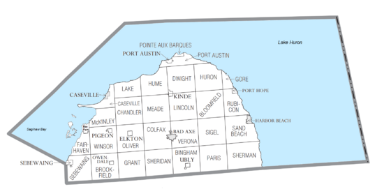
Communities in Huron County
Cities
- Bad Axe (This is the county seat, where the main government offices are located.)
- Caseville
- Harbor Beach
Villages
Civil Townships
- Bingham Township
- Bloomfield Township
- Brookfield Township
- Caseville Township
- Chandler Township
- Colfax Township
- Dwight Township
- Fairhaven Township
- Gore Township
- Grant Township
- Hume Township
- Huron Township
- Lake Township
- Lincoln Township
- McKinley Township
- Meade Township
- Oliver Township
- Paris Township
- Pointe Aux Barques Township
- Port Austin Township
- Rubicon Township
- Sand Beach Township
- Sebewaing Township
- Sheridan Township
- Sherman Township
- Sigel Township
- Verona Township
- Winsor Township
Census-designated place
Other Unincorporated Communities
See also
 In Spanish: Condado de Huron (Míchigan) para niños
 | James B. Knighten |
 | Azellia White |
 | Willa Brown |


