Sebewaing, Michigan facts for kids
Quick facts for kids
Sebewaing, Michigan
|
|
|---|---|
|
Village
|
|

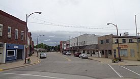
Business district along Center Street
|
|

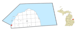
Location within Huron County
|
|
| Country | United States |
| State | Michigan |
| County | Huron |
| Township | Sebewaing |
| Founded | 1845 |
| Incorporated | 1879 (village) |
| Government | |
| • Type | Village council |
| Area | |
| • Total | 1.72 sq mi (4.44 km2) |
| • Land | 1.59 sq mi (4.12 km2) |
| • Water | 0.13 sq mi (0.32 km2) |
| Elevation | 584 ft (178 m) |
| Population
(2020)
|
|
| • Total | 1,721 |
| • Density | 1,082.39/sq mi (418.00/km2) |
| Time zone | UTC-5 (Eastern (EST)) |
| • Summer (DST) | UTC-4 (EDT) |
| ZIP code(s) |
48759
|
| Area code(s) | 989 |
| FIPS code | 26-72180 |
| GNIS feature ID | 0637513 |
Sebewaing (say "SEE-bah-wing") is a small village in Huron County, Michigan. In 2020, about 1,721 people lived there. It is part of Sebewaing Township.
Sebewaing is often called the "Sugar Beet Capital." This is because the Michigan Sugar has a factory in the village. Every year, the village also hosts the Michigan Sugar Festival. The area around Sebewaing, known as the Thumb, and the state of Michigan grow a lot of sugar beets. Most of this sugar is used within the United States.
Sebewaing was also the first "gigabit village" in Michigan. Between 2014 and 2015, the village built a special fiber optic network. This network offers very fast internet speeds, up to one gigabit per second, to homes.
Contents
About Sebewaing's Location
Sebewaing covers about 1.71 square miles (4.44 square kilometers). Most of this area is land, with a small part being water.
What Does "Sebewaing" Mean?
The name "Sebewaing" likely comes from the Ojibwe language. Some people think it means "place by the river." Another idea is that it comes from "Zibii-wayaan-aki," which means "river in the fur or pelt country."
In the 1700s, French explorers called the Thumb region of Michigan "les Pays Peles." This means "the land of pelts or furs." The Cass River, which is south of Saginaw Bay, was once called Onottoway-Sebewing. The Sebewaing River, where the village is located, was called "Le Rivier du Fil" by the French. This means "the thread river."
The village is right on the banks of the Sebewaing River and the Saginaw Bay shoreline. This location was good for making threads or strings. Native Americans might have used these to make nets, fishing lines, or other tools. They often used willow trees, which they planted along rivers, to make string.
Sebewaing in the Thumb Region
Sebewaing is part of an area in Michigan known as the Thumb. This area is also a smaller part of the larger Flint/Tri-Cities region.
Sebewaing's History
The name Sebewaing comes from the Algonquian language spoken by the Native Americans who first lived in this area.
The village was started in 1845 by Rev. John J.F. Auch. He was a Lutheran minister who came to work with the Native American communities.
German Settlers and Breweries
In the mid-1800s, many people from Germany moved to Sebewaing. In 1880, a company called E.O. Braendle Brewery started making beer.
However, during Prohibition, it became illegal to make and sell alcohol. So, the brewery had to close. In 1927, it reopened under a new name, the Sebewaing Brewing Company. This company made many types of German-style beer until 1965. Later, another company called Michigan Brewing Company used some of the old recipes and labels to bring back these beers.
Population Changes
| Historical population | |||
|---|---|---|---|
| Census | Pop. | %± | |
| 1880 | 553 | — | |
| 1890 | 719 | 30.0% | |
| 1900 | 1,243 | 72.9% | |
| 1910 | 1,347 | 8.4% | |
| 1920 | 1,446 | 7.3% | |
| 1930 | 1,441 | −0.3% | |
| 1940 | 1,598 | 10.9% | |
| 1950 | 1,911 | 19.6% | |
| 1960 | 2,026 | 6.0% | |
| 1970 | 2,053 | 1.3% | |
| 1980 | 2,046 | −0.3% | |
| 1990 | 1,923 | −6.0% | |
| 2000 | 1,974 | 2.7% | |
| 2010 | 1,759 | −10.9% | |
| 2020 | 1,721 | −2.2% | |
| U.S. Decennial Census | |||
Sebewaing in 2010
In 2010, there were 1,759 people living in Sebewaing. There were 802 households, and 491 of these were families. The village had about 1,113 people per square mile.
Most people in the village (97.5%) were White. A small number were Native American (0.2%) or Asian (0.2%). About 1.3% were from other races, and 0.9% were from two or more races. About 4.3% of the population were Hispanic or Latino.
About 26.2% of households had children under 18 living with them. Many households (46.8%) were married couples. About 33.7% of households were single people living alone. About 16.7% of households had someone aged 65 or older living alone. The average household had 2.19 people, and the average family had 2.79 people.
The average age in the village was 44.9 years old. About 20.8% of residents were under 18. About 20.8% were 65 or older. The village had slightly more females (50.8%) than males (49.2%).
Sebewaing's Climate
Sebewaing has a humid continental climate. This means it has big changes in temperature throughout the year. Summers are warm to hot and often humid. Winters are cold, and sometimes very cold. This type of climate is called "Dfb" on climate maps.
Education in Sebewaing
The schools in Sebewaing are part of the Unionville-Sebewaing Area Schools. Unionville-Sebewaing Area High School was created when the high schools from Unionville and Sebewaing joined together.
If students want to go to college or other higher education, the closest places are in Cass City to the east and Bay City to the west.
See also

- In Spanish: Sebewaing para niños
 | William Lucy |
 | Charles Hayes |
 | Cleveland Robinson |


