Lake Whittlesey facts for kids
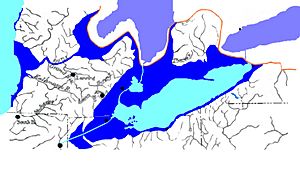
Lake Whittlesey was a huge lake that existed long ago, about 14,000 years ago. It was like an ancestor to today's Lake Erie. This ancient lake formed when a giant ice sheet, called the Wisconsin Glacier, started to melt and pull back. The melting ice created a lot of water, which filled up a low area that used to be a river valley. This old river, called the Erigan River, probably flowed east and emptied into the Atlantic Ocean where the Saint Lawrence River is now.
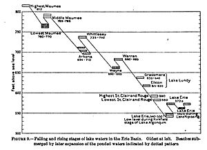
Lake Whittlesey was quite high up, sitting about 735 feet (224 m) to 740 feet (230 m) above sea level. The old shoreline, called the Belmore Beach, isn't flat everywhere. That's because the land has slowly risen in some places after the heavy ice sheet melted away. This rising of the land is called isostatic rebound. The land rose more in the north, especially in Michigan, by about 60 feet (18 m). The Ubly outlet, which was where water flowed out of the lake, is now 800 feet (240 m) above sea level.
The Belmore Beach is a gravel ridge, about 10 feet (3.0 m) to 15 feet (4.6 m) high and 18 meters wide. Lake Whittlesey stayed at this level until the ice melted enough to open a lower path for the water to flow out. This caused the lake level to drop by about 20 feet (6.1 m), leading to the formation of Lake Warren. The land between the old Whittlesey and Warren beaches in southeastern Michigan is mostly a flat, clayey area.
Frank Taylor named this ancient lake Lake Whittlesey in 1897. He did this to honor Charles Whittlesey, a geologist. The lake's water flowed across the "Thumb" area of Michigan through an exit point called the Ubly outlet.
River Deltas and Lake Whittlesey
When rivers flow into a lake, they often drop the dirt and rocks they carry, forming a landform called a delta. Lake Whittlesey had several deltas. For example, you can find old delta deposits near Ypsilanti on the Huron River. Other deltas formed on the Rouge River near Plymouth and on the Clinton River below Rochester. These deltas actually started forming during an earlier lake stage, Lake Maumee.
During the time of an even older lake, Lake Arkona, river valleys became deeper and wider. When the ice sheet grew again and water levels rose, the lower parts of these rivers became flooded. They turned into calm, deep areas called estuaries. River deposits would start to build up at the very beginning of these flooded areas. A Lake Whittlesey delta would only form after these estuaries were completely filled in.
Today, most of these old deltas from Lake Whittlesey have been worn away by the modern Lake Erie. Only small pieces remain as gravel terraces along the edges of the old estuaries. The best remaining one is along the Huron River below Ypsilanti.
In New York, there's one delta that formed in Lake Whittlesey. It's located a couple of miles east of Alden. The river that created this delta flowed west, right along the edge of the ice sheet. This delta is special because it wasn't formed inside an estuary like most others.
In Ontario, Canada, there are three Lake Whittlesey deltas, and they are bigger than any in the United States. One is on the Grand River between Paris and Brantford. Another is on the Thames River between Komoka and London. A third large delta was made by a big glacial river that flowed from the northeast along the ice front. It entered Lake Whittlesey a few miles northwest of Clinton. The first two are like the deltas in Michigan, formed within old estuaries. The third, like the one near Alden, New York, was built by a river flowing along the ice's edge.
Other Lakes at the Same Time
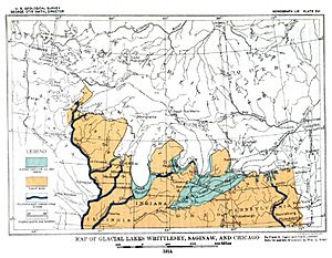
When Lake Whittlesey existed, Lake Saginaw was a separate lake. Water from Lake Whittlesey flowed into Lake Saginaw. Then, Lake Saginaw's water flowed into Lake Chicago, which was much smaller back then.
In New York, another ancient lake called Lake Newberry existed at the same time as Lake Whittlesey. However, Lake Newberry's water flowed south into the Susquehanna River, not into Lake Whittlesey.
 | Sharif Bey |
 | Hale Woodruff |
 | Richmond Barthé |
 | Purvis Young |


