
Lake Saginaw facts for kids
Quick facts for kids Lake Saginaw |
|
|---|---|

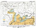
First Lake Saginaw - Map of Glacial lakes Whittlesey, Sagniaw and Chicago, based on the USGS Report of 1915.
|
|

Lake Saginaw
Location in Michigan
|
|
| Location | North America |
| Group | Great Lakes |
| Coordinates | 43°55′N 83°35′W / 43.917°N 83.583°W |
| Lake type | former lake |
| Etymology | Saginaw Bay |
| Primary inflows | Laurentide Ice Sheet |
| Primary outflows | Grand River valley in Michigan |
| Basin countries | Canada United States |
| First flooded |
|
| Max. length | 70 mi (110 km) |
| Max. width | 26 mi (42 km) |
| Residence time | 100 years in existence |
| Surface elevation | 700 ft (213 m) |
Lake Saginaw was a large ancient lake that once filled the area of what is now Saginaw Bay in Michigan. It existed during the Ice Age, when huge glaciers covered much of North America. This lake was special because it had two separate times when it was its own independent lake. It wasn't connected to other larger lakes in the Lake Huron area.
The first time Lake Saginaw existed was around the same time as the later stages of another ancient lake called Lake Maumee. Later, when the ice melted and opened a path, these two lakes joined together. This created an even bigger lake known as Lake Arkona. But then, the glaciers moved forward again. This closed the connection, and Lake Saginaw became independent once more. This second period happened during the time of Lake Whittlesey.
Eventually, the ice retreated for good. Lake Saginaw then became a part of larger ancient lakes like Lake Wayne, Lake Warren, and Lake Lundy. When Lake Saginaw was an independent lake, its water flowed out through the Grand River valley in Michigan.
Contents
First Lake Saginaw: How It Formed
The First Lake Saginaw began to form after a ridge of glacial debris, called the Flint moraine, was built. Also, a channel, known as the Imlay channel, was created by melting ice water. As the giant ice sheet pulled back from the Saginaw area, land was uncovered. Water from the melting glacier started to collect in this basin. This is how the First Lake Saginaw was born.
The water from this lake flowed out through the Grand River. This river then carried the water to Lake Chicago, another ancient lake that collected glacial runoff. You can still see clear ancient beaches around the Grand River outlet. These beaches are about 700 feet (210 m) above sea level. In some areas, especially to the north and west, these old beaches are even higher. This is because the land slowly rose up after the heavy weight of the glaciers was removed. The bottom of the lake was a mix of sandy and clay soils. Sand was mostly found near the edges of the lake, where waves and currents moved it around.
Lake Saginaw Joins Lake Arkona
Imagine a giant ice wall blocking off a part of the land. When this ice wall moved away from the "thumb" area of Michigan, a narrow passage opened up. This allowed the waters on both sides to mix and become one big lake. This new, larger lake was called Lake Arkona. Lake Saginaw, with its steady outlet, became the main part of this new lake. It was like Lake Saginaw just got much bigger, still using the same outlet and keeping its original shorelines. This is when the first Arkona beaches started to form. One of these new Arkona beaches actually merged with an existing beach from Lake Saginaw.
Second Lake Saginaw: A Return to Independence
.JPG)
After Lake Arkona, the ice front moved forward again. It closed the passage around the "thumb" of Michigan. This caused the water level to rise by about 44 feet to the east. This rise created a new lake called Lake Whittlesey. However, this change didn't really affect how much water flowed out of Lake Saginaw. Before, Lake Maumee had flowed into Lake Saginaw. After Lake Arkona disappeared, Lake Whittlesey started flowing into it. So, the amount of water leaving Lake Saginaw stayed pretty much the same.
During the time of Lake Whittlesey, Lake Saginaw became an independent lake again. It was almost at its largest size during this period. It seems that the lower ridge of the Arkona beach in the Saginaw area was mostly formed by the waves of Lake Arkona. It's also likely that during the time of Lake Whittlesey, the waves of Lake Saginaw hit this same beach.
The Second Lake Saginaw stretched to about the same western and southern limits as the First Lake Saginaw. This is because its water still flowed out through the same channel, along the Grand River, to Lake Chicago. The water level was only a few feet lower. On the northeast side, towards the ice, the lake's edge was clearly defined by the Port Huron moraine (another glacial ridge). The lake extended up the Cass River valley to near Cass City. It also reached up the Tittabawassee valley into parts of Gladwin and possibly Ogemaw counties.
Lake Saginaw Joins Lake Wayne
When the water levels dropped from Lake Whittlesey, they fell about 80 feet. This didn't lead to the Warren beach level, as one might expect, but to the Wayne beach level. This Wayne beach is about 20 feet lower than the Warren beach. It shows signs of being underwater again after it was formed, similar to the Arkona beaches. There's a good chance this lake dropped even lower before it ended. While Lake Saginaw was part of Lake Wayne, it stopped using the Grand River channel. The water level was a bit too low for that outlet.
Lake Saginaw Joins Lake Warren
When the ice barrier moved forward into Lake Wayne, the water level rose again. It reached the level of the Warren beach. Once more, the Grand River became the main outlet for the water. This stage of the lake is called Lake Warren. Its shorelines were about 25 feet (7.6 m) or 30 feet (9.1 m) lower than the Arkona ridges.
Lake Saginaw Joins Lake Lundy
Lake Lundy formed after Lake Warren. This happened when a new outlet opened to the east, through the Mohawk River Valley. The Grand River outlet was no longer used after this. Lake Saginaw had already ended its independent existence when it became part of Lake Warren. The opening of this new, lower outlet to the east meant there was no chance for another independent lake to form in Saginaw Bay.
The Grand River Channel: A Long-Used Pathway
The Grand River channel was used for a very long time by the ancient lakes in Michigan. It started carrying lake waters even before Lake Saginaw formed. This was when the outlet of Lake Maumee first opened near Imlay. Later, it carried water from Lake Maumee through the First Lake Saginaw. Then, it carried the overflow from the combined Lakes Arkona and Saginaw. After that, it carried the waters of Lake Whittlesey and Saginaw.
The Grand River channel was only temporarily abandoned when the ice retreated from the Port Huron moraine system. At that point, Lake Saginaw merged eastward and became part of Lake Wayne. Before this, the Grand River channel had carried the overflow continuously. Later, the ice advanced again, closing the eastern outlet near Syracuse. This created Lake Warren, which also flowed out through the Grand River channel. The Warren beaches are about 20 feet (6.1 m) or 25 feet (7.6 m) above the wide, swampy, and sandy area at the start of the channel, north of Bannister.
Images for kids
-
Second Lake Saginaw - Map of Glacial Lakes Duluth, Chicago, and Lundy (USGS 1915)
