Lake Wayne facts for kids
Quick facts for kids Lake Wayne |
|
|---|---|
| Location | North America |
| Group | Great Lakes |
| Coordinates | 42°14′23″N 83°17′27″W / 42.2396°N 83.2909°W |
| Lake type | former lake |
| Etymology | Wayne County, Michigan |
| Primary inflows | Laurentide Ice Sheet |
| Primary outflows | Mohawk River |
| Basin countries | Canada United States |
| First flooded | 12,500 years before present |
| Max. length | 241 mi (388 km) |
| Max. width | 57 mi (92 km) |
| Residence time | 500 years in existence |
| Surface elevation | 476 ft (145 m) |
Lake Wayne was a huge ancient lake that existed about 12,500 years ago. It formed in the areas where Lake Erie and Lake St. Clair are today. This happened when another large ancient lake, Lake Arkona, became lower.
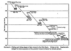
Lake Wayne was once thought to be just a lower part of Lake Warren, another ancient lake. But scientists found clues in Wayne County, Michigan, that showed Lake Wayne was a separate lake. It formed after Lake Whittlesey and before Lake Warren.
Unlike some other ancient lakes, Lake Wayne's water didn't flow west through the Grand River. Instead, it flowed east along the edge of the giant ice sheet. This water traveled all the way to Syracuse, New York, and then into the Mohawk River valley. Because its water flowed in a different direction, scientists decided it was a unique lake, separate from Lake Warren.
Contents
The Story of Lake Wayne
The land around Lake Wayne was shaped by its existence. The "Wayne beach" is a sandy or gravel ridge that shows where the edge of the lake once was. This beach is found in Michigan, Ohio, Pennsylvania, and New York. In Wayne County, Michigan, it's a sandy ridge. But further east in Ohio, it's made of gravel.
How Lake Wayne Changed
The Wayne beach is lower than the Lake Warren beach. It seems to be older because it shows signs of being covered by water and changed over time. This means the Wayne beach was underwater and changed when Lake Warren existed. The lowest level of Lake Wayne might have happened at the same time as the early stages of Lake Algonquin, another huge ancient lake.
Where Lake Wayne's Water Went
Scientists believe Lake Wayne existed during a warm period called the Two Creeks Interstade. During this time, its water drained eastward into the Hudson River. Studies in western New York suggest that a lot of ice melted quickly, leaving behind sand and gravel. Then, the ice sheet moved forward again.
Some scientists think Lake Wayne might have lasted until the ice edge moved north, closer to where Niagara Falls is now. If this happened, the lake's water level would have risen, forming the Warren III lake.
The Ancient Beach
The ancient beach of Lake Wayne is easy to spot from the Ohio-Michigan border near the Black River all the way to Port Huron. It's often made of fine sand, some of which was blown by the wind. Sometimes, it's even buried under other layers of earth.
The beach enters Michigan a few miles northeast of Sylvania, Ohio. Here, it's a wide, sandy area, about 6 miles (9.7 km) across. This sandy area is slightly above 660 feet (200 m) in elevation. It has many sand dunes with swampy areas in between. It also includes a delta (where a river flows into a lake) at the Huron River near Romulus. Near Wayne, the beach is made of sandy gravel. It's about 15 to 20 rods (75 to 101 m) wide and stands 10 to 12 feet (3.0 to 3.7 m) above the land to its east, and 5 to 6 feet (1.5 to 1.8 m) above the land to its west.
 | Kyle Baker |
 | Joseph Yoakum |
 | Laura Wheeler Waring |
 | Henry Ossawa Tanner |


