
Wayne, Michigan facts for kids
Quick facts for kids
Wayne, Michigan
|
||
|---|---|---|
| City of Wayne | ||
.jpg)
Downtown Wayne
|
||
|
||
,_MI_location.png)
Location within Wayne County
|
||

Wayne, Michigan
Location in Michigan

Wayne, Michigan
Location in the United States
|
||
| Country | ||
| State | ||
| County | ||
| Settled | 1824 | |
| Incorporated | 1869 (village) 1960 (city) |
|
| Named for | Anthony Wayne | |
| Area | ||
| • City | 6.02 sq mi (15.59 km2) | |
| • Land | 6.02 sq mi (15.59 km2) | |
| • Water | 0.00 sq mi (0.00 km2) | |
| Elevation | 656 ft (200 m) | |
| Population
(2020)
|
||
| • City | 17,713 | |
| • Density | 2,942.36/sq mi (1,136.10/km2) | |
| • Metro | 4,285,832 (Metro Detroit) | |
| Time zone | UTC-5 (EST) | |
| • Summer (DST) | UTC-4 (EDT) | |
| ZIP code(s) |
48184
|
|
| Area code(s) | 734 | |
| FIPS code | 26-84940 | |
| GNIS feature ID | 1615901 | |

Wayne is a city in Wayne County, Michigan. It's a western suburb of Detroit, located about 18 kilometers (11 miles) southwest of downtown Detroit. In 2020, about 17,713 people lived there. Wayne is well-known for its long history of making cars and other transportation equipment. Ford Motor Company has two plants in Wayne: Wayne Stamping & Assembly and the Michigan Assembly Plant.
Contents
History of Wayne, Michigan
The area where Wayne is now located was once crossed by the Sauk Trail. This trail was used by Potawatomi people and French fur traders for many years before people started living there permanently.
Early Settlement and Growth
The first settler was George M. Johnson in 1824. He built a small log cabin that served as a place for travelers to stop. This area became known as Johnson's Tavern. Later, Ezra Derby bought the land in 1832. He started building a settlement, adding a sawmill, a store, and a blacksmith shop. In 1834, the area was officially named Derby's Corners.
In 1836, the name was changed to Wayne. This was done to honor Anthony Wayne, a famous general from the American Revolutionary War. The town grew faster when the Michigan Central Railroad arrived in 1838. The main road through Wayne, originally called the Chicago Road, was paved with oak logs in 1850. It was later renamed Michigan Avenue in 1867. In 1869, Wayne became an official village with about 800 people. It officially became a city in 1960.
Wayne's Industrial Development
Many important factories have been built in Wayne over the years. The Prouty and Glass Carriage Factory moved here in 1888. This made Wayne the biggest producer of carriages and sleighs in the country at that time.
In 1899, an interurban railroad (a streetcar system) connected Wayne to Detroit. This made travel easier until 1929. Famous car makers also had factories here:
- Ray Harroun, who won the first Indianapolis 500, built the Harroun motor car in Wayne from 1916 to 1921.
- The Gotfredson Truck was made from 1924 to 1927.
- The Graham-Paige car company made vehicles from 1928 to 1936.
Stinson Aircraft also made small planes near Wayne from 1926 to 1948. The Michigan Assembly Plant was built in 1957. Other big companies like Gar-Wood, Unistrut, and Wayne Industries have also had a presence in the city. After World War II, Wayne's population and factory production grew a lot.
Geography of Wayne
Wayne is located on the Lower River Rouge, which flows through the city. The city's borders are Glenwood Road to the north, Hannan Road to the west, Van Born Road to the south, and Merriman Road to the east.
According to the United States Census Bureau, the city covers a total area of about 15.59 square kilometers (6.02 square miles). All of this area is land.
Population and People
| Historical population | |||
|---|---|---|---|
| Census | Pop. | %± | |
| 1860 | 304 | — | |
| 1870 | 833 | 174.0% | |
| 1880 | 919 | 10.3% | |
| 1890 | 1,226 | 33.4% | |
| 1900 | 1,361 | 11.0% | |
| 1910 | 1,263 | −7.2% | |
| 1920 | 1,899 | 50.4% | |
| 1930 | 3,423 | 80.3% | |
| 1940 | 4,223 | 23.4% | |
| 1950 | 9,409 | 122.8% | |
| 1960 | 16,034 | 70.4% | |
| 1970 | 21,054 | 31.3% | |
| 1980 | 21,159 | 0.5% | |
| 1990 | 19,899 | −6.0% | |
| 2000 | 19,051 | −4.3% | |
| 2010 | 17,593 | −7.7% | |
| 2020 | 17,713 | 0.7% | |
| U.S. Decennial Census | |||
Facts from the 2010 Census
In 2010, there were 17,593 people living in Wayne. There were 7,055 households, and 4,450 families. The city had about 2,922 people per square mile.
- About 76.3% of the people were White.
- About 17.1% were African American.
- About 2.1% were Asian.
- About 3.4% were Hispanic or Latino.
About 32.6% of households had children under 18 living with them. The average age of people in Wayne was 38.6 years. About 23.5% of residents were under 18 years old.
Education in Wayne
Wayne is part of the Wayne-Westland Community School District. Here are some of the schools located in Wayne:
- Benjamin Franklin Middle School
- Roosevelt-McGrath Elementary School
- Taft-Galloway Elementary School
- Wayne Memorial High School
- Wayne Westland Community High School
Private Schools in Wayne
- St. Michael Lutheran School (for grades Pre-K through 8th)
- St. Mary's Catholic School (now closed)
- St. Joseph's Catholic School (now closed)
Students living in Wayne also attend Adams Upper Elementary School in Westland and Walker-Winter Elementary School in Canton.
Notable People from Wayne
- Bill Stafford (1938–2001) was a professional baseball player. He was known for playing with the New York Yankees.
Images for kids
-
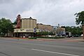
State Wayne Theater (1946)
-
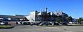
Michigan Assembly Plant

See also
 In Spanish: Wayne (Míchigan) para niños
