Lake Maumee facts for kids
Quick facts for kids Lake Maumee |
|
|---|---|

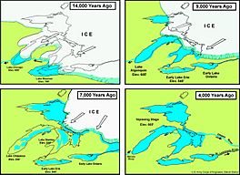
Stages of great lake development.
|
|
| Location | North America |
| Group | Great Lakes |
| Coordinates | 41°48′48″N 82°27′55″W / 41.8133°N 82.4652°W |
| Lake type | former lake |
| Etymology | Wabash River Sixmile Creek Channel, 780 ft (238 m) Imlay Outlet, 849 ft (259 m) |
| Primary inflows | Laurentide Ice Sheet |
| Primary outflows | Wabash River |
| Basin countries | Canada United States |
| First flooded | 14,000 years before present |
| Max. length | 326 mi (525 km) |
| Max. width | 113 mi (182 km) |
| Residence time | 1300 years in existence |
| Surface elevation | 800 ft (244 m) |
Lake Maumee was a huge ancient lake. It formed about 14,000 years ago. This lake was an early version of today's Lake Erie. It appeared as a giant ice sheet, called the Laurentide Ice Sheet, melted away. This happened at the end of the last major ice age. As the ice continued to melt, Lake Maumee changed. It later became other lakes, like Lake Arkona and Lake Whittlesey.
Contents
How Lake Maumee Formed
When the last ice age ended, a massive ice sheet began to melt. This melting ice left behind a lot of water. This water filled a low-lying area. This area used to be a river valley. It was the valley of the Erigan River. This river likely flowed east into the Atlantic Ocean. It probably followed the path of today's Saint Lawrence River.
Some scientists think the Erigan River was part of an even older river system. This system was called the Teays River. Glaciers changed the land a lot. They destroyed old river paths. They also made the Erigan valley bigger and deeper.
Lake Maumee was the first of many large lakes in the Erie basin. Before it, there were smaller lakes. These lakes were located between the edge of the ice and the southern hills of the Erie basin. The name Lake Maumee was first used in 1888. It was named by G. R. Dryer, a geologist from Indiana.
Water Levels and Outlets
As the ice sheet melted, it left behind large piles of dirt and rocks. These piles are called moraines. One such moraine was left near present-day Fort Wayne, Indiana. This moraine acted like a dam. It held back the water of Lake Maumee.
When the lake was at its highest, it was about 800 feet (244 meters) above sea level. At this height, the water left marks on the land. These marks are called beach ridges. These ridges later became paths for trails and roads.
At one point, the lake's water spilled over a low spot in the Fort Wayne Moraine. This caused a huge flood. It was called the Maumee Torrent. This flood carved a wide channel. This channel ran southwest to the Wabash River. It is known as the Wabash-Erie Channel.
Where the Water Flowed Out
The first place the lake's water flowed out was near Fort Wayne, Indiana. This was the lowest spot around the lake. At first, the water level there was about 785 feet (239 meters). This was 212 feet (65 meters) higher than today's Lake Erie. Over time, the outlet wore down to about 760 feet (232 meters).
When the lake was at its highest, it only used this one outlet. Later, more ice melted. A new outlet opened to the north. This was near Imlay City, Michigan. For a short time, the lake had two places where its water could flow out.
The highest beach marks are found near the Fort Wayne outlet. They are about 785 to 790 feet (239 to 241 meters) high. In Michigan, they are about 800 feet (244 meters) high. In some parts of Lapeer County, Michigan, they are nearly 850 feet (259 meters) high. The Imlay outlet was about 805 to 810 feet (245 to 247 meters) above sea level. This was about 50 feet (15 meters) higher than the Fort Wayne outlet.
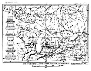
The water from the Imlay outlet flowed west. It went into a growing Lake Saginaw. From there, it flowed into the Grand River Channel. This channel included parts of the proto Maple and Lower Grand rivers.
The highest beach left by the lake is very uneven. This is because it was exposed to waves for a long time. The second beach is more regular. It is also stronger than the highest one. There is also a third beach. This one is weaker and harder to find. The third beach connects to clear deltas. These deltas are not found at the higher lake levels. The most notable deltas are at the River Raisin and the Huron rivers. The third beach is about 20 feet (6 meters) below the Imlay outlet.
These old lake beaches are made of sand or gravel. This made them good places for early roads. People built roads along these natural routes. Today, most roads are built in straight lines, north-south or east-west. Because of this, many of these old "beach roads" are no longer used.
Stages of Lake Maumee's Retreat
| Stages of Glacial Lake Maumee | ||||
| Stage | Years Ago | Elevation (ft) | Elevation (m) | Outlet |
| Highest | 14,000 | 800 | 244 | Wabash-Erie Channel |
| Lowest | 13,800 | 760 | 232 | Grand River |
| Middle | - | 780 | 238 | Imlay Outlet |
Lake Maumee had two later stages. These were called the "Lowest" and the "Middle" stages. During these times, the water levels were lower. This happened because the melting ice opened up new outlets. These new outlets were lower than the Wabash-Erie Channel.
The Lowest Maumee stage had a water level of about 760 feet (232 meters) above sea level. Its water flowed west through the Grand River in Michigan. From there, it flowed into Glacial Lake Chicago. This was an early version of today's Lake Michigan.
Then, the ice advanced again. This blocked the Grand River outlet. The lake's water level rose to about 780 feet (238 meters) above sea level. This was the Middle Maumee stage. A new outlet formed. It was called the Imlay Outlet. This outlet connected to a part of the Grand River that was not blocked by ice. Some experts are not sure about the order of these stages. They think Middle Maumee might have happened before Lowest Maumee.
The water levels kept changing through even more stages. These included Lake Arkona, Lake Whittlesey, Lake Warren, Lake Wayne, and Lake Lundy. This up-and-down pattern continued for a long time. Finally, an eastern outlet opened at Niagara. This created the drainage pattern of modern Lake Erie. Today, Lake Erie is about 569 feet (173 meters) above sea level.
This process also changed how rivers flowed in some areas. For example, the Maumee River outlet developed by "capturing" streams. These streams used to flow into the Wabash River. The Great Black Swamp was a large wetland. It once covered much of the land between Sandusky, Ohio, and New Haven, Indiana. This swamp was a leftover part of the old Lake Maumee lakebed. Scientists call this former lake bottom the Maumee Lacustrine Plain.
Highest Beach Marks
The highest beach marks of Lake Maumee are found at different heights. Near Fort Wayne and New Haven, Indiana, they are about 775 to 780 feet (236 to 238 meters) high. To the northeast, about 50 to 75 miles (80 to 121 kilometers) away, they are 20 to 25 feet (6 to 8 meters) higher.
In West Unity and Fayette, Ohio, the beach is at 801 and 798 feet (244 and 243 meters). The strongest beach marks are generally above 800 feet (244 meters). In a few spots, they rise to 810 and 812 feet (247 and 247.5 meters).
| Table I | ||
|---|---|---|
| Lake Maumee – High Beach | ||
| City/County | State | Altitude |
| Ann Arbor area | Michigan | 795 to 805 feet (242 to 245 m) |
| north of Birmingham | Michigan | 800 to 810 feet (240 to 250 m) |
| 16 miles (26 km) north of Washington | Michigan | 820 feet (250 m) |
| Clinton River | Michigan | 810 feet (250 m) |
| Imlay | Michigan | 850 feet (260 m) |
| Goodland Township, Lapeer County, 6 miles (9.7 km) north of Imlay | Michigan | 855 feet (261 m) |
On the south side of Lake Maumee, the highest beach marks are 775 and 785 feet (236 and 239 meters). This is from Fort Wayne to Cleveland. Maps show it to be 810 and 812 feet (247 and 247.5 meters) from Delphos to Findlay.
 | Calvin Brent |
 | Walter T. Bailey |
 | Martha Cassell Thompson |
 | Alberta Jeannette Cassell |


