
Findlay, Ohio facts for kids
Quick facts for kids
Findlay, Ohio
|
|
|---|---|

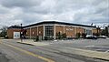
Downtown Findlay
|
|
| Nickname(s):
Flag City, USA
|
|

Findlay, Ohio
Location in Ohio

Findlay, Ohio
Location in the United States
|
|
| Country | United States |
| State | Ohio |
| County | Hancock |
| Area | |
| • Total | 19.74 sq mi (51.21 km2) |
| • Land | 19.64 sq mi (50.87 km2) |
| • Water | 0.13 sq mi (0.34 km2) |
| Elevation | 781 ft (238 m) |
| Population
(2020)
|
|
| • Total | 40,313 |
| • Estimate
(2023)
|
40,139 |
| • Density | 2,052.49/sq mi (792.49/km2) |
| Time zone | UTC-5 (Eastern (EST)) |
| • Summer (DST) | UTC-4 (EDT) |
| ZIP codes |
45839-45840
|
| Area code(s) | 419, 567 |
| FIPS code | 39-27048 |
| GNIS feature ID | 1086245 |
| Website | www.findlayohio.gov |
Findlay (pronounced FIN-lee) is a city in Ohio, United States. It is the main city of Hancock County. Findlay is the second-largest city in Northwest Ohio. It is located about 40 miles (64 km) south of Toledo. In 2020, about 40,313 people lived there.
Findlay is known for being home to the University of Findlay. It is also where Marathon Petroleum, a very large company, has its main office.
Contents
History of Findlay
Early Beginnings
During the War of 1812, a man named Colonel James Findlay built a road and a fort. This fort was called Fort Findlay. It helped protect troops in the Great Black Swamp area. After the war, the community of Findlay started. The first town areas were planned in 1821.
A Stop on the Underground Railroad
Before the Civil War, Findlay was an important stop. It was part of the Underground Railroad. This was a secret network that helped enslaved people find freedom.
Oil Boom and Famous Visitors
In the 1880s, Findlay became a busy center for oil and natural gas. However, the oil supply became much smaller by the early 1900s.
In 1884, Findlay hosted a big music festival. A young cornet player named Warren G. Harding competed there. He later became the 29th President of the United States.
A Song and New Technology
In 1908, a songwriter named Tell Taylor wrote a famous song. It was called "Down by the Old Mill Stream." He wrote it while fishing by the Blanchard River in Findlay.
In the early 1960s, Findlay was special. For three months, it was the only place in the world with touch-tone telephone service. This new phone service started there on November 1, 1960.
Geography of Findlay
Findlay is located at about 41 degrees North and 83 degrees West. The city covers an area of about 19.25 square miles (50 square kilometers). Most of this area is land.
The Blanchard River flows through Findlay. It runs from east to west.
Findlay also has a very large water storage area. It is called the Findlay Reservoir No. 2. It is the biggest above-ground reservoir in Ohio. It can hold about 5 billion gallons of water.
Population of Findlay
How Many People Live Here?
Findlay has grown a lot over the years. In 1830, only 52 people lived here. By 2020, the population was 40,313.
| Historical population | |||
|---|---|---|---|
| Census | Pop. | %± | |
| 1830 | 52 | — | |
| 1840 | 469 | 801.9% | |
| 1850 | 1,256 | 167.8% | |
| 1860 | 2,467 | 96.4% | |
| 1870 | 3,315 | 34.4% | |
| 1880 | 4,633 | 39.8% | |
| 1890 | 18,553 | 300.5% | |
| 1900 | 17,613 | −5.1% | |
| 1910 | 14,858 | −15.6% | |
| 1920 | 17,021 | 14.6% | |
| 1930 | 19,363 | 13.8% | |
| 1940 | 20,228 | 4.5% | |
| 1950 | 23,845 | 17.9% | |
| 1960 | 30,344 | 27.3% | |
| 1970 | 35,800 | 18.0% | |
| 1980 | 35,533 | −0.7% | |
| 1990 | 35,703 | 0.5% | |
| 2000 | 38,967 | 9.1% | |
| 2010 | 41,202 | 5.7% | |
| 2020 | 40,313 | −2.2% | |
| 2023 (est.) | 40,139 | −2.6% | |
| Sources: | |||
People in Findlay (2020)
In 2020, there were 40,313 people living in Findlay. Most people (about 84.6%) were White. About 2.5% were Black, and 2.3% were Asian. People of Hispanic or Latino background made up about 7.9% of the population.
About 20.4% of the people were under 18 years old. About 17.2% were 65 years or older. The city has slightly more females (51.8%) than males (48.2%).
Economy of Findlay
Findlay is home to many important companies.
Major Companies
For a long time, Cooper Tire & Rubber Company had its main office in Findlay. This company makes tires for cars and trucks. In 2021, another company, Goodyear Tire & Rubber Company, bought Cooper Tire.
Marathon Petroleum also has its main office in Findlay. This company deals with oil and gas. It became an independent company in 2011.
The Whirlpool Corporation has a huge dishwasher factory in Findlay. It is thought to be the largest dishwasher plant in the world.
Findlay also has several large distribution centers. These are places where goods are stored and sent out. Companies like Best Buy, Lowe's, and Campbell Soup Company have centers here.
Top Employers
Here are some of the biggest employers in Findlay:
| # | Employer | Number of employees |
|---|---|---|
| 1 | Blanchard Valley Regional Health Center | 3,155 |
| 2 | Marathon Petroleum Corporation | 2,188 |
| 3 | Whirlpool Corporation | 2,186 |
| 4 | Goodyear | 1,066 |
| 5 | Findlay City Schools | 897 |
| 6 | The University of Findlay | 550 |
| 7 | Lowe's Distribution Center | 524 |
| 8 | McLane | 510 |
| 9 | Hancock County | 484 |
| 10 | Ball Metal | 448 |
Culture and Events
Fun Things to Do
Findlay hosts many fun events throughout the year:
- Boogie on Main Street – in June
- Riverside Wine festival – in June
- Flag City BalloonFest – in August
- Rib-Off on Broadway – in August
- Oktoberfest – in September
- Findlay | Hancock County Halloween Parade – in October
Sports in Findlay
Findlay has been home to different sports teams. In the past, there were minor league baseball teams. These teams played between 1895 and 1941. One team, the Findlay Browns, was connected to the St. Louis Browns.
The city also had hockey teams. The Findlay Freedom played from 2006 to 2008. Then, the Findlay Grrrowl played Junior A hockey. In 2009, the Grrrowl won their league championship.
The University of Findlay has college sports teams. They play in Division II athletics. They are part of the Great Midwest Athletic Conference.
Transportation in Findlay
Getting Around
Findlay has an airport called Findlay Airport. However, it does not have regular passenger flights.
Several major highways pass through the city. These include Interstate 75, US 68, and US 224. Other state routes also run through Findlay.
In the past, passenger trains used to travel through Findlay. The last trains stopped running in 1959.
Education in Findlay
Schools for Younger Students
Findlay has schools for younger students. There are three intermediate schools for grades 3-5. There are also three primary schools for kindergarten to grade 2.
For many years, students went to one of three junior high schools. These were Donnell, Central, or Glenwood. New buildings for Donnell and Glenwood opened in 2013. The old Central building was once Findlay's high school. Part of it was made into a new Performing Arts Center.
Findlay High School
Findlay High School is a large high school. It has about 1,632 students in grades 9-12. Many of its teachers have advanced degrees.
Colleges and Universities
Findlay is home to the University of Findlay. This is a private university with over 4,100 students. It is well-known for its programs in Education and equestrian studies. Students studying horses can use the university's large farms.
Owens Community College is also in Findlay. It is a state school with about 2,391 students.
Winebrenner Theological Seminary is another school in Findlay. It is located next to the University of Findlay.
Public Library
The city has the main branch of the Findlay-Hancock County Public Library. The library started in 1888. It moved into an old post office building in 1935. The library building has been updated several times. In 2019, the library stopped charging late fees for books.
Notable People from Findlay
Many interesting people have come from Findlay:
- Peggy Kirk Bell – a famous golfer.
- Willard Harrison Bennett – an inventor.
- Aaron Craft – a college basketball player.
- Gavin Creel – a Tony Award-winning Broadway actor.
- Russel Crouse – a Broadway playwright.
- Jo Ann Davidson – Ohio's first female Speaker of the House.
- Marie Dressler – a famous actress from silent films.
- Ray Harroun – a race car driver and the first Indianapolis 500 winner.
- Grant "Home Run" Johnson – a Negro league baseball player.
- Dave Laut – an Olympic shot-putter.
- Marilyn Miller – a Broadway star from the 1920s.
- Michael G. Oxley – a Congressman.
- Ben Roethlisberger – a former quarterback for the Pittsburgh Steelers in the NFL.
- Tell Taylor – the composer of "Down by the Old Mill Stream".
Friendship City
Findlay has a friendship city agreement with Kawaguchi, Saitama, in Japan. This agreement started on August 16, 2018.
Images for kids
-
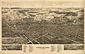
Panoramic map of Findlay (around 1889)
-
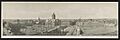
Bird's-eye view of Findlay, around 1906
-
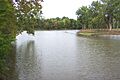
The Blanchard River as seen from Riverside Park in Findlay.
-
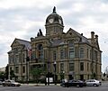
Hancock County Courthouse in Findlay
-
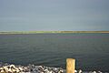
Findlay Reservoir No. 2, the largest above-ground reservoir in the state
-
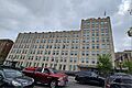
Marathon Petroleum's headquarters in downtown Findlay
-
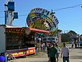
The Hancock County Fair
-
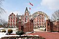
University of Findlay's Old Main
-
The main branch of the Findlay-Hancock County Public Library


.jpg)


See also
 In Spanish: Findlay (Ohio) para niños
