West Monroe, New York facts for kids
Quick facts for kids
West Monroe, New York
|
|
|---|---|

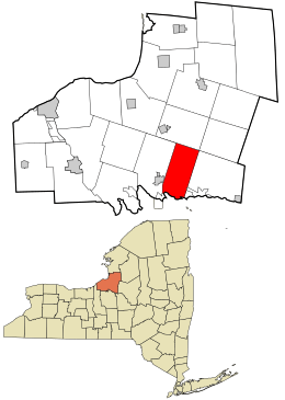
Location in Oswego County and the state of New York.
|
|
| Country | United States |
| State | New York |
| County | Oswego |
| Area | |
| • Total | 38.59 sq mi (99.94 km2) |
| • Land | 33.75 sq mi (87.40 km2) |
| • Water | 4.84 sq mi (12.54 km2) |
| Elevation | 446 ft (136 m) |
| Population
(2010)
|
|
| • Total | 4,252 |
| • Estimate
(2016)
|
4,149 |
| • Density | 122.95/sq mi (47.47/km2) |
| Time zone | UTC-5 (Eastern (EST)) |
| • Summer (DST) | UTC-4 (EDT) |
| ZIP code |
13167
|
| Area code(s) | 315 |
| FIPS code | 36-80500 |
| GNIS feature ID | 0979623 |
West Monroe is a town located in Oswego County, New York, United States. In 2010, about 4,252 people lived there. This town is found in the southeastern part of Oswego County.
People first started settling in the West Monroe area around 1806. Four farmers bought land from George Scriba for a small price per acre. The town itself was officially created on March 21, 1839. It was formed from a part of the town of Constantia. By 1850, West Monroe had 1,197 residents.
Contents
Geography of West Monroe
The town's borders reach into Oneida Lake. The southern edge of the town is located along the high-water mark on the south shore of Oneida Lake.
According to the United States Census Bureau, the town covers a total area of about 38.5 square miles (99.9 square kilometers). Of this, about 33.7 square miles (87.4 square kilometers) is land. The remaining 4.8 square miles (12.5 square kilometers), which is about 12.48% of the total area, is water.
Population and People
| Historical population | |||
|---|---|---|---|
| Census | Pop. | %± | |
| 1840 | 918 | — | |
| 1850 | 1,197 | 30.4% | |
| 1860 | 1,416 | 18.3% | |
| 1870 | 1,304 | −7.9% | |
| 1880 | 1,314 | 0.8% | |
| 1890 | 1,100 | −16.3% | |
| 1900 | 936 | −14.9% | |
| 1910 | 915 | −2.2% | |
| 1920 | 782 | −14.5% | |
| 1930 | 666 | −14.8% | |
| 1940 | 731 | 9.8% | |
| 1950 | 1,002 | 37.1% | |
| 1960 | 1,417 | 41.4% | |
| 1970 | 2,535 | 78.9% | |
| 1980 | 3,482 | 37.4% | |
| 1990 | 4,393 | 26.2% | |
| 2000 | 4,428 | 0.8% | |
| 2010 | 4,252 | −4.0% | |
| 2016 (est.) | 4,149 | −2.4% | |
| U.S. Decennial Census | |||
In 2000, a census showed that 4,428 people lived in West Monroe. These people made up 1,579 households and 1,206 families. The population density was about 131.3 people per square mile (50.7 people per square kilometer).
There were 1,765 homes in the town. On average, there were 52.3 homes per square mile (20.2 homes per square kilometer). Most residents, about 97.38%, were White. Other groups included African American, Native American, and Asian people. About 0.36% of the population was Hispanic or Latino.
About 39.0% of households had children under 18 living with them. Most households, 61.9%, were married couples living together. The average household had 2.80 people, and the average family had 3.16 people.
The population's age was spread out. About 29.2% were under 18 years old. The median age in the town was 35 years. For every 100 females, there were about 108.8 males.
The average income for a household in the town was $42,043. For families, the average income was $47,019. About 11.8% of the population lived below the poverty line. This included 14.7% of those under 18 and 10.8% of those aged 65 or older.
Famous People from West Monroe
West Monroe has been home to some notable individuals:
- Hadwen C. Fuller – He was a former US Congressman.
- Tom Murphy – He is a professional baseball player.
Communities and Places in West Monroe
Here are some of the smaller communities and locations you can find within the town of West Monroe:
- Gulf Bridge
- Little France
- Mallory – This is a small village located on the western border of the town.
- Mud Settlement
- Toad Harbor – This small village is right on the shore of Oneida Lake.
- Union Settlement
- Vorhees Corners – This is a small village on the town line in the northwestern part of the town.
- West Monroe – This is the main community within the town.
- Whig Hill
See also
 In Spanish: West Monroe (Nueva York) para niños
 | Emma Amos |
 | Edward Mitchell Bannister |
 | Larry D. Alexander |
 | Ernie Barnes |

