Franklin County, Idaho facts for kids
Quick facts for kids
Franklin County
|
||
|---|---|---|

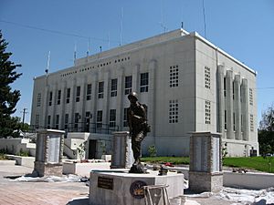
Franklin County Courthouse, Preston
|
||
|
||

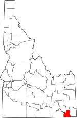
Location within the U.S. state of Idaho
|
||
 Idaho's location within the U.S. |
||
| Country | ||
| State | ||
| Founded | January 20, 1913 | |
| Named for | Franklin D. Richards | |
| Seat | Preston | |
| Largest city | Preston | |
| Area | ||
| • Total | 668 sq mi (1,730 km2) | |
| • Land | 664 sq mi (1,720 km2) | |
| • Water | 4.7 sq mi (12 km2) 0.7% | |
| Population
(2020)
|
||
| • Total | 14,194 | |
| • Estimate
(2023)
|
15,494 |
|
| • Density | 21.249/sq mi (8.204/km2) | |
| Time zone | UTC−7 (Mountain) | |
| • Summer (DST) | UTC−6 (MDT) | |
| Congressional district | 2nd | |
Franklin County is a cool place in the state of Idaho, USA. It's like a big neighborhood with its own government. In 2020, about 14,194 people lived here. The main town and where the county government is located is Preston.
Franklin County was created in 1913. It was named after Franklin D. Richards, who was an important leader in the Church of Jesus Christ of Latter-day Saints. Fun fact: this is the only Franklin County in the United States that is not named after Benjamin Franklin! Franklin County is also part of the larger Logan Metropolitan Area, which includes parts of Utah.
Contents
History of Franklin County
The first permanent settlement by non-native people in Idaho happened right here in Franklin County. On April 14, 1860, a group of people from The Church of Jesus Christ of Latter-day Saints, led by Thomas S. Smart, started a town called Franklin. This was the seventh settlement in the Cache Valley.
At first, people thought Franklin was in Utah. But in 1872, the border between Idaho and Utah was officially set. That's when everyone realized Franklin was actually in Idaho! Other towns in the county were also settled around this time. Oxford was settled in 1864, Weston in 1865, Dayton in 1868, Clifton in 1869, and Preston by 1868.
A sad event called the Bear River Massacre happened in what is now Franklin County on January 29, 1863.
For many years, the county's boundaries changed a lot. It was part of different territories and counties before finally becoming Franklin County in 1913. This made it a bit confusing for the early settlers!
In 1953, a plane carrying 37 soldiers who had served in the Korean War crashed in the mountains of eastern Franklin County. Sadly, everyone on board died. This was the worst plane crash in Idaho's history. A special memorial was built in 1967 to remember them. People in the area call it the Pat Hollow crash site.
Geography of Franklin County
Franklin County covers a total area of about 668 square miles (1,730 square kilometers). Most of this area, about 664 square miles (1,720 square kilometers), is land. The rest, about 4.7 square miles (12 square kilometers), is water.
Neighboring Counties
Franklin County shares its borders with several other counties:
- Oneida County – to the west
- Bannock County – to the northwest
- Caribou County – to the north
- Bear Lake County – to the east
- Cache County, Utah – to the south
Main Roads
These are the important highways that run through Franklin County:
Protected Natural Areas
Parts of these national forests are located in Franklin County:
- Cache National Forest
- Caribou National Forest
People of Franklin County
| Historical population | |||
|---|---|---|---|
| Census | Pop. | %± | |
| 1920 | 8,650 | — | |
| 1930 | 9,379 | 8.4% | |
| 1940 | 10,229 | 9.1% | |
| 1950 | 9,867 | −3.5% | |
| 1960 | 8,467 | −14.2% | |
| 1970 | 7,373 | −12.9% | |
| 1980 | 8,895 | 20.6% | |
| 1990 | 9,232 | 3.8% | |
| 2000 | 11,329 | 22.7% | |
| 2010 | 12,786 | 12.9% | |
| 2020 | 14,194 | 11.0% | |
| 2023 (est.) | 15,494 | 21.2% | |
| U.S. Decennial Census 1790–1960 1900–1990 1990–2000 2010–2020 2020 |
|||
Population in 2010
In 2010, there were 12,786 people living in Franklin County. These people lived in 4,079 homes, and 3,259 of these were families. The county had about 19 people living per square mile.
Most of the people in the county were White (94.4%). A smaller number were American Indian (0.4%), Black (0.2%), or Asian (0.1%). About 3.3% were from other backgrounds, and 1.6% were from two or more backgrounds. About 6.6% of the people were of Hispanic or Latino origin.
Many families had children under 18 living with them (44.1%). Most homes (70.6%) were married couples living together. The average age of people in the county was 31.5 years old.
The average yearly income for a family in the county was about $50,586. About 13.7% of all people in the county lived below the poverty line. This included 20.4% of kids under 18.
Towns and Communities
Franklin County has several towns and smaller communities.
Cities
- Clifton
- Dayton
- Franklin
- Oxford
- Preston (This is the county seat, where the main government offices are.)
- Weston
Smaller Communities (Unincorporated)
These are places that don't have their own city government:
- Mink Creek
- Thatcher
- Whitney
- Fairview
- Riverdale
See also
 In Spanish: Condado de Franklin (Idaho) para niños
 | Dorothy Vaughan |
 | Charles Henry Turner |
 | Hildrus Poindexter |
 | Henry Cecil McBay |


