Caribou County, Idaho facts for kids
Quick facts for kids
Caribou County
|
||
|---|---|---|

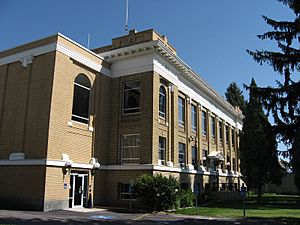
Caribou County Courthouse, Soda Springs
|
||
|
||

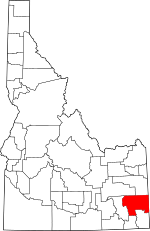
Location within the U.S. state of Idaho
|
||
 Idaho's location within the U.S. |
||
| Country | ||
| State | ||
| Founded | February 11, 1919 | |
| Named for | Caribou Mountains | |
| Seat | Soda Springs | |
| Largest city | Soda Springs | |
| Area | ||
| • Total | 1,799 sq mi (4,660 km2) | |
| • Land | 1,764 sq mi (4,570 km2) | |
| • Water | 34 sq mi (90 km2) 1.9% | |
| Population
(2020)
|
||
| • Total | 7,027 |
|
| • Density | 3.9/sq mi (1.5/km2) | |
| Time zone | UTC−7 (Mountain) | |
| • Summer (DST) | UTC−6 (MDT) | |
| Congressional district | 2nd | |
Caribou County is a county located in the state of Idaho. In 2020, about 7,027 people lived there. The main city and county seat is Soda Springs.
Contents
History
Explorers like Robert Stuart and Donald McKenzie visited the Soda Springs area in the early 1800s. Later, trappers, missionaries, and pioneers traveling the Oregon Trail passed through. The famous springs in Soda Springs were a popular meeting spot for trappers. People wrote about these springs in their journals as early as 1834.
In 1863, a religious group called the Morrisites found safety near Soda Creek and Bear River. They built a town called Morristown. A fort was also built there to protect them. Soda Springs became the first county seat for Oneida County in 1864.
The current town of Soda Springs began in 1871. Brigham Young and other Mormons bought land there. Young often visited his property in the area for fun.
Settlements in the western part of the county, like Thatcher and Chesterfield, were mostly for ranching and farming. Chester Call arrived in 1880, and the towns of Chesterfield and Squaw Creek Station were settled in 1882. Squaw Creek Station later became Bancroft when the railroad was built. The town of Grace started in 1893. While Chesterfield's population went down, Grace and Bancroft continued to grow.
Caribou County was officially created on February 11, 1919. Some areas that are now part of Caribou County were originally part of other counties like Bingham and Bannock. In 1948, residents of a nearby area voted to join Caribou County, making it the size it is today.
Geography
Caribou County covers about 1,799 square miles. Most of this area, about 1,764 square miles, is land. The rest, about 34 square miles, is water. The highest point in the county is Meade Peak, which is about 9,963 feet (3,037 meters) above sea level.
Neighboring Counties
- Bonneville County - to the north
- Lincoln County, Wyoming - to the east
- Bear Lake County - to the south
- Franklin County - to the south
- Bannock County - to the west
- Bingham County - to the northwest
Protected Natural Areas
- Cache National Forest (part of it)
- Caribou National Forest (part of it)
- Grays Lake National Wildlife Refuge (part of it)
Main Roads
Population Facts
| Historical population | |||
|---|---|---|---|
| Census | Pop. | %± | |
| 1920 | 2,191 | — | |
| 1930 | 2,121 | −3.2% | |
| 1940 | 2,284 | 7.7% | |
| 1950 | 5,576 | 144.1% | |
| 1960 | 5,976 | 7.2% | |
| 1970 | 6,534 | 9.3% | |
| 1980 | 8,695 | 33.1% | |
| 1990 | 6,963 | −19.9% | |
| 2000 | 7,304 | 4.9% | |
| 2010 | 6,963 | −4.7% | |
| 2020 | 7,027 | 0.9% | |
| 2023 (est.) | 7,219 | 3.7% | |
| U.S. Decennial Census 1790–1960, 1900–1990, 1990–2000, 2010–2020 2020 |
|||
In 2010, there were 6,963 people living in Caribou County. There were 2,606 households, which are groups of people living together. Most people in the county were white. A small number of people were from other racial backgrounds. About 5% of the population was of Hispanic or Latino origin.
Many families in the county had children under 18 living with them. Most households were married couples. The average age of people in the county was about 37.7 years old.
Communities
Cities
Unincorporated Communities
See also
 In Spanish: Condado de Caribou para niños
 | Lonnie Johnson |
 | Granville Woods |
 | Lewis Howard Latimer |
 | James West |


