
Cache County, Utah facts for kids
Quick facts for kids
Cache County
|
|
|---|---|

Cache County Courthouse, July 2009
|
|

Location within the U.S. state of Utah
|
|
 Utah's location within the U.S. |
|
| Country | |
| State | |
| Founded | January 5, 1856 (created) April 4, 1857 (organized) |
| Named for | Fur trade |
| Seat | Logan |
| Largest city | Logan |
| Area | |
| • Total | 1,173 sq mi (3,040 km2) |
| • Land | 1,165 sq mi (3,020 km2) |
| • Water | 8.2 sq mi (21 km2) 0.7% |
| Population
(2020)
|
|
| • Total | 133,154 |
| • Density | 113.52/sq mi (43.829/km2) |
| Time zone | UTC−7 (Mountain) |
| • Summer (DST) | UTC−6 (MDT) |
| Congressional district | 1st |
Cache County (pronounced KASH) is a county in northern Utah, right next to Idaho. In 2020, about 133,154 people lived here. The biggest city and the main government center is Logan. Cache County is part of the larger Logan metropolitan area, which also includes Franklin County in Idaho.
Contents
History
People have lived in the valleys of Cache County for a very long time, even as far back as 10,000 BCE. More recently, the valley was home to the Plains Indians and the Shoshone people.
Explorers and fur trappers started visiting the area in the late 1700s and early 1800s. Famous explorers like John Henry Weber and Jim Bridger came through in 1824. Others, like Peter Skene Ogden and James Beckwourth, followed in 1825.
In July 1855, a group of settlers from the LDS Church brought cattle into the valley. They camped at Haw Bush Spring, which is now Elkhorn Ranch. But the winter was very cold, so they went back to the Salt Lake Valley.
Brigham Young, a leader of the LDS Church, asked Peter Maughan to start a new settlement in Cache Valley. Maughan had asked for better land for farming families. On September 15, 1856, he started Maughan's Fort, which is now Wellsville. More settlers arrived, and by 1859, new towns like Providence, Mendon, Logan, Richmond, and Smithfield were created.
The Utah Territory government officially created Cache County on January 5, 1856. The county government was fully set up by April 4, 1857, and Logan became the main city. The county was named after the "caches" (pronounced KASH-ez), which were hidden stashes of furs left by trappers.
The county's borders changed a few times. In 1863, some parts of Cache County became part of the new Idaho Territory. Then, in 1864, the eastern part of the county was separated to form Rich County. Cache County's borders have stayed the same since 1864.
A railroad line was built between Brigham City and Logan in 1873. This line later connected to the transcontinental railroad, which helped Cache County grow. Farmers could now send their crops, especially grain and dairy products, to markets all over the country. The number of sheep in the county also grew a lot, from 10,000 in 1880 to 300,000 by 1900! Later, the Forest Service started regulating grazing, which helped manage the sheep population.
By 1910, Cache County had 16,000 dairy cows. This led to the creation of creameries, flour mills, and clothing factories. Today, Cache County is still a top producer of dairy products in Utah, and it also grows a lot of hay, alfalfa, and grain.
Geography
Cache County is located in the northern part of Utah, right on the border with Idaho. On the west side of the county are the Wellsville Mountains, and on the east side are the Bear River Mountains. Both are northern parts of the Wasatch Range. The flat area in between is called the Cache Valley, which extends north into Idaho.
The highest point in Cache County is Naomi Peak, which is about 9,979 feet (3,042 meters) above sea level. The Bear River flows through Cache Valley. The county covers a total area of about 1,173 square miles (3,038 square kilometers). Most of this is land, with a small amount of water.
Major Roads
- U.S. Highway 89
- U.S. Highway 91
- State Route 23
- State Route 30
- State Route 101
- State Route 142
- State Route 165
- State Route 200
- State Route 218
- State Route 252
Neighboring Counties
- Oneida County, Idaho - northwest
- Franklin County, Idaho - north
- Bear Lake County, Idaho - northeast
- Rich County - east
- Weber County - south
- Box Elder County - west
Protected Natural Areas
- Cache National Forest (part)
- Caribou National Forest (part)
- Hardware Ranch Wildlife Management Area (a state park)
- Tony Grove Lake Campground (managed by the U.S. Forest Service)
- Millville Face Wildlife Management Area
Lakes and Reservoirs
- Crescent Lake
- Cutler Reservoir
- Hyrum Reservoir
- Newton Reservoir
- Porcupine Reservoir
- Tony Grove Lake
Population and People
| Historical population | |||
|---|---|---|---|
| Census | Pop. | %± | |
| 1890 | 15,509 | — | |
| 1900 | 18,139 | 17.0% | |
| 1910 | 23,062 | 27.1% | |
| 1920 | 26,992 | 17.0% | |
| 1930 | 27,424 | 1.6% | |
| 1940 | 29,797 | 8.7% | |
| 1950 | 33,536 | 12.5% | |
| 1960 | 35,788 | 6.7% | |
| 1970 | 42,331 | 18.3% | |
| 1980 | 57,176 | 35.1% | |
| 1990 | 70,183 | 22.7% | |
| 2000 | 91,391 | 30.2% | |
| 2010 | 112,656 | 23.3% | |
| 2020 | 133,154 | 18.2% | |
| 2022 (est.) | 140,173 | 24.4% | |
| US Decennial Census 1790–1960 1900–1990 1990–2000 2010–2018 2019 2020 |
|||
In 2020, Cache County had 133,154 people. This means there were about 114 people for every square mile. Most people (about 82%) were White. About 11% of the population was Hispanic or Latino.
The median age in Cache County was 26.3 years old, which means half the people were younger than 26.3 and half were older. About 29% of the population was under 18 years old.
There were about 41,658 households in the county. A household is a group of people living together. The average household had 3.2 people. About 74% of households were families. Many households (about 40%) had children under 18 living in them.
The average income for a household in Cache County was about $60,530 per year. About 14.6% of the population lived below the poverty line.
When it comes to education, about 6.5% of adults (25 or older) had not finished high school. However, many people had higher education: about 35% had some college or an associate degree, and about 38% had a bachelor's or graduate degree.
Communities

Cache County has many different communities, including 13 cities and six towns. Millville was the first area to become an official city in April 1864. Logan became a city in January 1866, and Wellsville followed two days later. The newest town to become official was Amalga in 1938.
Many cities and areas in Cache County have annual celebrations. Millville's "May Day" has been celebrated since 1862, making it the oldest celebration in the valley. Richmond's "Black & White Days" includes the nation's longest-running dairy show, which started in 1912. The county government also hosts the Cache County Fair and Rodeo. Logan has about 24 events each year, like food festivals and historic home tours.
Cities (13)
- Hyde Park
- Hyrum
- Lewiston
- Logan (county seat)
- Mendon
- Millville
- Nibley
- North Logan
- Providence
- Richmond
- River Heights
- Smithfield
- Wellsville
Towns (6)
Townships (1)
- College-Young (a combination of College Ward and Young Ward)
Census-Designated Places (5)
These are areas that are not officially cities or towns but are recognized for census purposes.
- Avon
- Benson
- Cache (also known as Cache Junction)
- Cove
- Petersboro
Former Communities (2)
- La Plata
- White Horse Village
Education
School Districts
- Cache County School District
- Logan City School District
Universities and Colleges
- Utah State University (a public university)
- Bridgerland Technical College (a public technical college)
Gallery
-
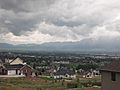
Cache Valley looking south from North Logan
-
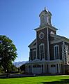
The Logan Tabernacle in Logan

.jpg)
See also
 In Spanish: Condado de Cache para niños
