Lewiston, Utah facts for kids
Quick facts for kids
Lewiston, Utah
|
|
|---|---|

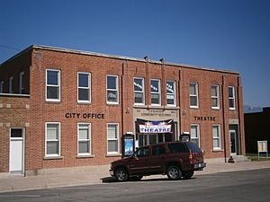
The Lewiston Community Building, built in 1935, is listed on the National Register of Historic Places.
|
|

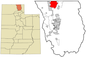
Location in Cache County and the state of Utah
|
|
| Country | United States |
| State | Utah |
| County | Cache |
| Settled | 1870 |
| Named for | William H. Lewis |
| Area | |
| • Total | 25.90 sq mi (67.09 km2) |
| • Land | 25.84 sq mi (66.93 km2) |
| • Water | 0.06 sq mi (0.16 km2) |
| Elevation | 4,505 ft (1,373 m) |
| Population
(2020)
|
|
| • Total | 1,939 |
| • Density | 69.58/sq mi (26.86/km2) |
| Time zone | UTC-7 (Mountain (MST)) |
| • Summer (DST) | UTC-6 (MDT) |
| ZIP code |
84320
|
| Area code(s) | 435 |
| FIPS code | 49-44760 |
| GNIS feature ID | 2410826 |
Lewiston is a city in Cache County, Utah, United States. It is located right on Utah's northern border, next to Idaho. In 2020, about 1,939 people lived there. Lewiston is part of the larger Logan area, which includes parts of Utah and Idaho.
Contents
Geography of Lewiston
Lewiston covers about 25.7 square miles (66.5 square kilometers). Most of this area is land. Only a very small part, about 0.1 square miles (0.3 square kilometers), is water.
Lewiston's Climate
Lewiston has a type of weather called a humid continental climate. This means the city experiences big changes in temperature throughout the year. Summers are usually warm to hot, and sometimes humid. Winters are cold, and can even be very cold.
People of Lewiston
| Historical population | |||
|---|---|---|---|
| Census | Pop. | %± | |
| 1880 | 525 | — | |
| 1890 | 754 | 43.6% | |
| 1900 | 995 | 32.0% | |
| 1910 | 989 | −0.6% | |
| 1920 | 1,646 | 66.4% | |
| 1930 | 1,783 | 8.3% | |
| 1940 | 1,804 | 1.2% | |
| 1950 | 1,533 | −15.0% | |
| 1960 | 1,336 | −12.9% | |
| 1970 | 1,244 | −6.9% | |
| 1980 | 1,438 | 15.6% | |
| 1990 | 1,532 | 6.5% | |
| 2000 | 1,877 | 22.5% | |
| 2010 | 1,766 | −5.9% | |
| 2020 | 1,939 | 9.8% | |
| U.S. Decennial Census | |||
In 2000, there were 1,877 people living in Lewiston. They lived in 531 households, with 446 of those being families. The city had about 73 people per square mile. Most of the people were White (94.67%). A smaller number were from other racial backgrounds. About 6.29% of the population was Hispanic or Latino.
Many households (53.3%) had children under 18 living there. Most households (75.0%) were married couples. The average household had about 3.53 people. The average family had about 3.94 people.
The population of Lewiston is quite young. About 39.4% of the people were under 18 years old. The average age in the city was 24 years. For every 100 females, there were about 101 males.
In 2000, the average income for a household in Lewiston was $36,417. For families, the average income was $41,705. About 10.2% of all people in Lewiston lived below the poverty line. This included 12.2% of those under 18.
Notable People from Lewiston
- Glen Laird Taggart: He was the 11th president of Utah State University.
See also
 In Spanish: Lewiston (Utah) para niños
 | Janet Taylor Pickett |
 | Synthia Saint James |
 | Howardena Pindell |
 | Faith Ringgold |

