
Rich County, Utah facts for kids
Quick facts for kids
Rich County
|
|
|---|---|

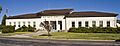
Rich County Courthouse, Randolph
|
|

Location within the U.S. state of Utah
|
|
 Utah's location within the U.S. |
|
| Country | |
| State | |
| Founded | January 16, 1864 (created) May 5, 1864 (organized) |
| Named for | Charles C. Rich |
| Seat | Randolph |
| Largest town | Garden City |
| Area | |
| • Total | 1,086 sq mi (2,810 km2) |
| • Land | 1,029 sq mi (2,670 km2) |
| • Water | 58 sq mi (150 km2) 5.3% |
| Population
(2020)
|
|
| • Total | 2,510 |
| • Density | 2.4/sq mi (0.9/km2) |
| Time zone | UTC−7 (Mountain) |
| • Summer (DST) | UTC−6 (MDT) |
| Congressional district | 1st |

Rich County is a county located in the state of Utah in the United States. In 2020, about 2,510 people lived here. This makes it the third smallest county in Utah by population. The main town, called the county seat, is Randolph. The biggest town in the county is Garden City. Rich County was officially created in 1864. It was named after Charles C. Rich, an important early leader of the LDS Church.
The southern part of Bear Lake and its valley are in the northern part of the county. The Bear River Valley covers most of the eastern area. These valleys are about 6,000 feet (1,829 meters) high. The rest of the county has mountains, including the Bear River Range. Because it is so high up, the weather is very cold in winter and mild in summer. This is why not many people live here.
Contents
History of Rich County
Rich County has a long and interesting history. People have lived in this area for thousands of years.
Early Native American Life
Many different Native American peoples lived in the Rich County area for a very long time. For example, there is a special place near Woodruff, Utah where ancient people used to hunt bison by making them jump off a cliff.
Spanish and Mexican Claims
From the 1500s, the Spanish Empire claimed all of modern-day Utah, including Rich County. This area was part of a larger region called Alta California. Later, it became part of Mexico. However, neither the Spanish nor the Mexicans had a big or lasting presence in this specific area. In 1848, after a war, the Treaty of Guadalupe Hidalgo gave control of the region to the United States.
First European Explorers
The first explorers of European descent likely visited Rich County in 1811. A trapper named Joseph Miller found the Bear River that year. In 1827, trappers held their first yearly meeting, called a rendezvous, on the south shore of Bear Lake. This tradition is still celebrated today. The spot is now part of Bear Lake State Park. The Oregon Trail, a popular route for pioneers heading to the Northwest Territories, also passed through the northern part of what would become Rich County.
Mormon Settlement and County Creation
Mormon pioneers first settled in the Utah Territory in 1847. But no Mormons moved to the Rich County area permanently until after 1862. That year, the U.S. Congress passed the Homestead Act. This law made land available for people to settle. Brigham Young, a leader of the Mormon pioneers, wanted his people to settle the area. He worried that others would move in if Mormons didn't.
The first settlement within the county's current borders was Round Valley in 1863. It is now a ghost town and was located southwest of Laketown, which was settled in 1864. Randolph was settled in 1870. The county was first named Richland County on January 16, 1864. Its name was shortened to Rich on January 29, 1868. The county's original borders were much larger, reaching into parts of Wyoming and Idaho. However, these areas were later given to other territories and states. The county's current building in Randolph was built in 1940.
Geography and Nature
Rich County is in the very top northeastern corner of Utah. Its northern border touches Idaho, and its eastern border touches Wyoming.
Land and Water
The Bear River flows east out of the middle of the county into Wyoming. The land is very rugged, meaning it has rough, uneven terrain. Less than ten percent of the county's land is used for farming. More than half of the county is used for raising cattle. The land slopes down from the Bear River Mountain peaks in the west towards the east. The highest point is Bridger Peak, which is 9,255 feet (2,821 meters) above sea level. The county covers a total area of 1,086 square miles (2,813 square kilometers). About 1,029 square miles (2,665 square kilometers) is land, and 58 square miles (150 square kilometers) is water.
Valleys and Climate
The Bear River Valley is in the east-central part of the county. The towns of Randolph and Woodruff are in this valley, where farming is important. Because it is so high up, this area is one of the coldest in Utah. Woodruff has even recorded a temperature of -50°F (-46°C)! Temperatures rarely go above 90°F (32°C) in the summer. There is a lot of snow in late autumn, winter, and early spring, and it stays on the ground all winter.
Further north is the southern half of Bear Lake Valley, which includes Bear Lake. This lake is famous for its deep blue water, sandy beaches, and the mountains around it. The Bear River Mountains are on the western side of the county. Logan Canyon is west of Garden City, a charming town that attracts tourists and sits on the western edge of Bear Lake. Laketown is at the southern end of the lake. Three parts of the lake's shoreline are protected by Bear Lake State Park. The eastern slopes of the Bear River Range are becoming a popular place for cabins.
In both major valleys, a weather event called a temperature inversion can be a problem in winter. This is when cold air gets trapped under warmer air. It can bring very cold temperatures, fog, smog, and haze to the valleys for weeks at a time.
Major Roads
- U.S. Route 89 comes down from the Bear River Mountains through Logan Canyon. It then turns north at Garden City and follows the Bear Lake shoreline.
- State Route 16 goes south from Sage Creek Junction through Randolph and Woodruff. It then enters Wyoming.
- State Route 30 goes south from Garden City through Laketown. It then climbs east through the mountains to the Wyoming border.
- State Route 39 goes west from Woodruff into the Wasatch Range towards Huntsville and Ogden. However, this road closes in the mountains during winter because of heavy snow.
- Interstate 80 is near the Rich County border in Summit County. You can only reach it from Rich County by going through Wyoming.
Neighboring Counties
- Bear Lake County, Idaho - north
- Lincoln County, Wyoming - northeast
- Uinta County, Wyoming - southeast
- Summit County - south
- Morgan County - southwest
- Weber County - west
- Cache County - west
- Franklin County, Idaho - northwest
Protected Natural Areas
- Cache National Forest (part of it)
- Bear Lake State Park
- Rendezvous Beach State Park
- Bear Lake Marina State Park
- East Side State Park
Population and People
| Historical population | |||
|---|---|---|---|
| Census | Pop. | %± | |
| 1870 | 1,955 | — | |
| 1880 | 1,263 | −35.4% | |
| 1890 | 1,527 | 20.9% | |
| 1900 | 1,946 | 27.4% | |
| 1910 | 1,883 | −3.2% | |
| 1920 | 1,890 | 0.4% | |
| 1930 | 1,873 | −0.9% | |
| 1940 | 2,028 | 8.3% | |
| 1950 | 1,673 | −17.5% | |
| 1960 | 1,685 | 0.7% | |
| 1970 | 1,615 | −4.2% | |
| 1980 | 2,100 | 30.0% | |
| 1990 | 1,725 | −17.9% | |
| 2000 | 1,961 | 13.7% | |
| 2010 | 2,264 | 15.5% | |
| 2020 | 2,510 | 10.9% | |
| US Decennial Census 1790–1960 1900–1990 1990–2000 2010 2020 |
|||
Quick Facts from the 2020 Census
In 2020, there were 2,510 people living in Rich County. The population density was about 2.4 people per square mile. Most people (92.8%) were White. About 3.9% of the people were Hispanic or Latino.
There were slightly more males (52.15%) than females (47.85%). About 30.6% of the population was under 18 years old. The average age was 38.0 years.
There were 886 households in the county. Most of these (74.5%) were families. About 65.1% of families were married couples. Most households (80.1%) owned their homes, while 19.9% rented.
The average income for a household in Rich County was $63,917. For families, the average income was $73,819. About 10.5% of the population lived below the poverty line.
When it comes to education, most adults (25 years or older) had at least a high school diploma (95.7%). Many had some college education or a degree.
Ancestry of Residents
In 2010, the largest groups of people based on where their families came from were:
- 40.7% English
- 14.2% German
- 10.2% Scottish
- 8.5% "American"
- 5.8% Irish
- 5.6% Danish
Communities in Rich County

Towns
- Garden City
- Laketown (was once called "Last Chance")
- Randolph (This is the county seat, where the main county offices are)
- Woodruff
Other Communities
- Garden (This is a census-designated place, meaning it's a community that's not officially a town but has a defined area for census purposes.)
Ghost Towns
- Argyle
- Pickelville (This used to be a town but was joined with Garden City in 1979.)
Images for kids
-
Rich County Courthouse, Randolph
See also
 In Spanish: Condado de Rich para niños
