Uinta County, Wyoming facts for kids
Quick facts for kids
Uinta County
|
||
|---|---|---|

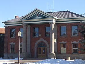
Uinta County Courthouse
|
||
|
||

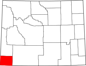
Location within the U.S. state of Wyoming
|
||
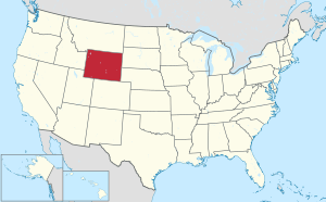
 Wyoming's location within the U.S. |
||
| Country | ||
| State | ||
| Founded | December 1, 1869 | |
| Named for | Uinta Mountains | |
| Seat | Evanston | |
| Largest city | Evanston | |
| Area | ||
| • Total | 2,088 sq mi (5,410 km2) | |
| • Land | 2,081 sq mi (5,390 km2) | |
| • Water | 6.3 sq mi (16 km2) 0.3%% | |
| Population
(2020)
|
||
| • Total | 20,450 | |
| • Density | 9.794/sq mi (3.7815/km2) | |
| Time zone | UTC−7 (Mountain) | |
| • Summer (DST) | UTC−6 (MDT) | |
| Congressional district | At-large | |
Uinta County (/juːˈɪntə/ yoo-IN-tə) is a county in the U.S. state of Wyoming. In 2020, about 20,450 people lived here. Its main city and government center is Evanston. The county shares its southern and western borders with the state of Utah.
Uinta County and Rich County, Utah together form the Evanston, WY-UT Micropolitan Statistical Area. This means they are a small city area with strong economic ties.
Contents
History of Uinta County
Uinta County was created on December 1, 1869. This happened when the government of the Wyoming Territory decided to form it. Its first temporary main city was Fort Bridger.

When it was first made, Uinta County covered the entire western edge of Wyoming. This even included the area where Yellowstone National Park is now. The county got its name from the Uinta Mountains in Utah. You can see these mountains from many places in the county. Uinta County got its current shape in 1911. This was when Lincoln County was created from its northern part.
Geography of Uinta County
Uinta County covers a total area of about 2,088 square miles. Most of this area, about 2,081 square miles, is land. Only a small part, about 6.3 square miles, is water. This makes it the second-smallest county in Wyoming by land area.
Geology and Land Features
The western part of North America has a wide area of folded and pushed-up rock layers. This area stretches from Alaska all the way to Mexico. In southwest Wyoming, including Uinta County, this process created several long faults. These faults formed over millions of years, from the Late Jurassic to the early Eocene periods.
One important discovery happened in 1977 at the Painter Reservoir Field. Oil was found in a thick layer of sandstone. This sandstone forms a special trap for oil, about 3 kilometers deep underground.
Protected Natural Areas
- Wasatch National Forest (part of it is in Uinta County)
State Parks and Historic Sites
- Fort Bridger State Historic Site - A historic fort where you can learn about the past.
- Bear River State Park - A lovely park along the Bear River.
Main Roads in Uinta County
 - Interstate 80 - A major highway that crosses the county.
 - U.S. Highway 189 - Another important road for travel.
Neighboring Counties
- Lincoln County - To the north
- Rich County, Utah - To the west
- Summit County, Utah - To the south and southwest
- Sweetwater County - To the east
People of Uinta County
| Historical population | |||
|---|---|---|---|
| Census | Pop. | %± | |
| 1870 | 856 | — | |
| 1880 | 2,879 | 236.3% | |
| 1890 | 7,414 | 157.5% | |
| 1900 | 12,223 | 64.9% | |
| 1910 | 16,982 | 38.9% | |
| 1920 | 6,611 | −61.1% | |
| 1930 | 6,572 | −0.6% | |
| 1940 | 7,223 | 9.9% | |
| 1950 | 7,331 | 1.5% | |
| 1960 | 7,484 | 2.1% | |
| 1970 | 7,100 | −5.1% | |
| 1980 | 13,021 | 83.4% | |
| 1990 | 18,705 | 43.7% | |
| 2000 | 19,742 | 5.5% | |
| 2010 | 21,118 | 7.0% | |
| 2020 | 20,450 | −3.2% | |
| 2023 (est.) | 20,745 | −1.8% | |
| US Decennial Census 1870–2000 2010–2016 2020 |
|||
Ancestry Groups in Uinta County (2016)
In 2016, people in Uinta County reported their family backgrounds. The largest groups were:
| Largest ancestries (2015) | Percent |
|---|---|
| English |
28.3% |
| German |
18.9% |
| Irish |
8.1% |
| American |
5.6% |
| Scottish |
5.4% |
| Italian |
3.8% |
| Swedish |
4.1% |
| French (except Basque) |
3.3% |
| Dutch |
3.2% |
| Norwegian |
3.0% |
| Danish |
2.5% |
| Welsh |
2.2% |
Uinta County in 2010
In 2010, there were 21,118 people living in Uinta County. There were 7,668 households, which are groups of people living together. About 5,577 of these were families. On average, there were about 10 people per square mile.
Most people in the county were white (92.4%). Other groups included American Indian (0.8%), Black or African American (0.3%), and Asian (0.3%). About 8.8% of the people were of Hispanic or Latino background.
Many people had roots from different countries. The largest ancestry groups were English (33.4%), German (23.0%), and Irish (12.0%).
In 2010, about 39.8% of households had children under 18 living there. Most households (58.3%) were married couples. The average age of people in the county was 33.9 years old.
The average income for a household was $58,346 per year. For families, it was $68,949. About 12.1% of all people in the county lived below the poverty line. This included 14.6% of those under 18.
Religion in Uinta County
Religion in Uinta County, according to ARDA (2020) [1] LDS Church (49.5%) Evangelical Churches (7.7%) Mainline Protestant Churches (1.4%) Black Protestant Churches (1%) Catholic Church (2%) Others (0.6%) None* (37.8%)
Most people in Uinta County consider themselves Christian. In 2020, a little less than half of the people belonged to The Church of Jesus Christ of Latter-day Saints.
About 37% of residents are listed as "Nones." This group includes people who don't belong to a specific religion. However, many of them still have spiritual beliefs. For example, most "Nones" in America believe in God or a Higher Power.
Communities in Uinta County
Cities
- Evanston (This is the main city and where the county government is located.)
Towns
- Bear River
- Lyman
- Mountain View
Small Unincorporated Communities
These are small places that are not officially towns or cities.
- Aspen
- Millburne
- Robertson
Ghost Towns
These are towns that used to exist but are now mostly empty or abandoned.
- Almy
- Bear River City
- Fort Supply
- Piedmont
Census-Designated Places
These are areas that are identified by the U.S. Census Bureau for statistical purposes. They are like small communities but are not officially incorporated as towns.
See also
 In Spanish: Condado de Uinta (Wyoming) para niños
 | Madam C. J. Walker |
 | Janet Emerson Bashen |
 | Annie Turnbo Malone |
 | Maggie L. Walker |


