
Burley, Idaho facts for kids
Quick facts for kids
Burley, Idaho
|
|
|---|---|

Cassia County Courthouse
|
|

Location in Cassia County and Minidoka County, Idaho
|
|

Burley, Idaho
Location in the United States
|
|
| Country | United States |
| State | Idaho |
| Counties | Cassia, Minidoka |
| Area | |
| • Total | 7.00 sq mi (18.1 km2) |
| • Land | 6.67 sq mi (17.3 km2) |
| • Water | 0.33 sq mi (0.9 km2) |
| Elevation | 4,160 ft (1,270 m) |
| Population
(2020)
|
|
| • Total | 11,704 |
| • Density | 1,753.9/sq mi (677.2/km2) |
| Time zone | UTC−7 (Mountain (MST)) |
| • Summer (DST) | UTC−6 (MDT) |
| ZIP code |
83318
|
| Area code(s) | 208 |
| FIPS code | 16-11260 |
| GNIS feature ID | 2409944 |
Burley is a city in southern Idaho, United States. It is located in both Cassia and Minidoka counties. In 2020, about 11,704 people lived there. Burley is the main city in the "Mini-Cassia" area, which includes Cassia and Minidoka counties. It is also the third-largest city in Idaho's Magic Valley region. Burley is the county seat for Cassia County.
Contents
History of Burley
The first people to live in the Burley area were Paleo-Indians about 15,000 to 16,000 years ago. Later, the Northern Shoshone and Northern Paiute tribes lived here.
The famous Oregon Trail passed right through where Burley is today. The California Trail was just south of it, near the City of Rocks National Reserve. In the late 1800s, the Oregon Short Line Railroad was built through Burley, following the Oregon Trail.
A post office opened in Burley in 1905. The town was named after David Ellsworth Burley, who was a local railroad agent. Burley became an official city in 1909. It became the main city for Cassia County in 1918.
In 1984, the Lower Goose Creek Reservoir (Oakley Reservoir) almost overflowed. This happened after a lot of rain and snow. Burley was at risk of flooding if the dam broke. To prevent this, hundreds of local volunteers and the Army Corps of Engineers worked together. In just four days, they dug a 17-mile long, 70-foot wide channel to safely release the water. News programs like The MacNeil/Lehrer NewsHour and The Washington Post reported on this event.
A Simplot potato factory in nearby Heyburn was a big part of the local economy. It opened in 1960 and closed in 2003, employing about 650 people. After it closed, the city of Burley took over the property. Now, it is an industrial park. To help the economy, voters in Burley, Rupert, and Heyburn approved plans to improve their wastewater systems. This helped other food processing companies come to the area, which made the local economy stronger.
Burley's Economy
Farming and food processing are very important to Burley's economy. Burley is in the Magic Valley region, which is known for its dairy farms and crops.
- McCain Foods: This company makes frozen potato products and has a factory in Burley.
- Amalgamated Sugar Company: This company processes sugar beets. Its plant is near Paul.
- Dot Foods: This company has a distribution center in Burley.
- High Desert Milk: This local company is a top dairy processor in Idaho. In 2021, they expanded their Burley facility.
- Suntado: This local business built a new factory in Burley around 2023. It makes shelf-stable milk, which means it can be stored for a long time without refrigeration.
Banking is another major part of Burley's economy. D. L. Evans Bank, a large regional bank, has its main office in Burley. Other banks like Key Bank, Zions Bank, US Bank, Idaho Central Credit Union, First Federal Savings Bank, and Wells Fargo also have offices here.
The city also owns and runs the Burley Municipal Airport. There have been talks about building a new airport because the current one has some issues.
Geography of Burley
Most of Burley is in Cassia County. A small part of the city reaches north into Minidoka County. The Snake River forms the border between these two counties. On the north side of the river, Burley is next to the city of Heyburn on its east side.
Several important roads pass through or near Burley:
- U.S. Route 30: This road goes east-west through the center of Burley. It leads northeast to Interstate 84 in Heyburn. To the west, it goes about 33 miles to Kimberly.
- Idaho State Highway 27: This highway also goes through the center of Burley. It leads north about 5 miles to Paul and south about 21 miles to Oakley.
- State Highway 81: This road goes east from Burley about 9 miles to Declo.
- I-84: This major highway passes through the northern part of Burley. It goes west about 37 miles to the Twin Falls area. To the southeast, it goes about 145 miles to Ogden, Utah. New upgrades to the I-84 exits near Burley and Heyburn are being built and should be finished around 2026.
Burley covers a total area of about 7.0 square miles. About 6.7 square miles are land, and 0.3 square miles are water, which is part of the Snake River.
Burley's Climate
Burley has a semi-arid climate. This means it has cold winters and hot, dry summers. The hottest temperature ever recorded in Burley was 107°F on July 30, 2000. The coldest temperature was -30°F, recorded on January 29, 1949, and January 22, 1962.
The average wind speeds in Burley change throughout the year. They are highest in February, around 9.1 miles per hour. They are lowest in August, around 7.5 miles per hour.
| Climate data for Burley, Idaho (Burley Municipal Airport), 1991–2020 normals, extremes 1948–present | |||||||||||||
|---|---|---|---|---|---|---|---|---|---|---|---|---|---|
| Month | Jan | Feb | Mar | Apr | May | Jun | Jul | Aug | Sep | Oct | Nov | Dec | Year |
| Record high °F (°C) | 64 (18) |
72 (22) |
78 (26) |
89 (32) |
97 (36) |
102 (39) |
107 (42) |
105 (41) |
98 (37) |
91 (33) |
79 (26) |
65 (18) |
107 (42) |
| Mean maximum °F (°C) | 51.7 (10.9) |
57.2 (14.0) |
70.2 (21.2) |
78.9 (26.1) |
86.7 (30.4) |
93.6 (34.2) |
99.4 (37.4) |
97.9 (36.6) |
91.8 (33.2) |
81.4 (27.4) |
66.3 (19.1) |
53.6 (12.0) |
100.3 (37.9) |
| Mean daily maximum °F (°C) | 37.4 (3.0) |
42.7 (5.9) |
53.0 (11.7) |
59.5 (15.3) |
69.1 (20.6) |
78.0 (25.6) |
87.9 (31.1) |
86.7 (30.4) |
76.6 (24.8) |
62.6 (17.0) |
48.2 (9.0) |
37.3 (2.9) |
61.6 (16.4) |
| Daily mean °F (°C) | 29.2 (−1.6) |
33.3 (0.7) |
41.4 (5.2) |
47.1 (8.4) |
55.8 (13.2) |
63.4 (17.4) |
71.5 (21.9) |
69.9 (21.1) |
60.8 (16.0) |
49.1 (9.5) |
37.6 (3.1) |
29.2 (−1.6) |
49.0 (9.4) |
| Mean daily minimum °F (°C) | 21.0 (−6.1) |
23.9 (−4.5) |
29.9 (−1.2) |
34.8 (1.6) |
42.6 (5.9) |
48.8 (9.3) |
55.1 (12.8) |
53.1 (11.7) |
45.0 (7.2) |
35.7 (2.1) |
26.9 (−2.8) |
21.0 (−6.1) |
36.5 (2.5) |
| Mean minimum °F (°C) | 2.1 (−16.6) |
8.1 (−13.3) |
17.6 (−8.0) |
23.4 (−4.8) |
30.6 (−0.8) |
37.8 (3.2) |
45.6 (7.6) |
42.4 (5.8) |
33.6 (0.9) |
21.4 (−5.9) |
10.5 (−11.9) |
2.4 (−16.4) |
−3.4 (−19.7) |
| Record low °F (°C) | −30 (−34) |
−26 (−32) |
−3 (−19) |
12 (−11) |
19 (−7) |
29 (−2) |
33 (1) |
31 (−1) |
18 (−8) |
6 (−14) |
−14 (−26) |
−23 (−31) |
−30 (−34) |
| Average precipitation inches (mm) | 1.05 (27) |
0.69 (18) |
1.02 (26) |
1.09 (28) |
1.69 (43) |
0.78 (20) |
0.26 (6.6) |
0.40 (10) |
0.66 (17) |
0.80 (20) |
0.80 (20) |
1.06 (27) |
10.30 (262) |
| Average snowfall inches (cm) | 6.2 (16) |
4.3 (11) |
1.7 (4.3) |
0.8 (2.0) |
0.0 (0.0) |
0.0 (0.0) |
0.0 (0.0) |
0.0 (0.0) |
0.0 (0.0) |
0.3 (0.76) |
3.0 (7.6) |
6.7 (17) |
23 (58.66) |
| Average precipitation days (≥ 0.01 in) | 9.2 | 7.2 | 8.2 | 9.2 | 8.9 | 5.1 | 2.8 | 3.6 | 3.9 | 5.8 | 7.3 | 9.1 | 80.3 |
| Average snowy days (≥ 0.1 in) | 5.7 | 3.6 | 1.2 | 0.9 | 0.0 | 0.0 | 0.0 | 0.0 | 0.0 | 0.5 | 3.0 | 4.9 | 19.8 |
| Source 1: National Weather Service | |||||||||||||
| Source 2: NOAA (average snowfall/snowy days 1981–2010) | |||||||||||||
People of Burley (Demographics)
| Historical population | |||
|---|---|---|---|
| Census | Pop. | %± | |
| 1920 | 5,408 | — | |
| 1930 | 3,826 | −29.3% | |
| 1940 | 5,329 | 39.3% | |
| 1950 | 5,924 | 11.2% | |
| 1960 | 7,508 | 26.7% | |
| 1970 | 8,279 | 10.3% | |
| 1980 | 8,761 | 5.8% | |
| 1990 | 8,702 | −0.7% | |
| 2000 | 9,316 | 7.1% | |
| 2010 | 10,345 | 11.0% | |
| 2020 | 11,704 | 13.1% | |
| U.S. Decennial Census | |||
Burley has grown steadily over the past 30 years. In 2020, the census counted 11,704 people living in Burley. This means there were about 1,754 people per square mile.
In 2021, the population of Burley was made up of:
- 60.3% White
- 33.8% Hispanic (any race)
- 0.9% Native American
- 0.4% Asian
- 4.0% of two or more races
Fun Things to Do in Burley

Burley is famous for the "Spudman" Triathlon. This event brings thousands of people every year. It also helps raise money for the local Lions Club.
Burley also hosts the Idaho Regatta. This boat race started in 1975 and usually has 60 to 70 boats competing.
The King Fine Arts Center is located at Burley High School. It's a performing arts center with seats for 1,200 people. It often hosts plays, concerts, and community events. The Burley Theater, built in 1914, used to show vaudeville acts and then movies. It was updated in 2024.
The Cassia County Fair and Rodeo are held every year at the Cassia County Fairgrounds in Burley.
The Burley city library is expanding by 1,900 feet. This new space will be especially for teen visitors. The library staff is also working hard to follow a state law. This law requires libraries to limit access for kids to certain content.
The city of Burley has 14 parks, including a skate park. It also has an 18-hole golf course and a public swimming pool. Burley is close to the Pomerelle Ski Resort, the City of Rocks National Reserve, and great places for hunting and fishing in the Sawtooth National Forest. The Oregon Trail Recreation District also runs a recreation center in Burley. This center offers organized sports for kids and adults. These include volleyball, futsal, softball, baseball, pickleball, football, tennis, and basketball.
Education in Burley

Most of Burley is part of the Cassia County School District. This district includes Burley High School, a junior high school, and three elementary schools.
The part of Burley in Minidoka County is part of the Minidoka County Schools. Students in this area go to Heyburn Elementary School, West Minico Middle School, and Minico High School.
The Burley Public Library is also located in the city.
The College of Southern Idaho serves both Cassia and Minidoka counties. It has a satellite campus in Burley called the Mini-Cassia Center. This center is located in Burley High School's old building.
Famous People from Burley
- Steve Antone: A former politician in the Idaho House of Representatives.
- Denton Darrington: A former politician in the Idaho State Senate.
- Henry Dworshak: A former politician in the United States House of Representatives and the United States Senate.
- John V. Evans: A former bank president and Governor of Idaho.
- Shaun Graham: An animator who works on visual effects for video games, TV, and movies.
- William Norman Grigg: A journalist and author.
- Clay Handy: A current politician in the Idaho State House of Representatives and a local business owner.
- Parley G. Hellewell: A former politician in the Utah State Senate.
- Bryant "Babe" Hiskey: A retired professional golfer.
- Kent Jensen: A musician.
- Pete Nielsen: A former politician in the Idaho House of Representatives.
- George W. Pace: An author and former professor at Brigham Young University.
- Gary Peacock: A jazz bassist.
- Barbara Jane Reams: An actress.
- Ron Romanick: A former Major League Baseball pitcher and coach.
- M. Phil Senini: An actor, screenwriter, and production assistant.
- Mike Simpson: A current politician in the United States House of Representatives.
- Fred Wood: A former politician in the Idaho House of Representatives.
- Calvin E. Wright: A former Idaho State Auditor.
Images for kids
-
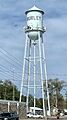
Burley's municipal water tower on 16th Street.
-
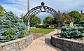
Entrance to Centennial Park, located near the courthouse and City Hall on Overland Avenue.
-
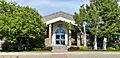
City Hall facade, as seen from Centennial Park.
-
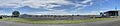
Panoramic view of the Burley Municipal Airport.
-
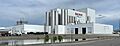
High Desert Milk factory in Burley.
-
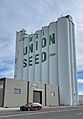
Grain elevator on US Route 30, on the west side of the city.
-
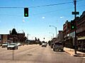
Looking to the south along Overland Avenue (SH 27) in Burley, August 2007


See also
 In Spanish: Burley (Idaho) para niños
