City of Rocks National Reserve facts for kids
Quick facts for kids City of Rocks National Reserve |
|
|---|---|
|
IUCN Category V (Protected Landscape/Seascape)
|
|
 |
|
| Location | Cassia County, Idaho, United States |
| Nearest city | Oakley, Idaho |
| Area | 14,407 acres (58.30 km2) |
| Elevation | 6,260 ft (1,910 m) |
| Designation | United States National Reserve |
| Established | November 18, 1988 |
| Visitors | 130,276 (in 2017) |
| Governing body | National Park Service & Idaho Department of Parks and Recreation |
| Website | City of Rocks National Reserve |
| Designated: | 1974 |
| Designated: | 1964 |
| Reference #: | 66000308 |
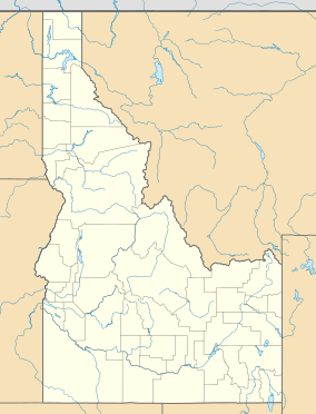
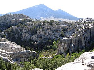
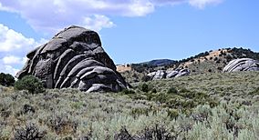
The City of Rocks National Reserve, also known as the Silent City of Rocks, is a special protected area and state park in south-central Idaho. It's about 2 miles (3.2 km) north of the border with Utah. This place is famous for its huge granite rock formations and is a fantastic spot for rock climbing.
The tall rock formations here are made of very old granite. Many climbers simply call this area "The City." It's a popular place for rock climbing, with over 1,000 different routes to try. In the 1980s, some of the hardest climbing routes in the country were found here.
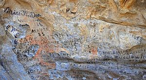
Long ago, in the 1840s and 1850s, groups of pioneers traveling west on the California Trail passed through this area. They would leave the Raft River valley and travel through the City of Rocks. You can still see their names or initials written in wagon axle grease on rocks like Register Rock. You can even see ruts (grooves) from their wagon wheels in some of the rocks!
Contents
Exploring the City of Rocks
In 1849, a group of pioneers camped at the City of Rocks. One traveler in August saw the distant rocks like "water thrown up into the air." Starting in 1843, the City of Rocks became an important landmark for pioneers on the California Trail. It was also used later for freight routes and stagecoach lines.
The area's amazing history, geology, beautiful scenery, and fun activities led to it becoming the City of Rocks National Reserve in 1988. This special park is managed by both the National Park Service and the Idaho Department of Parks and Recreation. They work together to protect it.
Native American History
The Shoshone and Bannock tribes once hunted buffalo in the City of Rocks area. They also gathered nuts from the pinyon pine trees. When horses arrived in the Americas and more European settlers came, it changed the Shoshone-Bannock way of life. They were not happy about the newcomers, but there was little they could do. Most pioneers didn't see Native Americans, but some journals mention smoke rising from the hills.
In 1826, Peter Skene Ogden and his group of beaver trappers were the first Europeans to see the City of Rocks. Since there weren't many beavers, the area was mostly left alone until 1843. That's when many wagons started passing through each summer.
The California Trail
Early explorers and mountain men found a good wagon route to California. This route went up the Raft River, through the City of Rocks, and over Granite Pass. From there, it followed streams to the Humboldt River. Pioneers could then follow the Humboldt River west to the Sierra Nevada mountains and into California.
By 1850, so many people were on the trail that it looked like a long, moving village heading to California. The City of Rocks and nearby Granite Pass were about halfway to California for these pioneers. In 1852, about 52,000 people passed through the City of Rocks on their way to join the California Gold Rush.
After the first transcontinental railroad was finished in 1869, fewer wagons used these long routes. However, wagons and stagecoaches were still used for local supply routes. A stagecoach route connected the railroad station in Kelton, Utah, to Boise, Idaho. This route also passed through the City of Rocks. Pioneers began to settle in the City of Rocks area in the late 1800s.
One favorite camping spot for pioneers was Camp Rock. They wrote their names and dates on the rock using axle grease.
Facts About the Reserve
In 1957, a part of the City of Rocks became a state park. In 1964, a much larger area was named a National Historic Landmark. This means it's a very important historical site. In 1974, it was also named a National Natural Landmark because of its special natural features.
The City of Rocks National Reserve was officially created on November 18, 1988. It covers about 14,407 acres (58.3 km²). The National Park Service and the Idaho Department of Parks and Recreation work together to manage the reserve. This is a unique partnership! More than 80,000 people visit the reserve each year. The main office for the park is in Almo.
Nature and Environment
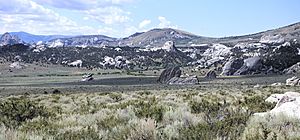
The City of Rocks is a unique place with huge granite rocks rising from the sagebrush landscape. It has always attracted people. The Shoshone tribes camped here, as did the pioneers on the California Trail. The reserve has a lot of different plants and animals living in a small area. The many shapes, colors, and textures of the rocks make the scenery very beautiful.
Rock Formations
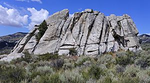
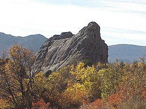
The amazing shapes of the rocks in the City of Rocks were formed over millions of years. Most of the tall rock spires are made of granite that is about 28 million years old. But some spires are made of even older granite, about 2.5 billion years old! These are some of the oldest rocks in the western United States.
The rocks got their interesting shapes through a process called exfoliation. This is when thin layers of rock peel off, like an onion, along cracks in the rocks. These cracks formed as the granite cooled, expanded, and shifted over time. Some of these granite formations are as tall as 600 feet (180 m)! Many of the rocks have flat-bottomed pits on top called panholes. The most famous one is on top of Bath Rock, which often fills with water from rain or snow.
Animals of the Reserve
The City of Rocks is home to many different kinds of animals. This includes mammals, birds, reptiles, and insects.
- Amphibians: You might find frogs and toads near water, like the boreal toad and northern leopard frog.
- Birds: Many birds of prey live here, such as the golden eagle, prairie falcon, and red-tailed hawk. Other common birds include sage grouse, pinyon jay, and mountain bluebird.
- Mammals: Some mammals you might see are cougars, mule deer, coyotes, bobcats, and yellow-bellied marmots.
- Reptiles: Lizards like the western fence lizard and sagebrush lizard are common. Snakes include the western rattlesnake (the only venomous snake here), Great Basin gopher snake, and wandering garter snake.
Plants of the Reserve
The City of Rocks has many interesting plants:
- The Kruckeberg's sword fern grows in cool, damp cracks in the granite. It's usually found at higher elevations. Visitors should be careful not to step on it.
- You'll see many piñon and juniper trees. The piñon nuts are edible and gathered by local people.
- Higher up, you'll find mountain big sagebrush, snowberry, and bitterbrush.
- Groves of aspen and Douglas-fir trees grow on the upper slopes and in canyons with streams.
Other common plants include:
- Forests of piñon and juniper trees.
- Conifer and aspen forests.
- Plants along rivers and streams.
- Big sagebrush and grassy areas.
- Mixed scrubland.
- Mountain mahogany shrubs.
- High elevation meadows.
Weather in the Reserve
The climate here is semi-dry, meaning it doesn't get a lot of rain. Temperatures can change a lot between day and night, and between seasons. Summers are hot and dry, but sometimes there are thunderstorms.
| Climate data for OAKLEY, ID | |||||||||||||
|---|---|---|---|---|---|---|---|---|---|---|---|---|---|
| Month | Jan | Feb | Mar | Apr | May | Jun | Jul | Aug | Sep | Oct | Nov | Dec | Year |
| Record high °F (°C) | 64 (18) |
70 (21) |
77 (25) |
90 (32) |
98 (37) |
104 (40) |
105 (41) |
107 (42) |
100 (38) |
91 (33) |
76 (24) |
73 (23) |
107 (42) |
| Mean daily maximum °F (°C) | 38.1 (3.4) |
42.8 (6.0) |
50.8 (10.4) |
59.9 (15.5) |
68.4 (20.2) |
77.4 (25.2) |
86.6 (30.3) |
85.5 (29.7) |
75.8 (24.3) |
64.3 (17.9) |
49.4 (9.7) |
39.6 (4.2) |
61.5 (16.4) |
| Mean daily minimum °F (°C) | 19.0 (−7.2) |
22.7 (−5.2) |
27.7 (−2.4) |
33.3 (0.7) |
40.0 (4.4) |
46.9 (8.3) |
54.4 (12.4) |
52.9 (11.6) |
44.2 (6.8) |
35.9 (2.2) |
27.3 (−2.6) |
20.5 (−6.4) |
35.4 (1.9) |
| Record low °F (°C) | −25 (−32) |
−27 (−33) |
−2 (−19) |
2 (−17) |
17 (−8) |
24 (−4) |
31 (−1) |
30 (−1) |
17 (−8) |
8 (−13) |
−14 (−26) |
−26 (−32) |
−27 (−33) |
| Average precipitation inches (mm) | 0.80 (20) |
0.68 (17) |
0.91 (23) |
1.19 (30) |
1.52 (39) |
1.18 (30) |
0.71 (18) |
0.72 (18) |
0.75 (19) |
0.86 (22) |
0.78 (20) |
0.76 (19) |
10.86 (275) |
| Average snowfall inches (cm) | 7.0 (18) |
4.5 (11) |
4.2 (11) |
2.1 (5.3) |
0.5 (1.3) |
0 (0) |
0 (0) |
0 (0) |
0 (0) |
0.5 (1.3) |
2.9 (7.4) |
5.5 (14) |
27.2 (69.3) |
| Source: http://www.wrcc.dri.edu/cgi-bin/cliMAIN.pl?id6542 | |||||||||||||
Mountains and Land
The reserve is in the southern part of the Albion Mountains. It's bordered by the Raft River valley to the east and the Snake River valley to the north. The elevation ranges from about 5,650 feet (1,720 m) to 8,867 feet (2,703 m) at the top of Graham Peak.
Soils
Most of the soil in the reserve is made of a coarse, sandy material called grus. This comes from the granite rocks breaking down. This soil can easily be washed away by water, especially near roads and on steep slopes.
Images for kids
 | Sharif Bey |
 | Hale Woodruff |
 | Richmond Barthé |
 | Purvis Young |


