Raft River facts for kids
Quick facts for kids Raft River |
|
|---|---|

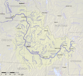
Map of the Snake River watershed, USA
|
|
| Country | United States |
| State | Idaho / Utah |
| Physical characteristics | |
| Main source | Albion Mountains Cassia County, Idaho and Box Elder County, Utah |
| River mouth | Snake River Cassia County, Idaho 42°36′20″N 113°14′26″W / 42.60556°N 113.24056°W |
The Raft River is a river about 108-mile-long (174 km) in the western United States. It flows through northern Utah and southern Idaho. This river is a tributary of the larger Snake River. It is also part of the huge Columbia River Basin.
Contents
Where Does the Raft River Flow?
The Raft River starts high up in the mountains. Its main sources are on the east side of the Albion Mountains. These mountains are southeast of a town called Oakley, Idaho.
One important stream that feeds the Raft River is Clear Creek. This creek collects water from the north side of the Raft River Mountains in Utah. Water from the nearby Grouse Creek Range also flows into the Raft River. Parts of the Black Pine and Sublett mountains also contribute water. The river generally flows north. It joins the Snake River in Cassia County, Idaho.
Understanding the Raft River's Watershed
A river's drainage basin (or watershed) is the area of land where all the water drains into that river. The Raft River's watershed is quite large. It covers about 1,506 square miles (3,901 km2) of land. Most of this area, about 95%, is located in Idaho.
This watershed includes four different parts of the Sawtooth National Forest. This means the river helps support the plants and animals in these forest areas.
A River with a Story: The Raft River's History
The Raft River got its name from early pioneers. These brave travelers were on the Oregon Trail. They often had to cross the river using rafts. This was especially true when the river was high. Sometimes, beaver dams would make the river flood, making it even harder to cross.
The Oregon Trail crossed the Raft River about 2 miles (3 km) south of Interstate 86. A very important spot called the "Parting of the Ways" was at the top of a bluff above the river. Here, the Oregon Trail continued west. Another famous trail, the California Trail, turned south.
This area along the river holds many stories of the pioneers. Graves of some who faced great challenges on their journey can be found here. The Raft River was a significant landmark for these early travelers. It marked a place where their paths often separated, leading them to different parts of the American West.
See also

- In Spanish: Río Raft para niños
 | Calvin Brent |
 | Walter T. Bailey |
 | Martha Cassell Thompson |
 | Alberta Jeannette Cassell |

