Black Pine Mountains facts for kids
Quick facts for kids Black Pine Mountains |
|
|---|---|

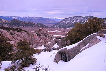
The snowcapped Black Pine Mountains in far background viewed from the City of Rocks National Reserve
|
|
| Highest point | |
| Peak | Black Pine Mountains High Point |
| Elevation | 9,389 ft (2,862 m) |
| Dimensions | |
| Length | 53 mi (85 km) N/S |
| Width | 24 mi (39 km) E/W |
| Area | 577 sq mi (1,490 km2) |
| Geography | |
| Country | United States |
| State | Idaho |
The Black Pine Mountains are a group of mountains found mostly in Idaho (about 65%) and partly in Utah (about 35%). They stretch across Cassia County in Idaho and into Box Elder County in Utah.
The tallest spot in these mountains is called Black Pine Mountains High Point, also sometimes known as Black Peak. It stands about 9,395 feet (2,864 meters) high! These mountains are part of a larger area called the Basin and Range Province. They also play a role in the Great Basin Divide, which separates where water flows. In Idaho, these mountains are part of the Sawtooth National Forest.
Where Are the Black Pine Mountains?
The Black Pine Mountains are surrounded by other mountain ranges. The Raft River Mountains are to the southwest. The Albion Mountains are to the west, and the Sublett Mountains are to the northeast.
Water from the northern parts of these mountains flows into the Snake River. This river is a branch of the big Columbia River. Water from the southern parts drains into the Great Salt Lake. The town of Snowville, Utah is southeast of the mountains. Malta, Idaho is to the northwest. A major highway, Interstate 84, passes just east of the mountains.
Tallest Spots in the Black Pine Mountains
Here are some of the highest points, or peaks, in the Black Pine Mountains. Each peak has its own height and location.
| Mountain Peak | Elevation | Prominence | Isolation | Location |
|---|---|---|---|---|
| Black Pine Mountains High Point | 9,389 ft 2862 m |
4,069 ft 1240 m |
21.1 mi 33.9 km |
42°08′19″N 113°07′32″W / 42.13866°N 113.125608°W |
| Black Pine Peak | 9,386 ft 2861 m |
186 ft 57 m |
1.30 mi 2.09 km |
42°07′13″N 113°07′13″W / 42.120274°N 113.12037°W |
| Peak 8,376 | 8,376 ft 2553 m |
396 ft 121 m |
1.70 mi 2.74 km |
42°06′50″N 113°05′19″W / 42.1139°N 113.0885°W |
| Gunnell Benchmark | 8,300 ft 2530 m |
1,160 ft 354 m |
2.93 mi 4.72 km |
42°04′42″N 113°07′38″W / 42.0782°N 113.1272°W |
| Black Pine Cone | 8,020 ft 2445 m |
800 ft 244 m |
2.66 mi 4.28 km |
42°04′55″N 113°03′35″W / 42.0819°N 113.0597°W |
| Peak 7,734 | 7,734 ft 2357 m |
564 ft 172 m |
4.75 mi 7.64 km |
42°11′12″N 113°08′38″W / 42.1867°N 113.1440°W |
| Peak 7,620 | 7,620 ft 2323 m |
400 ft 122 m |
1.29 mi 2.07 km |
42°05′49″N 113°04′28″W / 42.0970°N 113.0744°W |
| Peak 7,144 | 7,144 ft 2177 m |
404 ft 123 m |
2.68 mi 4.31 km |
42°09′08″N 113°04′52″W / 42.1523°N 113.0812°W |
 | Delilah Pierce |
 | Gordon Parks |
 | Augusta Savage |
 | Charles Ethan Porter |

