Columbia River drainage basin facts for kids
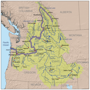
The Columbia River drainage basin is a huge area of land where all the water flows into the Columbia River. This mighty river is in the Pacific Northwest part of North America. The entire basin covers about 668,000 square kilometers (258,000 square miles). Sometimes, when people say "Columbia Basin," they are talking about a smaller area. This usually means the part of the basin found in eastern Washington.
Contents
What is the Columbia River Basin?
The Columbia Basin includes a large part of the Canadian province of British Columbia. It also covers most of the U.S. states of Idaho, Oregon, and Washington. Smaller parts are in Montana, Nevada, Utah, and Wyoming.
Where Does the Water Flow?
The edges of the basin show where water flows into the Columbia River. To the south and southeast, it borders the Great Basin. To the northeast, it meets the basins of the Saskatchewan River and the Mackenzie River. To the northwest, it borders the Fraser River basin. The Columbia Basin stretches from the Rocky Mountains in the east. It goes through the Cascade Range all the way to the Pacific Ocean in the west.
The Mighty Columbia River
The Columbia River pours more water into the Pacific Ocean than any other river in North or South America. It travels about 2,040 kilometers (1,270 miles) to the Pacific Ocean. Along its journey, it flows through four mountain ranges. These are the Rockies, Selkirks, Cascades, and coastal mountains. The river drains a total area of about 668,000 square kilometers (258,000 square miles).
River's Source and Tributaries
The main part of the Columbia River starts at Columbia Lake in Canada. This lake is on the western side of the Rocky Mountain Range. The river's biggest branch is the Snake River. The Snake River flows for about 1,670 kilometers (1,038 miles). It starts in Yellowstone National Park in Wyoming before joining the Columbia.
Fish and Exploration
When Lewis and Clark explored this area in the early 1800s, they saw huge numbers of fish. Many salmon would return to the rivers to lay their eggs every year. Clark wrote in 1805 that "The multitudes of this fish are almost inconceivable." Back then, the Columbia and its branches offered about 20,800 kilometers (12,935 miles) of clean river homes for fish.
How People Talk About the Columbia Basin
People who live near where the Columbia River and Snake River meet often use the term "Columbia Basin" differently. They use it to mean their own, much smaller area. This region is centered around the Tri-Cities, Washington area.
Farmland and Irrigation
This local use of "Columbia Basin" is similar to the Columbia Plateau. It generally means the open, treeless area surrounded by mountains. These mountains include the Cascades, Blue, Wallowa, and Rocky ranges. It also includes the Okanagan Highland. This idea of the Columbia Basin has grown over time. It first focused on land watered by the Grand Coulee Dam and the Columbia Basin Project. Now, it includes other areas that use irrigation, like the Yakima and Walla Walla valleys. This region has very good farmland with rich soil.
 | Mary Eliza Mahoney |
 | Susie King Taylor |
 | Ida Gray |
 | Eliza Ann Grier |


