
Wallowa Mountains facts for kids
Quick facts for kids Wallowa Mountains |
|
|---|---|

The Wallowas from Mount Howard. Hurwal Divide is in the front and center, and Sacajawea Peak is behind and to the left. Matterhorn is on the far right.
|
|
| Highest point | |
| Peak | Sacajawea Peak (Eagle Cap Wilderness, Wallowa County) |
| Elevation | 9,838 ft (2,999 m) |
| Dimensions | |
| Length | 40 mi (64 km) NW–SE |
| Geography | |
| Country | United States |
| State | Oregon |
| Counties | Wallowa Union |
| Range coordinates | 45°12′00″N 117°19′04″W / 45.20000°N 117.31778°W |
The Wallowa Mountains are a cool mountain range in northeastern Oregon, United States. They stretch about 40 miles (64 km) from northwest to southeast. You can find them between the Blue Mountains and the Snake River.
Some people think they are part of the Blue Mountains. They are also called the "Alps of Oregon" because they look so grand! A big part of the Wallowas is protected as the Eagle Cap Wilderness. This area is part of the Wallowa–Whitman National Forest.
Contents
Exploring the Wallowa Mountains
The Wallowa Mountains have several rivers flowing from them. The Wallowa River starts on the north side of the mountains. The Minam River is a smaller river that flows through the west side. The Imnaha River flows from the east side of the range.
The tallest point in these mountains is Sacajawea Peak. It stands 9,838 feet (2,999 meters) above sea level. Sacajawea Peak is the sixth highest mountain in all of Oregon. It is also the tallest peak in Oregon outside of the Cascade Range.
How the Mountains Were Formed
Scientists believe the Wallowa Mountains are a piece of land that moved here long ago. The center of the Wallowas is made of a type of rock called granite. This granite formed from hot, melted rock (magma) deep underground. This happened between 160 million and 120 million years ago.
When this hot rock pushed up, it lifted the land above it. Back then, this area was a tropical sea. You can still see evidence of this in the mountains. There are rocks like slate, quartzite, and marble. These rocks formed from old ocean sediments.
Glaciers and Valleys
Long ago, during the last Ice Age, huge glaciers moved through the Wallowas. These glaciers carved out the deep valleys you see today. As the glaciers melted, they left behind piles of rock and dirt called moraines. You can see many of these moraines in the valleys.
The melting ice also created a lot of water. This water carried sediment, like sand and gravel, to the bottom of the valleys. This created flat areas where rivers now flow.
Weather in the Mountains
The Wallowa Mountains get a lot of snow. The most snow usually falls around March. The mountains get more rain and snow than the areas around them. This is because the mountains force moist air to rise and cool.
Near the top of the mountains, over 100 inches (254 cm) of precipitation can fall each year. In the valleys, it can be as low as 10 inches (25 cm).
Avalanche Safety
The Wallowa Mountains are a popular spot for winter sports. People enjoy backcountry skiing and snowmobiling here. However, avalanches are a serious danger in the mountains. An avalanche is a large slide of snow down a mountainside. It is very important to be careful and know the risks if you go into the backcountry in winter.
Plants and Animals
The Wallowa Mountains have a special environment because they get so much rain and snow. This creates a wet habitat where many different plants grow. You can find plants here that are also found in the Rocky Mountains and the Cascades.
At lower elevations, you will often see Douglas fir trees on slopes. In the valley bottoms, you might find Engelmann spruce and lodgepole pine. Below 5,300 feet (1,615 meters), grand fir trees are common. Near springs and wet areas, you can see willows and sedge plants.
Higher up, above 7,000 feet (2,134 meters), subalpine fir trees are most common. On ridges and sunny slopes, you might spot whitebark pine trees.
People of the Wallowas
The Wallowa Mountains were originally home to the Wallowa band of the Nez Perce people. They lived in the canyons and used controlled fires to create meadows for their horses. The Nez Perce got horses around the year 1730.
In 1834, Captain Benjamin Bonneville traveled through these mountains. He met with the Nez Perce on his way to Fort Walla Walla. In the 1840s, more settlers began to move west. The Nez Perce started trading with these new arrivals.
Changes to the Land
A settlement was built in the mountains in 1861. In 1863, a new treaty was signed. This treaty gave land that was promised to the Nez Perce in an earlier treaty to the American government. The settlers in the mountains then moved to what is now La Grande, Oregon.
The Wallowa Valley, which was home to Chief Joseph and his people, was opened to settlers in 1867. Surveyors began mapping the land until 1869. In 1873, the Wallowa Valley was divided. One half was for the Nez Perce, and the other half was for settlers.
Just two years later, in 1875, the government told the Nez Perce they could no longer live in the valley. The first road into the valley, a toll road, was built that same year. In 1877, the U.S. Government tried to force the Nez Perce to leave. This made the Nez Perce angry, and they raided the settlers. This led to the Nez Perce War.
Modern Developments
Logging (cutting down trees for wood) began in the late 1880s. Logs were transported using streams and rivers. A dam was built on Wallowa Lake in 1884 to help water the valley.
In 1908, the first railroad line reached the valley. More rail lines were built by the Union Pacific Railroad in 1919. These lines made it safer to transport logs. The dam at Wallowa Lake was replaced with a concrete dam in 1916, and a new one was finished in 1929.
Images for kids
-
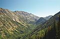
The valley of the Lostine River in the mountains

