
Imnaha River facts for kids
Quick facts for kids Imnaha River |
|
|---|---|

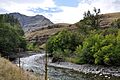
Imnaha River near Imnaha
|
|

Location of the mouth of the Imnaha River in Oregon
|
|
| Country | United States |
| State | Oregon |
| County | Wallowa |
| Physical characteristics | |
| Main source | Confluence of the North and South forks of the Imnaha River Wallowa–Whitman National Forest, Wallowa County, Oregon 5,324 ft (1,623 m) 45°06′47″N 117°07′31″W / 45.11306°N 117.12528°W |
| River mouth | Snake River Hells Canyon National Recreation Area, Wallowa County, Oregon 945 ft (288 m) 45°49′03″N 116°45′53″W / 45.81750°N 116.76472°W |
| Length | 73 mi (117 km) |
| Basin features | |
| Basin size | 855 sq mi (2,210 km2) |
| Type: | Wild, Scenic, Recreational |
| Designated: | October 28, 1988 |
The Imnaha River is a river in Oregon, United States. It flows for about 73.3-mile-long (118.0 km) before joining the Snake River. The river flows mostly north through Wallowa County, Oregon. It is special because its entire length is part of the Wild and Scenic Rivers System. This means it is protected for its natural beauty and importance.
The Imnaha River follows a natural crack in the Earth called a geologic fault. This fault leads it all the way to the Snake River. The land around the Imnaha River includes parts of the Wallowa–Whitman National Forest. It also passes through special protected areas like the Eagle Cap Wilderness and Hells Canyon National Recreation Area. The only town along the river is Imnaha. The Imnaha River joins the Snake River about 4 miles (6 km) from where the Snake River meets the Salmon River in Idaho.
Journey of the Imnaha River
The Imnaha River starts where its north and south forks meet. This beginning is found in the beautiful Eagle Cap Wilderness and the Wallowa–Whitman National Forest. From there, the river first flows east, then turns north. It continues flowing north or slightly northeast for about 64 miles (103 km). Finally, it reaches the Snake River right on the border between Oregon and Idaho.
The river begins at a high elevation, about 5,300 feet (1,600 m) above sea level. As it travels through a deep canyon, it drops about 4,400 feet (1,300 m) by the time it reaches the Snake River. This big drop creates many exciting rapids and features along its path.
River Features and Landmarks
As the Imnaha River flows east from its start, it passes over Imnaha Falls. This is a beautiful waterfall along its course. Soon after, the river enters the Hells Canyon National Recreation Area. This area is known for its deep canyons and stunning views.
Further downstream, the river leaves the Eagle Cap Wilderness. It then flows past several campgrounds, like Indian Crossing and Evergreen. These spots are great for people who want to enjoy nature. A road called Upper Imnaha Road (also known as NFD 3960) runs alongside the river for a long stretch.

As the river turns north, it continues its journey. Many smaller creeks join the Imnaha River along the way, adding to its flow. The river also passes under the Hells Canyon Scenic Byway. This scenic road offers amazing views of the surrounding mountains and canyons.
Near the Imnaha River Acclimation Site and Weir, scientists work to help Chinook salmon. They collect adult salmon here and release young salmon (called smolts) to help their populations grow. This is part of a program to keep the river healthy for fish.
The Final Stretch
As the Imnaha River continues its journey, Upper Imnaha Road crosses the river a few times. This road helps people access different parts of the river. The river flows past Park Cemetery and other small landmarks. Many more creeks, like Musty Creek and Line Creek, join the Imnaha River as it gets closer to its end.
The river also flows by the Imnaha Grange Hall. This is a community building in the area. Further downstream, the river passes the historic College Creek Ranger Station. This station is listed on the National Register of Historic Places.
Near the town of Imnaha, the river flows under Oregon Route 350. This highway connects the community to Joseph. After passing Imnaha, the road alongside the river becomes Lower Imnaha Road. The United States Geological Survey (USGS) has a special station here to measure the river's flow.
Finally, the Imnaha River has no road next to it for its last part. It flows through a wilder area before joining the mighty Snake River. This meeting point is about 4.0 miles (6.4 km) upstream from where the Snake River meets the Salmon River in Idaho. The Imnaha River's journey ends here, as its waters become part of the larger Snake River system.
Images for kids
-
Imnaha River near Imnaha
