
Salmon River (Idaho) facts for kids
Quick facts for kids Salmon River |
|
|---|---|

Salmon River in Sawtooth NRA
|
|

Map of the Salmon River, showing its Middle Fork tributary and connection to the Columbia River via the Snake River
|
|
| Country | United States |
| State | Idaho |
| Cities | Salmon, Challis |
| Physical characteristics | |
| Main source | Sawtooth Range near Norton Peak, Blaine County 9,220 ft (2,810 m) 43°47′48″N 114°46′36″W / 43.79667°N 114.77667°W |
| River mouth | Snake River west of White Bird, Idaho and Nez Perce Counties 919 ft (280 m) 45°51′23″N 116°47′37″W / 45.85639°N 116.79361°W |
| Length | 425 mi (684 km) |
| Basin features | |
| Basin size | 14,000 sq mi (36,000 km2) |
| Tributaries |
|
| Type: | Wild, Recreational |
| Designated: | July 23, 1980 |

The Salmon River is a famous river in Idaho, located in the western part of the United States. It is also known as "The River of No Return." This river flows for about 425 miles (684 km) through the middle of Idaho. It drains a large, wild area of 14,000 square miles (36,000 km²).
The Salmon River starts high in the mountains and drops over 7,000 feet (2,100 m) by the time it reaches the Snake River. It is one of the biggest rivers in the United States that does not have any dams on its main part. Towns along the river include Stanley, Challis, and Salmon.
The lower half of the Salmon River forms a special boundary. It separates the Pacific time in northern Idaho from the Mountain time in the rest of the state.
Contents
Where Does the Salmon River Flow?
The Salmon River begins in the Sawtooth Mountains at over 9,200 feet (2,800 m) high. For its first 30 miles (48 km), it flows north through the Sawtooth Valley. Then, it turns east near Stanley. Along its journey, it picks up water from other rivers like the Yankee Fork and the East Fork.
North of the town of Salmon, the river turns west. It then flows through more than 200 miles (320 km) of deep canyons. These canyons are some of the deepest in the United States, even deeper than the Grand Canyon. Only Hells Canyon on the Snake River is deeper. Here, the river is joined by its two largest branches: the Middle Fork and the South Fork.
About 10 miles (16 km) after the Middle Fork joins, the Salmon River creates the time zone boundary for Idaho. South of the river is Mountain Time, and north is Pacific Time. The river then turns sharply north at Riggins. It flows north until it meets the Snake River. The Salmon River is the longest river that stays entirely within one U.S. state.
A Look Back in Time: Salmon River History
Who Lived by the River?
People have lived along the Salmon River for at least 8,000 years. Many Native American tribes, including the Nez Perce, called this area home. They thought the river was very important and sacred. It provided lots of food, especially the many salmon species.
Early Explorers and Mountain Men

In 1805, the famous Lewis and Clark explored the Salmon River. They found it too wild and rough to travel by boat. One of them, Clark, even named it "Louis's river." But the name "Salmon River" stuck by 1810.
Later, in the early to mid-1900s, other explorers came and stayed. One of the most famous was Sylvan Ambrose Hart, also known as Buckskin Bill. He was one of the last "Mountain Men" to live in the Salmon River Canyon. He arrived around 1928 and lived there for nearly 50 years. Buckskin Bill made many of his own tools and items, like knives and rifles. His cabin is now a museum.
The Gold Rush Era
In the 1860s, people found gold along the Salmon River. This started a "gold rush," and many miners came to the area. This led to conflicts with the Nez Perce people, as the miners were on their ancestral lands. You can still see signs of old mines along the river today.
Fun on the Salmon River

The Salmon River area offers many ways to have fun outdoors. Parts of the river, like the Middle Fork and a section of the main river, are protected as National Wild and Scenic Rivers. This means they are kept wild and natural for everyone to enjoy. The Middle Fork is often called the "crown jewel" of this system.
The Salmon River is a very popular spot for whitewater kayaking, canoeing, and rafting. The deep canyons offer amazing views of the region's unique geology. The Frank Church-River of No Return Wilderness Area has one of the deepest canyons in the U.S., about 7,000 feet (2,100 m) deep.
Many outdoor lodges are found along the river. You can reach them by boat, raft, hiking, or even small airplanes. The Middle Fork and Main Fork sections of the river are popular for rafting trips. The Middle Fork is also known as one of the best places in the country for catch and release fly fishing. Other fun activities include camping, hiking, and mountain biking.
Wildlife in the Salmon River
The Salmon River is very important for fish. Historically, it produced a large percentage of the steelhead (ocean-going rainbow trout) and chinook salmon in the entire Columbia River Basin. In fact, most of the remaining salmon and steelhead homes in the Columbia River Basin are in the Salmon River area.
Even though there is great habitat, salmon and steelhead numbers have not fully recovered. This is partly because of four large dams on the lower Snake River. Young salmon and returning adult salmon must pass these dams. Many people want these dams removed to help the fish survive. This issue is still being discussed today.
Monitoring the River: USGS Stations
The United States Geological Survey (USGS) has special stations that measure the water level of the Salmon River and its smaller streams. This helps scientists understand the river better. You can find real-time data from these stations on the USGS website.
| Stream | Location | Site number | Coordinates | Drainage area | Avg discharge | Max discharge | Min discharge | Website |
|---|---|---|---|---|---|---|---|---|
| Salmon River | Clayton, ID | 13296500 | 44°16′06″N 114°43′58″W / 44.26833°N 114.73278°W | 807 sq mi (2,090 km2) | 974 cu ft/s (27.6 m3/s) | 10,400 cu ft/s (290 m3/s) | 160 cu ft/s (4.5 m3/s) | [1] |
| Salmon River | Salmon, ID | 13302500 | 45°11′01″N 113°53′43″W / 45.18361°N 113.89528°W | 3,737 sq mi (9,680 km2) | 1,923 cu ft/s (54.5 m3/s) | 17,700 cu ft/s (500 m3/s) | 242 cu ft/s (6.9 m3/s) | [2] |
| Salmon River | Shoup, ID | 13307000 | 45°19′21″N 114°26′24″W / 45.32250°N 114.44000°W | 6,239 sq mi (16,160 km2) | 2,913 cu ft/s (82.5 m3/s) | 25,700 cu ft/s (730 m3/s) | 600 cu ft/s (17 m3/s) | [3] |
| Salmon River | White Bird, ID | 13317000 | 45°45′01″N 116°19′26″W / 45.75028°N 116.32389°W | 13,421 sq mi (34,760 km2) | 11,090 cu ft/s (314 m3/s) | 130,000 cu ft/s (3,700 m3/s) | 1,000 cu ft/s (28 m3/s) | [4] |
| Valley Creek | Stanley, ID | 13295000 | 44°13′21″N 114°55′52″W / 44.22250°N 114.93111°W | 147 sq mi (380 km2) | 198 cu ft/s (5.6 m3/s) | 2,210 cu ft/s (63 m3/s) | 34 cu ft/s (0.96 m3/s) | [5] |
| Yankee Fork Salmon River | Clayton, ID | 13296000 | 44°16′44″N 114°44′02″W / 44.27889°N 114.73389°W | 189 sq mi (490 km2) | 198 cu ft/s (5.6 m3/s) | 3,360 cu ft/s (95 m3/s) | 10 cu ft/s (0.28 m3/s) | [6] |
| Thompson Creek | Clayton, ID | 13297330 | 44°16′13″N 114°31′00″W / 44.27028°N 114.51667°W | 29.1 sq mi (75 km2) | 16.8 cu ft/s (0.48 m3/s) | 442 cu ft/s (12.5 m3/s) | 1.0 cu ft/s (0.028 m3/s) | [7] |
| Squaw Creek | Clayton, ID | 13297355 | 44°17′27″N 114°28′18″W / 44.29083°N 114.47167°W | 71.6 sq mi (185 km2) | 33.2 cu ft/s (0.94 m3/s) | 755 cu ft/s (21.4 m3/s) | 3.3 cu ft/s (0.093 m3/s) | [8] |
| Pahsimeroi River | Ellis, ID | 13302005 | 44°41′30″N 114°02′49″W / 44.69167°N 114.04694°W | 830 sq mi (2,100 km2) | 230 cu ft/s (6.5 m3/s) | 710 cu ft/s (20 m3/s) | 87 cu ft/s (2.5 m3/s) | [9] |
| Lemhi River | Lemhi, ID | 13305000 | 44°56′24″N 113°38′21″W / 44.94000°N 113.63917°W | 897 sq mi (2,320 km2) | 257 cu ft/s (7.3 m3/s) | 2,430 cu ft/s (69 m3/s) | 22 cu ft/s (0.62 m3/s) | [10] |
| Lemhi River | Salmon, ID | 13305310 | 45°07′58″N 113°47′56″W / 45.13278°N 113.79889°W | 1,216 sq mi (3,150 km2) | 258 cu ft/s (7.3 m3/s) | 2,920 cu ft/s (83 m3/s) | 0.75 cu ft/s (0.021 m3/s) | [11] |
| Blackbird Creek | Cobalt, ID | 13306336 | 45°05′29″N 114°17′53″W / 45.09139°N 114.29806°W | Unknown | 6.8 cu ft/s (0.19 m3/s) | 100 cu ft/s (2.8 m3/s) | 2 cu ft/s (0.057 m3/s) | [12] |
| Panther Creek | Cobalt, ID | 13306370 | 45°05′23″N 114°14′12″W / 45.08972°N 114.23667°W | Unknown | 57.6 cu ft/s (1.63 m3/s) | 1,100 cu ft/s (31 m3/s) | 3.5 cu ft/s (0.099 m3/s) | [13] |
| Napias Creek | Leesburg, ID | 13306385 | 45°12′20″N 114°08′02″W / 45.20556°N 114.13389°W | 41.1 sq mi (106 km2) | 29.2 cu ft/s (0.83 m3/s) | 1,020 cu ft/s (29 m3/s) | 3.5 cu ft/s (0.099 m3/s) | [14] |
| Middle Fork Salmon River | Yellow Pine, ID | 13309220 | 44°43′18″N 115°00′59″W / 44.72167°N 115.01639°W | 1,042 sq mi (2,700 km2) | 1,413 cu ft/s (40.0 m3/s) | 20,900 cu ft/s (590 m3/s) | 190 cu ft/s (5.4 m3/s) | [15] |
| Middle Fork Salmon River | Shoup, ID | 13310199 | 45°17′37″N 114°35′47″W / 45.29361°N 114.59639°W | 2,876 sq mi (7,450 km2) | 2,818 cu ft/s (79.8 m3/s) | 28,600 cu ft/s (810 m3/s) | 349 cu ft/s (9.9 m3/s) | [16] |
| South Fork Salmon River | Krassel Ranger Station | 13310700 | 44°59′13″N 115°43′30″W / 44.98694°N 115.72500°W | 330 sq mi (850 km2) | 535 cu ft/s (15.1 m3/s) | 9,710 cu ft/s (275 m3/s) | 38 cu ft/s (1.1 m3/s) | [17] |
| East Fork South Fork Salmon River | Stibnite, ID | 13311000 | 44°54′21″N 115°19′42″W / 44.90583°N 115.32833°W | 19.3 sq mi (50 km2) | 25.6 cu ft/s (0.72 m3/s) | 394 cu ft/s (11.2 m3/s) | 2.0 cu ft/s (0.057 m3/s) | [18] |
| Sugar Creek | Stibnite, ID | 13311450 | 44°56′10.9″N 115°20′14.0″W / 44.936361°N 115.337222°W | Unknown | 22.9 cu ft/s (0.65 m3/s) | 185 cu ft/s (5.2 m3/s) | 5.5 cu ft/s (0.16 m3/s) | [19] |
| Johnson Creek | Yellow Pine, ID | 13313000 | 44°57′42″N 115°30′00″W / 44.96167°N 115.50000°W | 218 sq mi (560 km2) | 344 cu ft/s (9.7 m3/s) | 6,250 cu ft/s (177 m3/s) | 21 cu ft/s (0.59 m3/s) | [20] |
| Little Salmon River | Riggins, ID | 13316500 | 45°24′47″N 116°19′31″W / 45.41306°N 116.32528°W | 576 sq mi (1,490 km2) | 776 cu ft/s (22.0 m3/s) | 12,600 cu ft/s (360 m3/s) | 54 cu ft/s (1.5 m3/s) | [21] |
Images for kids
-
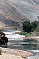
Salmon River, north of Riggins
-
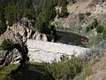
Breached Sunbeam Dam on the Salmon
-
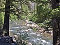
Yankee Fork of the Salmon
-
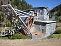
Yankee Fork Gold Dredge
-
Salmon River Canyon 1945


See also
 In Spanish: Río Salmón para niños
