South Fork Salmon River facts for kids
Quick facts for kids South Fork Salmon River |
|
|---|---|

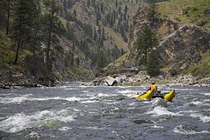
Rafters on the South Fork Salmon River
|
|

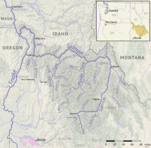
Map showing the Salmon River basin. The South Fork is the second major tributary from left.
|
|
| Country | United States |
| State | Idaho |
| Physical characteristics | |
| Main source | near Monumental Peak Salmon River Mountains, Valley County 7,600 ft (2,300 m) 44°28′47″N 115°41′06″W / 44.47972°N 115.68500°W |
| River mouth | Salmon River near Mackay Bar, Idaho County 2,146 ft (654 m) 45°22′40″N 115°30′47″W / 45.37778°N 115.51306°W |
| Length | 86 mi (138 km) |
| Basin features | |
| Basin size | 1,309 sq mi (3,390 km2) |
| Tributaries |
|
The South Fork Salmon River is a long river in central Idaho, about 86 miles (138 km) long. It flows into the Salmon River. This river runs through a wild, natural area in the Salmon River Mountains. It is the second biggest river that flows into the Salmon River. The Middle Fork is the largest.
Contents
Where is the South Fork Salmon River?
The South Fork Salmon River starts high up in the mountains. It begins near Monumental Peak, which is about 7,902 feet (2,408 meters) tall. This area is part of the Boise National Forest.
The river then flows mostly north. It joins the main Salmon River near a place called Mackay Bar. This meeting point is about 135 miles (217 km) upstream from where the Salmon River meets the Snake River.
River's Path and Size
About halfway along its path, two other important rivers join the South Fork. The East Fork South Fork Salmon River comes in from the east. The Secesh River joins from the west.
The South Fork Salmon River and its smaller streams collect water from a huge area. This area covers about 1,309 square miles (3,390 square kilometers). The land here ranges from very high mountains to lower river valleys. The highest point is North Loon Mountain, at 9,322 feet (2,841 meters). The lowest point is where the river meets the Salmon River, at 2,146 feet (654 meters).
A Look at the River's Past
Long ago, Native American groups lived along the South Fork Salmon River. These groups included the Nez Perce, Shoshone, Bannock, and Paiute. They used the river and its valley for fishing, hunting, and gathering food. Local hot springs were also good places for them to camp during the cold winter months.
Early Explorers and Gold
The first Europeans to see the South Fork might have been a group of fur traders in 1831. They were exploring the western part of the Salmon River area, looking for places with many beavers.
In the 1860s, people looking for gold found it in the South Fork area. This discovery led to the first settlements by Westerners. After the gold rush ended, some miners stayed. They became homesteaders and ranchers, building homes and raising animals.
Logging in the Valley
From the 1940s to the mid-1960s, a lot of trees were cut down in the river's valley. About 320 million board feet of timber was taken from the area. To do this, more than 800 miles (1,287 km) of logging roads were built across the land.
Animals and Plants of the River
The South Fork Salmon River is a very important home for many types of fish. These include Chinook salmon, Westslope cutthroat trout, bull trout, and steelhead trout. Because of this, the river has been named a "critical habitat" for salmon. This means it's a super important place for them to live and grow.
Protecting the River's Health
Even though the river's fish habitat is mostly good, some smaller streams have been hurt. This damage came from logging, mining, and building roads. These activities caused more dirt and mud to wash into the river, which is called "sediment load." This can make the water cloudy and harm fish.
To help fix this, the U.S. Forest Service has been working to restore the area. They have closed about 340 miles (547 km) of old backcountry roads. These roads are now being returned to their natural state.
Wildlife and Forests
The plants in the South Fork area change depending on how high up you go. At lower elevations, you can find grasslands and shrubs. There are also forests with Ponderosa pine, Douglas fir, and Grand fir trees. Higher up, you'll see subalpine fir, lodgepole pine, whitebark pine, and aspen trees.
Many large animals live in this watershed. You might see Rocky Mountain elk, white-tailed deer, and mule deer. There are also black bear, cougar, mountain goat, bighorn sheep, and gray wolf. More than 200 different kinds of birds, both those that live there all year and those that migrate, have been seen in the area.
How the River Flows
The United States Geological Survey (USGS) is a group that studies the Earth. They had a special measuring station, called a stream gage, at the mouth of the South Fork. This station collected data between 1993 and 2003. It showed that the river's average flow was about 1,983 cubic feet per second (56.1 cubic meters per second) each year.
The highest average flow for a year was in 1997, at 3,125 cubic feet per second (88.5 cubic meters per second). The lowest was in 2001, at 869.9 cubic feet per second (24.6 cubic meters per second). The graph below shows how much water flows in the South Fork each month.
Monthly discharges at Mackay Bar (cfs)

Fun Things to Do on the River
The South Fork is known for its exciting whitewater rapids. While not as many people raft here as on the Middle Fork, it's still a popular spot for adventurers. Boaters often start their trips on the Secesh River. This is about 37 miles (60 km) upstream from where the South Fork joins the main Salmon River.
Because the South Fork and its tributary, the Secesh, are so natural and untouched, they are being considered for a special protection. They might become part of the National Wild and Scenic Rivers system. This would help keep them wild and beautiful for future generations.
 | Jessica Watkins |
 | Robert Henry Lawrence Jr. |
 | Mae Jemison |
 | Sian Proctor |
 | Guion Bluford |

