Middle Fork Salmon River facts for kids
Quick facts for kids Middle Fork Salmon River |
|
|---|---|

Middle Fork Salmon River
|
|

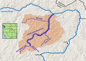
Map of the Middle Fork Salmon River, its watershed boundary, and main tributaries.
|
|
|
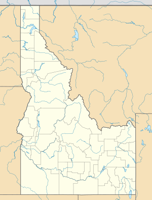
Location of the mouth of the Middle Fork of the Salmon River in Idaho
|
|
| Country | United States |
| State | Idaho |
| Physical characteristics | |
| Main source | 44°26′57″N 115°13′51″W / 44.44917°N 115.23083°W |
| River mouth | Salmon River 3,015 ft (919 m) 45°17′50″N 114°35′36″W / 45.29722°N 114.59333°W |
| Type: | Wild, Scenic |
| Designated: | October 2, 1968 |
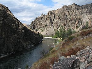
The Middle Fork of the Salmon River is a wild and beautiful river in central Idaho, in the northwestern United States. It stretches for about 104 miles (167 km). This river flows into the Salmon River. It is located right in the middle of the huge Frank Church-River of No Return Wilderness Area. This wilderness area is one of the largest places without roads in the lower 48 states.
The Middle Fork is super popular for whitewater rafting and kayaking. It's known for being a challenging and exciting adventure. In 1980, the area around the river was given special protection by the government. This helps keep it wild and natural for everyone to enjoy.
Contents
Journey of the Middle Fork River
The Middle Fork is a fast-flowing river, about 104 miles (167 km) long. It's a major branch of the Salmon River. The Salmon River then flows into the Snake River, which eventually joins the Columbia River. The closest town to the Middle Fork is Stanley, Idaho.
The river starts high up at about 7,000 feet (2,134 meters) above sea level. It then drops down to 3,015 feet (919 meters) where it meets the Salmon River. Two creeks, Bear Valley Creek and Marsh Creek, come together to form the Middle Fork. The Middle Fork has around 100 smaller streams that flow into it. Some of the bigger ones are Rapid River, Loon Creek, and Camas Creek, each about 20 to 25 miles (32 to 40 km) long. The Middle Fork flows through a rugged area called the Salmon River Mountains. Some peaks in these mountains reach up to 10,000 feet (3,048 meters)!
Getting a Permit to Explore the River
If you want to float down the Middle Fork of the Salmon River, you need a special permit. You can try to get one through the Four Rivers Lottery and Permit Reservation System. The main permit season runs from May 28 to September 3. Before and after this season, permits are given out on a first-come, first-served basis.
It's pretty hard to get a permit because so many people want to go. Permits are usually given out through a lottery system. Each day, only seven groups (a mix of commercial and recreational trips) are allowed to launch. To hold a permit, you must be at least 18 years old. The permit holder is responsible for the group's fees and must be on the river trip at all times. They also need to make sure everyone follows the rules set by the United States Forest Service. For example, groups must have a fire pan for campfires and a special system for human waste.
Exciting River Rapids
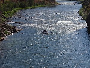
The Middle Fork of the Salmon River has about 300 rapids that rafts can go through! Some of the most famous ones include Dagger Falls, Sulphur Slide, Velvet Falls, and Pistol Creek. Other well-known rapids are Power House, Tappan Falls, Red Side, Weber, Cliffside, Rubber, Hancock, and Devil's Tooth.
Most of these rapids are rated as Class III+ to Class IV on the International scale of river difficulty. This means they are quite challenging and exciting. Dagger Falls is the toughest, rated as a Class V rapid.
Relaxing Hot Springs
The Middle Fork is also famous for its natural hot springs. There are six of them along the first 52 miles (84 km) of the river. These hot springs are popular spots for people to stop and relax.
- Trail Flat hot springs is about 30 yards (27 meters) from the river and has one pool.
- Sheepeater hot springs is about half a mile (0.8 km) from the river. It has three different pools, with temperatures ranging from very hot to just right.
- Sunflower hot springs has five pools. There's even a part where hot water pours off the rocks, creating a natural shower!
- Whitey Cox's hot springs is on a hill with large, sandy-bottom pools. These pools can hold many people.
- Loon Creek hot springs requires a mile-and-a-half (2.4 km) hike along Loon Creek from the Middle Fork. A wooden tub has been built there, offering a nice view of the creek.
- Hospital Bar is a smaller hot spring with two pools. One of them is right next to the river.
Amazing Animals of the Middle Fork
The Middle Fork Salmon River area is home to many different kinds of animals. You might spot some of these if you visit!
Beautiful Plants of the Middle Fork
The area around the Middle Fork also has a wide variety of plants and trees.
|
|
Fish in the River
The clear waters of the Middle Fork are home to several types of fish.
- Cutthroat trout
- Rainbow trout, including steelhead
- Mountain whitefish
- Bull trout
- Chinook salmon
Birds of the Middle Fork
Many different birds can be seen flying around or nesting near the Middle Fork Salmon River.
 | Percy Lavon Julian |
 | Katherine Johnson |
 | George Washington Carver |
 | Annie Easley |


