Lostine River facts for kids
Quick facts for kids Lostine River |
|
|---|---|

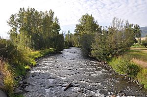
Looking upstream from Route 82 bridge at Lostine
|
|
|
Location of the mouth of Lostine River in Oregon
|
|
| Country | United States |
| State | Oregon |
| County | Wallowa |
| Physical characteristics | |
| Main source | Minam Lake Eagle Cap Wilderness, Wallowa Mountains, Wallowa–Whitman National Forest 7,383 ft (2,250 m) 45°11′08″N 117°21′05″W / 45.18556°N 117.35139°W |
| River mouth | Wallowa River Lostine 3,008 ft (917 m) 45°33′07″N 117°29′26″W / 45.55194°N 117.49056°W |
| Length | 31.4 mi (50.5 km) |
| Type: | Wild, Recreational |
| Designated: | October 28, 1988 |
The Lostine River is a beautiful river in northeastern Oregon, United States. It flows for about 31.4 miles (50.5 km) and eventually joins the Wallowa River. This river helps drain part of the Eagle Cap Wilderness in the Wallowa Mountains, which is inside the Wallowa–Whitman National Forest.
Contents
Lostine River: A Special Place
The Lostine River is so special that in 1988, about 16 miles (26 km) of its upper part were named a "Wild and Scenic River." This means it is protected for its natural beauty and importance.
Wild and Recreational Sections
- About 5 miles (8 km) of the river, starting from its source at Minam Lake, are called "wild." This part is kept very natural and untouched.
- The next 11 miles (18 km) are called "recreational." This section is also protected but allows for more activities like fishing or rafting.
Journey of the Lostine River
The Lostine River begins its journey high up at Minam Lake. This lake is nearly 7,400 feet (2,300 meters) above sea level. It's about 15 miles (24 km) south of the town of Lostine.
River's Path and Landscape
The river generally flows north through a U-shaped valley. This valley was carved out by glaciers long ago. The river leaves the national forest at about 3,930 feet (1,200 meters) elevation. As it flows, the land becomes flatter. It eventually meets the Wallowa River at about 3,000 feet (910 meters) elevation.
How the River's Flow Changes
The amount of water in the Lostine River changes a lot throughout the year. It can be as low as 50 cubic feet per second (1.4 cubic meters per second). But during wetter times, it can reach up to 1,000 cubic feet per second (28 cubic meters per second).
Protecting Lostine River Salmon
For a long time, the Lostine River was home to different types of salmon. These fish were an important food source for the Nez Perce people. However, changes to the river caused problems for the salmon.
Challenges for Salmon
In the 1960s, a type of salmon called Coho salmon disappeared from the river. Another type, the spring Chinook salmon, also faced big challenges. By 1999, their numbers had dropped very low.
Working Together for Salmon
The Nez Perce people started working to help the salmon in the 1990s. Their efforts began to make a difference. By 2005, the number of Chinook salmon had grown to 800 fish.
A Plan for the Future
That same year, farmers, the Nez Perce, and the Oregon Water Trust made an agreement. They decided to work together to keep enough water in the river during summer. This helps the young salmon survive and grow. By 2009, the number of Chinook salmon had increased even more, to over 2,000 fish. This shows how working together can help protect nature.
 | Claudette Colvin |
 | Myrlie Evers-Williams |
 | Alberta Odell Jones |


