
Lamoille, Nevada facts for kids
Quick facts for kids
Lamoille, Nevada
|
|
|---|---|

Lamoille Presbyterian Church with the Ruby Mountains in the background
|
|

Lamoille, Nevada
Location in Nevada
|
|
| Country | United States |
| State | Nevada |
| County | Elko |
| Area | |
| • Total | 1.84 sq mi (4.78 km2) |
| • Land | 1.84 sq mi (4.78 km2) |
| • Water | 0.00 sq mi (0.00 km2) |
| Elevation | 5,925 ft (1,806 m) |
| Population
(2020)
|
|
| • Total | 130 |
| • Density | 70.50/sq mi (27.22/km2) |
| Time zone | UTC-8 (Pacific (PST)) |
| • Summer (DST) | UTC-7 (PDT) |
| ZIP code |
89828
|
| FIPS code | 32-39300 |
| GNIS feature ID | 2583938 |
Lamoille is a small, quiet community in Elko County, located in the northeastern part of Nevada, United States. It's nestled at the base of the beautiful Ruby Mountains. In 2020, about 130 people lived there. Lamoille is about 19 miles (30 km) southeast of the city of Elko. It's known as a "census-designated place," which means it's a specific area identified by the census bureau for statistics, but it's not a city with its own local government.
Contents
History of Lamoille
The history of Lamoille and its surroundings is quite interesting! A nearby highway marker tells us about the early days.
Early Settlers and the California Trail
Long ago, many travelers used the California Trail to head west. This trail followed the Humboldt River. However, the grass along the river became very worn out from all the use. So, many travelers left the main trail near Starr Valley. They would go around the East Humboldt Range and the Ruby Mountains. They followed a path used by the Shoshone Indian people. This path led them to Lamoille Valley, where they could rest their animals. After resting, they would return to the Humboldt River.
In 1865, the first settlers, John Walker and Thomas Waterman, arrived in the area. Waterman named the valley "Lamoille" after his home state, Vermont.
The Crossroads Community
In 1868, John Walker built the Cottonwood Hotel, a store, and a blacksmith shop in the valley. Because of these important services, the settlement became known as "The Crossroads." Travelers could get their wagons fixed and buy food and supplies here. Over time, other buildings like a 20-bedroom hotel, a creamery (for dairy products), a flour mill, and a dance hall were built. Sadly, these original buildings are no longer standing.
Lamoille Today
Today, Lamoille is located near the western side of the Ruby Mountains. It's at the very end of Nevada State Route 227. This makes it the main entrance to the Ruby Mountains, especially through the National Forest Scenic Byway that goes up Lamoille Canyon.
A small church was built in Lamoille in 1907. It's on the east side of the community and is still used today.
Population of Lamoille
| Historical population | |||
|---|---|---|---|
| Census | Pop. | %± | |
| 2020 | 130 | — | |
| U.S. Decennial Census | |||
The population of a place tells us how many people live there. According to the 2020 census, 130 people lived in Lamoille.
Climate in Lamoille
Lamoille has a varied climate, meaning the weather changes a lot throughout the year. It can get quite cold and snowy in winter, and warm in summer.
| Climate data for Lamoille 2N, Nevada, 1991–2020 normals: 5,750 ft (1,750 m) | |||||||||||||
|---|---|---|---|---|---|---|---|---|---|---|---|---|---|
| Month | Jan | Feb | Mar | Apr | May | Jun | Jul | Aug | Sep | Oct | Nov | Dec | Year |
| Record high °F (°C) | 59 (15) |
64 (18) |
76 (24) |
81 (27) |
88 (31) |
93 (34) |
95 (35) |
96 (36) |
93 (34) |
85 (29) |
70 (21) |
62 (17) |
96 (36) |
| Mean maximum °F (°C) | 48 (9) |
53 (12) |
64 (18) |
73 (23) |
79 (26) |
87 (31) |
92 (33) |
90 (32) |
86 (30) |
77 (25) |
65 (18) |
54 (12) |
92 (33) |
| Mean daily maximum °F (°C) | 35.3 (1.8) |
39.4 (4.1) |
47.8 (8.8) |
54.5 (12.5) |
63.3 (17.4) |
73.9 (23.3) |
83.8 (28.8) |
83.0 (28.3) |
74.3 (23.5) |
62.0 (16.7) |
46.8 (8.2) |
36.7 (2.6) |
58.4 (14.7) |
| Daily mean °F (°C) | 22.7 (−5.2) |
25.4 (−3.7) |
33.6 (0.9) |
39.5 (4.2) |
47.9 (8.8) |
56.3 (13.5) |
63.7 (17.6) |
61.7 (16.5) |
53.4 (11.9) |
42.6 (5.9) |
31.4 (−0.3) |
23.6 (−4.7) |
41.8 (5.5) |
| Mean daily minimum °F (°C) | 10.0 (−12.2) |
11.4 (−11.4) |
19.4 (−7.0) |
24.6 (−4.1) |
32.6 (0.3) |
38.7 (3.7) |
43.6 (6.4) |
40.5 (4.7) |
32.5 (0.3) |
23.2 (−4.9) |
15.9 (−8.9) |
10.4 (−12.0) |
25.2 (−3.8) |
| Mean minimum °F (°C) | −12 (−24) |
−10 (−23) |
2 (−17) |
10 (−12) |
20 (−7) |
29 (−2) |
36 (2) |
30 (−1) |
19 (−7) |
9 (−13) |
−3 (−19) |
−11 (−24) |
−19 (−28) |
| Record low °F (°C) | −30 (−34) |
−20 (−29) |
−18 (−28) |
−3 (−19) |
10 (−12) |
23 (−5) |
29 (−2) |
24 (−4) |
13 (−11) |
−6 (−21) |
−22 (−30) |
−24 (−31) |
−30 (−34) |
| Average precipitation inches (mm) | 1.36 (35) |
1.30 (33) |
1.85 (47) |
2.29 (58) |
1.97 (50) |
1.01 (26) |
0.30 (7.6) |
0.48 (12) |
0.87 (22) |
1.14 (29) |
1.12 (28) |
1.19 (30) |
14.88 (377.6) |
| Average snowfall inches (cm) | 15.70 (39.9) |
14.10 (35.8) |
17.70 (45.0) |
10.40 (26.4) |
3.00 (7.6) |
0.20 (0.51) |
0.00 (0.00) |
0.00 (0.00) |
0.20 (0.51) |
1.80 (4.6) |
6.40 (16.3) |
14.90 (37.8) |
84.4 (214.42) |
| Source 1: NOAA | |||||||||||||
| Source 2: XMACIS2 (records) | |||||||||||||
Gallery
-
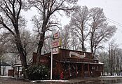
Snow at the Hotel Lamoille
-
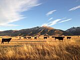
Cattle near Lamoille Canyon Road
-
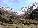
Lamoille Canyon


See also
 In Spanish: Lamoille (Nevada) para niños
