Ibapah, Utah facts for kids
Quick facts for kids
Ibapah
|
|
|---|---|

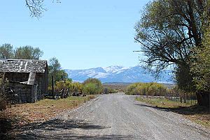
The roadway through Ibapah, September 2007
|
|
| Country | United States |
| State | Utah |
| County | Tooele |
| Settled | 1859 |
| Named for | Goshute Ai-bim-pa "White Clay Water" |
| Elevation | 5,282 ft (1,610 m) |
| Time zone | UTC-7 (Mountain (MST)) |
| • Summer (DST) | UTC-6 (MDT) |
| ZIP code |
84034
|
| Area code(s) | 435 |
| GNIS feature ID | 1437592 |
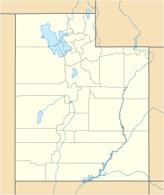
Ibapah (pronounced EYE-buh-pah) is a small community in the far western part of Tooele County, Utah. It is very close to the Nevada state line. Ibapah is an unincorporated community, which means it doesn't have its own local government like a city or town.
What is Ibapah Like?
| Historical population | |||
|---|---|---|---|
| Census | Pop. | %± | |
| 1860 | 6 | — | |
| 1880 | 174 | — | |
| 1890 | 117 | −32.8% | |
| 1900 | 353 | 201.7% | |
| 1910 | 256 | −27.5% | |
| 1920 | 120 | −53.1% | |
| 1930 | 152 | 26.7% | |
| 1940 | 133 | −12.5% | |
| 1950 | 70 | −47.4% | |
| Source: U.S. Census Bureau | |||
Ibapah is located near the Deep Creek Mountains. The area was first settled in 1859. Mormon missionaries came here to teach local Native Americans about farming.
This community was once an important stop. A Pony Express station operated here from 1860 to 1861. The Pony Express was a fast mail service that used horses. Ibapah was also on an early route of the Lincoln Highway, one of the first roads to cross the United States. A post office served the community from 1883 until 1980.
Today, most people living in Ibapah are Goshute people. There are also some farms and a trading post. Ibapah is the main center for the Confederated Tribes of the Goshute Reservation. This is a group of Native Americans officially recognized by the United States government.
The community was first called Deep Creek, named after a nearby creek. Later, its name was changed to Ibapah. This name comes from the Goshute language. The Goshute word Ai-bim-pa or Ai'bĭm-pa means "White Clay Water."
Ibapah is quite isolated. To get there, people often have to drive out of Utah into Nevada, and then back into Utah.
Ibapah's Weather
The weather in Ibapah is typical for a high-elevation area in the Great Basin. It is a semi-arid climate, which means it's quite dry. Because of this, there are often big differences between daytime and nighttime temperatures.
| Climate data for Ibapah, Utah, 1991–2020 normals, 1903–2020 extremes: 5279ft (1609m) | |||||||||||||
|---|---|---|---|---|---|---|---|---|---|---|---|---|---|
| Month | Jan | Feb | Mar | Apr | May | Jun | Jul | Aug | Sep | Oct | Nov | Dec | Year |
| Record high °F (°C) | 68 (20) |
75 (24) |
82 (28) |
89 (32) |
98 (37) |
105 (41) |
111 (44) |
108 (42) |
102 (39) |
94 (34) |
80 (27) |
73 (23) |
111 (44) |
| Mean maximum °F (°C) | 58.6 (14.8) |
63.6 (17.6) |
74.6 (23.7) |
80.8 (27.1) |
88.9 (31.6) |
96.5 (35.8) |
102.2 (39.0) |
100.4 (38.0) |
94.5 (34.7) |
84.5 (29.2) |
71.3 (21.8) |
60.4 (15.8) |
103.0 (39.4) |
| Mean daily maximum °F (°C) | 45.0 (7.2) |
49.1 (9.5) |
58.3 (14.6) |
64.1 (17.8) |
73.2 (22.9) |
84.9 (29.4) |
94.2 (34.6) |
92.8 (33.8) |
82.9 (28.3) |
69.0 (20.6) |
54.7 (12.6) |
44.7 (7.1) |
67.7 (19.9) |
| Daily mean °F (°C) | 28.7 (−1.8) |
32.9 (0.5) |
40.8 (4.9) |
46.2 (7.9) |
54.1 (12.3) |
63.0 (17.2) |
71.0 (21.7) |
69.2 (20.7) |
60.0 (15.6) |
48.2 (9.0) |
36.7 (2.6) |
28.4 (−2.0) |
48.3 (9.0) |
| Mean daily minimum °F (°C) | 12.4 (−10.9) |
16.8 (−8.4) |
23.3 (−4.8) |
28.3 (−2.1) |
35.0 (1.7) |
41.2 (5.1) |
47.9 (8.8) |
45.5 (7.5) |
37.1 (2.8) |
27.4 (−2.6) |
18.8 (−7.3) |
12.0 (−11.1) |
28.8 (−1.8) |
| Mean minimum °F (°C) | −8.8 (−22.7) |
−3.6 (−19.8) |
9.5 (−12.5) |
16.7 (−8.5) |
21.5 (−5.8) |
29.6 (−1.3) |
37.0 (2.8) |
34.3 (1.3) |
22.8 (−5.1) |
12.2 (−11.0) |
1.5 (−16.9) |
−7.5 (−21.9) |
−13.9 (−25.5) |
| Record low °F (°C) | −39 (−39) |
−32 (−36) |
−17 (−27) |
2 (−17) |
8 (−13) |
20 (−7) |
23 (−5) |
21 (−6) |
10 (−12) |
−5 (−21) |
−18 (−28) |
−38 (−39) |
−39 (−39) |
| Average precipitation inches (mm) | 0.79 (20) |
0.87 (22) |
1.09 (28) |
1.44 (37) |
1.41 (36) |
0.90 (23) |
0.71 (18) |
0.77 (20) |
0.68 (17) |
0.69 (18) |
0.54 (14) |
0.63 (16) |
10.52 (269) |
| Average snowfall inches (cm) | 6.10 (15.5) |
6.70 (17.0) |
4.20 (10.7) |
1.80 (4.6) |
0.00 (0.00) |
0.00 (0.00) |
0.00 (0.00) |
0.00 (0.00) |
0.00 (0.00) |
0.60 (1.5) |
3.80 (9.7) |
6.70 (17.0) |
29.9 (76) |
| Source 1: NOAA | |||||||||||||
| Source 2: XMACIS2 (records & 1991-2020 monthly max/mins) | |||||||||||||
 | Mary Eliza Mahoney |
 | Susie King Taylor |
 | Ida Gray |
 | Eliza Ann Grier |


