
Wendover, Utah facts for kids
Quick facts for kids
Wendover, Utah
|
|
|---|---|

|
|

Location in Tooele County and the state of Utah
|
|

Location of Utah in the United States
|
|
| Country | United States |
| State | Utah |
| County | Tooele |
| Founded | 1908 |
| Named for | "Wending over" the desert |
| Area | |
| • Total | 8.93 sq mi (23.12 km2) |
| • Land | 8.93 sq mi (23.12 km2) |
| • Water | 0.00 sq mi (0.00 km2) |
| Elevation | 4,226 ft (1,288 m) |
| Population
(2020)
|
|
| • Total | 1,115 |
| • Density | 166.80/sq mi (64.40/km2) |
| Time zone | UTC−7 (Mountain (MST)) |
| • Summer (DST) | UTC-6 (MDT) |
| ZIP Code |
84083
|
| Area code(s) | 435 |
| FIPS code | 49-82730 |
| GNIS feature ID | 2412214 |
Wendover is a small city located on the western edge of Tooele County, Utah, in the United States. In 2020, about 1,115 people lived there. It's known for being right on the border with another city, West Wendover, in Nevada.
Contents
Where is Wendover Located?
Wendover is right on Utah's western border. It sits next to West Wendover, Nevada. The two cities are so close they almost look like one big town.
Interstate 80, a major highway, runs just north of both cities. Another road, Interstate 80 Business, goes right through the middle of them. The old Wendover Cut-off used to be a main road connecting Wendover to other places. Now, it's a smaller road used by local traffic.
A Look at Wendover's Past
Wendover started as a stop for trains in 1908. This was when the Western Pacific Railroad was being built.
Connecting the Country by Phone
A very important event happened here in 1914. Workers finished the first phone line that stretched across the entire United States! This line was about 3,400 miles long. The first phone call across the country was made on January 25, 1915. This call helped celebrate the opening of a big fair called the Panama Pacific Exposition.
Railroads and Air Bases
From 1917 to 1939, another railroad, the Deep Creek Railroad, also operated in Wendover. Later, in 1983, the Western Pacific Railroad became part of the larger Union Pacific Railroad.

During World War II, the area near Wendover was very important. The Wendover Army Air Field was a training base for pilots who flew bomber planes. This included the crew of the Enola Gay. The Enola Gay was a famous plane that stayed at this base until June 1945.
In 2008, the Utah Department of Transportation made improvements to the highway near Wendover. There are also plans to fix up the Wendover Airport. This airport is located at the old Wendover Air Force Base.
Joining Two Cities?
People have talked about joining Wendover, Utah, with West Wendover, Nevada. West Wendover has casinos and gambling, which is not allowed in Utah. For the cities to join, both the U.S. Congress and the states of Nevada and Utah would need to agree. In 2002, the U.S. House of Representatives voted to let Wendover join Nevada. However, the idea did not become a law.
Who Lives in Wendover?
Here's how the population of Wendover has changed over the years:
| Historical population | |||
|---|---|---|---|
| Census | Pop. | %± | |
| 1920 | 180 | — | |
| 1930 | 205 | 13.9% | |
| 1940 | 272 | 32.7% | |
| 1950 | 814 | 199.3% | |
| 1960 | 609 | −25.2% | |
| 1970 | 781 | 28.2% | |
| 1980 | 1,099 | 40.7% | |
| 1990 | 1,127 | 2.5% | |
| 2000 | 1,537 | 36.4% | |
| 2010 | 1,400 | −8.9% | |
| 2020 | 1,115 | −20.4% | |
| U.S. Decennial Census | |||
According to the census from 2000, there were 1,537 people living in Wendover. Many families had children under 18 living with them. The average household had about 3 to 4 people.
The population was quite young, with many people under 18 years old. The average age in the city was 24 years.
What is Wendover's Geography Like?
Wendover covers about 6.4 square miles (16.7 square kilometers) of land. There is no water area within the city limits.
If you look at the hillside north of the city, you can see a large letter W. This is a famous landmark for the area.
What is the Climate Like?
Wendover has a cool desert climate. This means it has hot summers and cold, freezing winters. The temperature can change a lot between day and night.
Wendover is one of the driest places in the Great Basin. It gets very little rain, only about 4.58 inches (116 mm) each year. It also gets very little snow, only about 5.5 inches (14 cm) per year. This is much less snow than other nearby cities.
| Climate data for West Wendover Air Force Base | |||||||||||||
|---|---|---|---|---|---|---|---|---|---|---|---|---|---|
| Month | Jan | Feb | Mar | Apr | May | Jun | Jul | Aug | Sep | Oct | Nov | Dec | Year |
| Record high °F (°C) | 64 (18) |
80 (27) |
81 (27) |
92 (33) |
103 (39) |
105 (41) |
112 (44) |
110 (43) |
103 (39) |
90 (32) |
78 (26) |
65 (18) |
112 (44) |
| Mean daily maximum °F (°C) | 35.8 (2.1) |
42.9 (6.1) |
53.1 (11.7) |
62.5 (16.9) |
72.7 (22.6) |
82.9 (28.3) |
92.5 (33.6) |
89.9 (32.2) |
78.9 (26.1) |
63.7 (17.6) |
47.6 (8.7) |
37.0 (2.8) |
63.3 (17.4) |
| Mean daily minimum °F (°C) | 18.7 (−7.4) |
24.4 (−4.2) |
32.0 (0.0) |
40.1 (4.5) |
49.4 (9.7) |
58.4 (14.7) |
67.0 (19.4) |
64.4 (18.0) |
53.3 (11.8) |
41.3 (5.2) |
28.9 (−1.7) |
20.5 (−6.4) |
41.5 (5.3) |
| Record low °F (°C) | −16 (−27) |
−12 (−24) |
8 (−13) |
19 (−7) |
26 (−3) |
31 (−1) |
43 (6) |
36 (2) |
28 (−2) |
18 (−8) |
5 (−15) |
−18 (−28) |
−18 (−28) |
| Average precipitation inches (mm) | 0.28 (7.1) |
0.28 (7.1) |
0.37 (9.4) |
0.48 (12) |
0.72 (18) |
0.51 (13) |
0.25 (6.4) |
0.34 (8.6) |
0.34 (8.6) |
0.47 (12) |
0.29 (7.4) |
0.25 (6.4) |
4.58 (116) |
| Average snowfall inches (cm) | 1.6 (4.1) |
1.4 (3.6) |
0.5 (1.3) |
0.2 (0.51) |
0.0 (0.0) |
0.0 (0.0) |
0.0 (0.0) |
0.0 (0.0) |
0.0 (0.0) |
0.1 (0.25) |
0.4 (1.0) |
1.3 (3.3) |
5.5 (14.06) |
Schools in Wendover
The Tooele County School District runs Anna Smith Elementary School, which serves the children in the Wendover area.
Years ago, when people talked about Wendover joining Nevada, some worried it would affect school funding. At that time, Wendover did not have its own elementary school, and residents really wanted one.
Images for kids
-
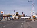
Border between Wendover, Utah and West Wendover, Nevada, March 2006
-
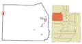
Location in Tooele County and the state of Utah
-
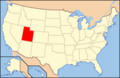
Location of Utah in the United States
See also
 In Spanish: Wendover (Utah) para niños
