
Cedar Mountains (Tooele County, Utah) facts for kids
Quick facts for kids Cedar Mountains |
|
|---|---|

View southeast of Skull Valley & Stansbury Mountains from Cedar Mountain Wilderness
|
|
| Highest point | |
| Peak | Tabbys Peak |
| Elevation | 6,921 ft (2,110 m) |
| Dimensions | |
| Length | 45 mi (72 km) N-S, (north 30-mi section) |
| Width | 5 mi (8.0 km) (widest, 7-mi, SE trending for south 15-mi section) |
| Geography | |

Location in Utah
|
|
| Country | United States |
| Communities | Dugway, Aragonite, Low and Delle |
| Range coordinates | 40°33′49″N 112°58′53″W / 40.56355°N 112.98137°W |
The Cedar Mountains are a long mountain range in Tooele County, Utah, in the USA. This range stretches for about 45 miles (72 km). It sits on the eastern edge of the Great Salt Lake Desert.
The Cedar Mountains are home to the Cedar Mountain Wilderness. They are located between Skull Valley to the east and the vast Great Salt Lake Desert to the west.
Contents
Exploring the Cedar Mountains
The Cedar Mountains have two main parts. The northern part is about 30 miles (48 km) long and runs straight north. The southern part is about 15 miles (24 km) long and turns towards the southeast.
Mountain Heights and Springs
The mountains in the north are moderately high, reaching over 6,000 feet. In the southeast, they are a bit lower, around 5,000 feet. You can find many natural springs at the base of these mountains.
Passes Through the Mountains
There are three important mountain passes that cut through the Cedar Mountains. A pass is like a low spot or gap in a mountain range, making it easier to travel through.
- Hastings Pass and North Cedar Loop Road help you reach the very northern part of the range.
- Rydalch Pass and Canyon are about 4 miles north of the southeastern section.
- Six Horse Pass is right in the middle of the range. You can get to it using unpaved roads from the west side, near the salt flats of the Great Salt Lake Desert.
Highest Points and Central Areas
The highest point in the Cedar Mountains is Tabbys Peak. It stands tall at 6,921 feet (2,109 meters). This peak is located just north of Rydalch Pass. Another notable spot is White Rock, which is 5,693 feet (1,735 meters) high. It's found in the middle of the southeastern mountain section.
The very center of the entire Cedar Mountains range is close to Quiney Spring, on the western side.
Getting to the Cedar Mountains
It's fun to explore the Cedar Mountains! Here's how you can get there:
Accessing the North
You can reach the northern part of the Cedar Mountains from Interstate 80.
If you're coming from Aragonite, you can take Hastings Pass Road. From there, Cedar Mountain Road follows the western edge of the mountains south to West Cedar Flats Road. South Valley Road from Skull Valley also connects after crossing Rydalch Pass and Rydalch Canyon.
Accessing the South
The southern 15-mile section of the mountains can be reached from Dugway and the southern part of Skull Valley.
- Take Utah State Route 196 north from Dugway.
- S. Cedar Mountain Road follows the northeastern foothills of the range.
- Post Hollow Road also exits west from Utah 196.
Images for kids
-
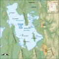
A map showing the Lakeside Mountains, the northern Cedar Mountains, and northern Skull Valley.

