
Lakeside Mountains facts for kids
Quick facts for kids Lakeside Mountains |
|
|---|---|

2 sections of the Lakeside Mountains
(2003, dramatic low lake level) |
|
| Highest point | |
| Peak | Craner Peak ((southeast section)-Lakeside Mountains-(~8 mi from south terminus)) |
| Elevation | 6,625 ft (2,019 m) |
| Dimensions | |
| Length | 34 mi (55 km) 13 mi north-trending section, 21 mi southeast section |
| Width | 4 mi (6.4 km) (~6 to 4 mi in southeast section), 4 mi in north |
| Geography | |

Location in Utah
|
|
| Country | United States |
| Communities | Lakeside, Delle, (Timpie) and (Low) |
| Range coordinates | 40°58′33″N 112°51′52″W / 40.975767°N 112.86442°W |
The Lakeside Mountains are a long chain of hills and peaks in Utah, United States. They stretch for about 55 kilometers (34 miles). You can find them on the southwest side of the Great Salt Lake. These mountains are located in parts of Tooele County and Box Elder County.
This mountain range has two main parts. One part goes north for about 21 kilometers (13 miles). The other part goes southeast and has peaks of different heights. It also includes the highest point of the whole range.
The northern end of the mountains is near the town of Lakeside, Utah. This area is also on the eastern edge of the Great Salt Lake Desert.
Contents
Exploring the Lakeside Mountains
The Lakeside Mountains have a straight shape, with two main sections. The northern part of the range goes slightly north-northeast. The southern part of this section is a mountain area with Sally Mountain, which is 1,785 meters (5,855 feet) tall.
North of Sally Mountain, the range changes into long, narrow ridges and small valleys that run side-by-side.
The Southern Section
The southern part of the Lakeside Mountains goes directly southeast. A small, low area called a saddle separates the northern and southern sections. A hill named Richins Knoll, which is 1,337 meters (4,387 feet) high, is right next to this saddle.
As you go southeast from there, the mountains start to rise. The first big peak is Jedediah Mountain, standing at 1,779 meters (5,837 feet). About 5 kilometers (3 miles) southeast of Jedediah Mountain is the highest point of the entire range: Craner Peak. This impressive peak reaches 2,020 meters (6,625 feet) into the sky.
Getting to the Mountains
You can reach the southern end of the Lakeside Mountains by using Interstate 80. This major highway crosses the range near the town of Delle.
From Delle, Interstate 80 goes northwest, following the base of the mountains. It then enters the northern part of the Cedar Mountains. After that, the highway turns west and goes through the Great Salt Lake Desert.
If you're coming from the northern Cedar Mountains, you can take Puddle Valley Highway. This improved road goes straight north through Puddle Valley. It then reaches the western side of the northern Lakeside Mountains.
There's a small valley called "Death Valley" in a hilly area on the eastern edge of the Great Salt Lake Desert. About 1.6 kilometers (1 mile) east of it is Death Ridge, which is a smaller ridge. The very northern end of the mountains near Lakeside has several named features, each about 1.6 kilometers (1 mile) apart: Scad Ridge, Sedal Valley, Cave Ridge, and the shoreline of the Great Salt Lake.
Images for kids
-
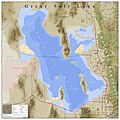
Great Salt Lake and named landforms
-
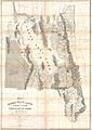
An 1852 map of Utah and the Great Salt Lake


