
Parleys Canyon facts for kids
Quick facts for kids Parleys Canyon |
|
|---|---|

The mouth of Parleys Canyon, facing East.
|
|
| Traversed by | |
| Location | Salt Lake / Summit counties, Utah, United States |
| Range | Wasatch Mountains |
| Coordinates | 40°42′43″N 111°47′53″W / 40.71194°N 111.79806°W |
Parleys Canyon is a famous canyon in Utah, United States. It's a key route through the Wasatch Mountains. The main highway, Interstate 80 (I-80), travels right through it. Before I-80, other important roads like the Lincoln Highway and U.S. Route 40 also used this path.
At the very top of the canyon is a high point called Parleys Summit. This summit is 7,120 feet (2,170 meters) high. It's the highest spot on I-80 in Utah! Both the canyon and the summit are named after Parley P. Pratt. He was an early settler in the Salt Lake Valley. He helped find a better way to travel through the mountains. Before his route, people used a harder path through Emigration Canyon.
Exploring Parleys Canyon
Parleys Canyon starts where I-215 joins I-80 in Salt Lake City. It stretches all the way to Parleys Summit. The first part of the canyon is quite winding and narrow. Workers even had to use dynamite to make space for the wide I-80 highway.
Even though it's narrow, the highway stays wide, with six or more lanes. In many spots, it's built right over Parleys Creek. There's also a project to extend the Parley's Trail here. This trail is for walking and biking, making it easier for people to enjoy the canyon without a car.
The canyon gets much wider near Mountain Dell Dam. Here, Utah State Route 65 (SR-65) branches off from the freeway. SR-65 leads to Morgan County. It also connects to a road that goes over to Emigration Canyon. This is near where the historic Mormon Trail once crossed. You can also see Little Dell Reservoir higher up on the side of the canyon.
As the freeway turns east again, there's an exit for Lambs Canyon. This is a smaller canyon that connects to Parleys Canyon. The area around Parleys Summit is known as Summit Park. However, many people call it Jeremy Ranch or Parleys Summit.
In 2018, a special wildlife overpass was built here. It cost $5 million and helps animals cross I-80 safely. The overpass is 50 feet wide and 320 feet long. Fences guide animals to use this safe crossing. The canyon is wide enough here for communities to grow along the freeway. After the summit, the freeway goes into the Snyderville Basin. This is where the popular resort town of Park City is located. You can also find the ski jump from the 2002 Winter Olympics and a large shopping area called Kimball Junction.
The History of Parleys Canyon
Parleys Canyon got its name from Parley P. Pratt. He was given the job of exploring this canyon, which was then called Big Canyon. His task was to build a toll road through it. This road was named the Golden Pass Toll Road.
Construction on the road began in 1848 and finished in 1850. The new road through Parleys Canyon quickly became the main way to get into the Salt Lake Valley. It was much better than the older route through Emigration Canyon.
A narrow-gauge railroad line also used the canyon. This line, owned by the Denver & Rio Grande Western Railroad, went from Salt Lake to Park City. However, the steep hills made it hard for this line to compete. Another railroad, the Union Pacific, had an easier route. Because of this, the D&RG line was eventually stopped. You can still see parts of the old D&RG line today. Some of its old cuts are now used by local roads.
Images for kids
-
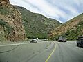
View along Interstate 80 eastbound in Parleys Canyon
-
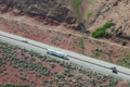
Parleys Canyon, facing Northwest
-
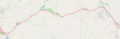
Map of Parleys Canyon, from I215 & I-80 to Kimball Junction
-
Statue of Parley P. Pratt facing Parleys Canyon at dawn


