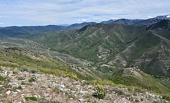
Emigration Canyon, Utah facts for kids
Quick facts for kids
Emigration Canyon, Utah
|
|
|---|---|
|
City
|
|
| Founded | 1846 |
| Given Township Status | 8 January 1997 |
| Incorporated as a Metro Township | 2017 |
| Incorporated as a City | 2024 |
| Area | |
| • Total | 18.22 sq mi (47.19 km2) |
| • Land | 18.22 sq mi (47.19 km2) |
| • Water | 0.00 sq mi (0.00 km2) |
| Population
(2020)
|
|
| • Total | 1,466 |
| • Density | 80.46/sq mi (31.066/km2) |
| ZIP code |
84108
|
| Area code(s) | 385 and 801 |
| FIPS code | 49-22875 |
| Website | https://www.ecmetro.org/ |
|
Emigration Canyon
|
|

Emigration Canyon 2020
|
|
| Location | Salt Lake County, Utah, USA |
|---|---|
| Area | 25 acres (10 ha) (landmarked area) |
| Built | 1847 |
| NRHP reference No. | 66000737 |
| Significant dates | |
| Added to NRHP | October 15, 1966 |
| Designated NHL | January 20, 1961 |
Emigration Canyon is a city and a beautiful canyon in Salt Lake County, Utah, United States. It is located east of Salt Lake City within the Wasatch Range mountains. The canyon starts near the University of Utah. It stretches east and northeast, connecting Salt Lake City with Morgan County. Not all of the canyon is part of the city, as some areas are within Salt Lake City itself. In 2020, about 1,466 people lived here.
A part of Emigration Canyon is a National Historic Landmark. This means it's a very important place in American history. It was recognized in 1961 because of its role in the Mormon pioneers' journey in the 1800s.
Contents
History of Emigration Canyon
Emigration Canyon played a big part in early Utah history. It was the main path used by pioneers entering the area. The Donner Party used this route in 1846. A year later, in 1847, the Mormon Pioneers also entered the Salt Lake Valley through this canyon.
As Brigham Young looked over the canyon, he famously said, "This is the right place. Drive on." These words are well-known in Utah history. Today, this event is remembered at This Is The Place Heritage Park. This park is located at the mouth of the canyon. You can find several historic markers throughout Emigration Canyon. These markers show where the Mormon Pioneers camped and passed on their way to the Salt Lake Valley. One example is a place called Lost Creek Camp.
The area of Emigration Canyon officially became a township on January 8, 1997. In 2015, the people living there voted to become a "metro township." Then, in May 2024, Emigration Canyon and all other metro townships became official cities.
Fun Places to Visit
Emigration Canyon is home to some interesting spots. The Hogle Zoo, which is Salt Lake City's main zoo, is at the mouth of the canyon. However, the zoo is actually within Salt Lake City's borders.
The canyon also has Camp Kostopulos. This camp was started in 1967 by the Kostopulos Dream Foundation. It's a special summer camp for children, teens, and adults with disabilities. Right next to the camp is Ruth's Diner, a famous restaurant that opened in 1930.
Cycling in the Canyon
Emigration Canyon is a very popular place for cycling. It's one of the easiest canyons to ride from Salt Lake City. The ride is about 7.7 miles long. It has an average uphill slope of 5 percent. This means cyclists gain about 1,300 feet in height from the start to the top. Cyclists often call the top "Little Mountain."
There is a good shoulder along the road for bikes. Local drivers are used to seeing many cyclists. You can find restrooms at both the bottom and the top of the canyon. However, these restrooms might be closed during the winter months.
Protecting the Land
A large part of Emigration Canyon is protected. It is within the Uinta-Wasatch-Cache National Forest. Because the canyon is so close to Salt Lake City, some unprotected areas have attracted property developers. Since 2001, the Utah Open Lands Conservation Association has worked to save these lands. By 2016, they had raised money to protect over 260 acres of land in the canyon. This helps keep the canyon natural and beautiful.
See also
 In Spanish: Emigration Canyon (Utah) para niños
 | Laphonza Butler |
 | Daisy Bates |
 | Elizabeth Piper Ensley |


