Great Salt Lake effect facts for kids
The Great Salt Lake effect is a special way the Great Salt Lake in Utah, United States, affects the weather nearby. It's a small but noticeable influence, especially when it comes to snowstorms. These storms are very common in the area and bring a lot of snow, which is important for people and businesses. The Great Salt Lake never freezes, and it can warm up quickly. This allows for what's called "lake-enhanced precipitation" from September all the way through May. These lake-enhanced snowstorms are often why people say Utah has "The Greatest Snow on Earth."
Contents
How the Great Salt Lake Makes Snow
Lake-effect snow around the Great Salt Lake forms in a similar way to other places in the world. However, the Great Salt Lake mainly helps by lifting the air and making the atmosphere unstable. This encourages convection, which is when warm air rises. This is different from the Great Lakes, where the lakes add a lot of moisture and warmth to the air.
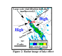
Great Salt Lake enhanced precipitation happens when strong, cold winds from the northwest blow over the lake, which is warmer. This often occurs after a cold front passes, making the air much colder than the lake. When the wind from the land blows towards the lake, it creates a convergence zone. This zone helps guide the cold air over the center of the lake, making the precipitation even stronger.
The saltiness of the Great Salt Lake keeps it from freezing. However, it also means less moisture and warmth are added to the air moving over the lake. So, the lake doesn't add much moisture. The tall Wasatch mountains nearby then catch this lake-enhanced snow. They can get many feet of snow just from this lake effect!
When Does This Snow Happen?
The number of these special snow events changes each year, depending on the large-scale weather patterns. On average, there are about 4 to 5 clear lake-effect snow events each year, plus a similar number of smaller ones. More than half of the clear events last between 13 and 24 hours.
A study in 2000 found that most of these events happened between October and February, with a few in September, April, or May. However, a bigger study in 2012 looked at many more cases. It found that the most active times were actually in the fall (mid-October to mid-December) and spring (early April). There was a quieter period between these two peaks. That same study found an average of 13 events per year, counting both clear and less clear ones.
Most of the clear events leave 8 in|cm or more of snow. In some cases, they can bring over 40 in|cm of snow along a specific path.
Predicting Lake-Effect Snow
Forecasting these snowstorms has gotten much better recently. This is thanks to improved tools like the NEXRAD weather radar system. To make an accurate forecast, scientists need to identify the key things needed for lake-effect precipitation. The main requirements are air that's ready to rise and form clouds easily, enough moisture, and something to lift the air. Many different factors play a role in these requirements.
Thanks to a lot of research and field experiments, our understanding of lake-effect snowstorms has greatly improved. Forecasters have developed many general rules to help predict when, where, and how much lake-effect snow will fall.
Tips for Forecasters
Local weather forecasters have developed a set of rules to help predict lake-enhanced snow:
- A strong northwesterly wind flow brings the most snow to the Salt Lake Valley.
- There needs to be at least a 29 °F (16 °C) temperature difference between the ground and a certain height in the atmosphere (around 10,000 feet or 3,000 meters up). This difference is needed, but it doesn't always guarantee lake-effect snow.
- If there's a stable layer of air below about 10,000 feet (3,000 meters), lake-effect snow has never happened.
- Lake-effect snow can happen at the same time as larger, widespread storm systems.
- A big temperature difference between the lake and the land helps air currents meet over the lake.
- Lake-effect snow usually starts at night. This is when winds from the land meet over the lake, and air rises mostly over the lake.
- During the daytime, lake-effect precipitation often stops. This is because the sun warms the land, causing scattered clouds and rising air over the land instead of just the lake.
- The winds at about 10,000 feet (3,000 meters) usually decide where the snow will fall.
- When winds don't change much in direction or speed as you go higher, it tends to produce heavier snow events.
- The Great Salt Lake adds very little moisture. So, moisture coming from other areas upstream is very important.


