
Mount Timpanogos facts for kids
Quick facts for kids Mount Timpanogos |
|
|---|---|

Mt. Timpanogos from Provo
|
|
| Highest point | |
| Elevation | 11,753 ft (3,582 m) NAVD 88 |
| Prominence | 5,269 ft (1,606 m) |
| Listing |
|
| Geography | |

Mount Timpanogos
Location in Utah
|
|
| Location | Utah County, Utah, U.S. |
| Parent range | Wasatch Range |
| Topo map | USGS Timpanogos |
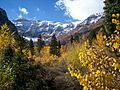
Mount Timpanogos, often called Timp, is a very tall mountain in Utah. It is the second highest mountain in Utah's Wasatch Range. Timpanogos stands about 11,752 ft (3,582 m) above sea level. You can find it in the Uinta-Wasatch-Cache National Forest.
This huge mountain rises about 7,000 ft (2,100 m) above Utah Valley. Many cities like Provo and Orem are in this valley. The mountain's visible parts are made of limestone and dolomite. These rocks are about 300 million years old! In winter, the mountain gets a lot of snow. Snowslides, called avalanches, are common here.
Mount Timpanogos is also home to Timpanogos Cave National Monument. This is a series of beautiful caves inside the mountain. You can take guided tours of these caves during the warmer months. The name "Timpanogos" comes from the Timpanogots tribe. They lived in the valleys around the mountain starting in the 1400s. The name means "rock" (tumpi-) and "water mouth" or "canyon" (panogos).
Contents
What is Mount Timpanogos?
Mount Timpanogos is a famous peak in Utah. It is known for its height and beautiful views. Many people visit it each year for outdoor activities.
Where is Mount Timpanogos located?
Mount Timpanogos is located in Utah County, Utah. It is part of the Wasatch Range, a mountain chain in the western United States. The mountain is a big landmark for the cities in Utah Valley.
How old is Mount Timpanogos?
The rocks you see on Mount Timpanogos are very old. They are mostly limestone and dolomite. These rocks formed from ancient ocean sediments about 300 million years ago. Over time, these layers were pushed up to form the mountain.
How Glaciers Shaped Timpanogos
.jpg)
Mount Timpanogos shows many signs of glaciers. Long ago, during the Ice Age, huge sheets of ice covered the peak. These glaciers carved the mountain into its sharp ridges and U-shaped valleys.
What is the Timpanogos Glacier?
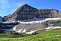
A small part of these old glaciers remains today. It's called the Timpanogos Glacier. This glacier is mostly covered by rocks. It usually has patches of snow all year. Before the 1930s, you could see glacial ice on the surface. Now, it's mostly hidden underground.
In 1994, a large crack opened up. This showed that there is still a glacier buried under the rocks. Sometimes, you can even hear water flowing beneath the rocks. Emerald Lake, a small lake nearby, often looks blue. This color suggests the glacier might still be moving slowly. This unique ice is a leftover from a colder time. Hikers often slide down its snowfield to get down the mountain faster.
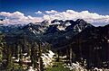
Hiking and Exploring Mount Timpanogos


Mount Timpanogos is one of Utah's most popular places for hiking and climbing. People climb it all year round. Climbing in winter needs special skills and gear. In spring, streams can melt snow from underneath. This creates dangerous holes where climbers can fall.
What are the main hiking trails?
The hike to the top is about 14-mile (23 km) round-trip. You gain almost 5,300 feet (1,600 m) in height. Even with this challenge, many people reach the summit. There are two main trails to the top. One starts at Aspen Grove. The other starts at the Timpooneke campground in American Fork Canyon. Both trails are about the same length.
What will you see on the trails?
As you hike, you will pass through different types of areas. You'll see forests, subalpine areas, and alpine zones. The trails feature waterfalls, conifer trees, rocky slopes, and ridges. You might even spot mountain goats! There's also a small lake called Emerald Lake at 10,380 feet (3,164 m). A short side trip can take you to a B-25 bomber crash site from 1955.


What was the "Timp Hike"?
Before 1970, there was a yearly event called the "Timp Hike." Thousands of people would climb the mountain on one day. This event happened from 1911 to 1970, usually in July. It led to things like a stone shelter near Emerald Lake. There was also a small metal shack on the summit. However, the hike caused damage to the mountain's environment. So, it was stopped to help protect the delicate ecosystem. In 1984, the mountain became a wilderness area. This means it is protected from development.
Geology of Mount Timpanogos

The rocks that make up Mount Timpanogos are mainly limestone. This limestone formed from sediment that settled on an ancient seafloor. This happened over millions of years during the Carboniferous Period, about 300 million years ago.
How did the mountain form?
After the limestone formed, it was lifted high above sea level. The mountain itself grew taller as the valley next to it sank. This process is called basin and range faulting. More recently, glaciers and water shaped the mountain into what we see today.
Safety on Mount Timpanogos
Since 1982, a group called the Timpanogos Emergency Response Team ("TERT") has been on the mountain. They are there on weekends to help hikers. They provide first aid, rescue, and communication.
What are the dangers on the mountain?
The Timpanogos Glacier is one of the main causes of injuries for hikers. Some people try to slide down the snowfield quickly. They might use a shovel to help them slide. However, there can be rocks hidden under the snow. Sliding can cause serious injuries. Many people have needed helicopter rescues because of this activity. The TERT team has helped reduce the number of these rescues.

Folklore of Mount Timpanogos
In the early 1900s, a professor named Eugene Lusk "Timp" Roberts started an annual hike and show. He wanted to share the beauty of Timpanogos with the world. He created his own version of local folklore.
What is the legend of Utahna?
Some people think the ridgeline of Mount Timpanogos looks like a sleeping woman. Roberts wrote a folk tale about a maiden named Utahna. In his story, Utahna made a sacrifice to her gods. One version of this tale was even used for a ballet.

Images for kids
-
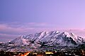
Mt. Timpanogos from Provo
-
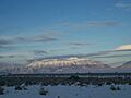
Mount Timpanogos is visible from much of Utah County.
-
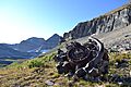
Radial Engine from a 1955 B-25 crash site. The Mount Timpanogos peak is in the background.
-
View of Mount Timpanogos from Timpooneke trail
-
East side of Timpanogos as seen from the Alpine Loop.
-
The east side of Timpanogos as seen from Silver Glance Lake.
-

The location of future Mount Timpanogos situated beneath a shallow sea on a map of the United States during the Carboniferous period
-

Full 360° panorama from the top of Mount Timpanogos on 25 July 2005
-

Panorama of Mount Timpanogos as seen from Lindon, Utah.
See also
 In Spanish: Monte Timpanogos para niños
