
Timpanogos Glacier facts for kids
Quick facts for kids Timpanogos Glacier |
|
|---|---|

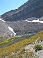
Emerald Lake below the glacier (the bulge in the talus is where the glacier is buried), August 2007
|
|

Timpanogos Glacier
Location in Utah
|
|
| Type | Rock glacier |
| Location | Utah County, Utah United States |
| Coordinates | 40°23′23.53″N 111°38′25.00″W / 40.3898694°N 111.6402778°W |
| Thickness | >100 ft (30 m) |
| Terminus | proglacial lake |
| Status | Unknown |
The Timpanogos Glacier is a special type of glacier called a rock glacier. It is found on Mount Timpanogos in the Wasatch Range mountains in Utah, United States. This glacier is located within the Mount Timpanogos Wilderness, which is part of the Uinta-Wasatch-Cache National Forest. It is the last known glacier in the state of Utah.
Contents
What is the Timpanogos Glacier?

The Timpanogos Glacier sits on the north side of Mount Timpanogos, a mountain that is about 11,749 feet or 3,581 metres tall. Long ago, in the early 1900s, this was a "true" glacier. True glaciers are huge bodies of ice that move slowly and have deep cracks called crevasses.
However, during a very dry period in the 1930s, much of the ice on the surface melted away. Now, the Timpanogos Glacier is mostly ice hidden under a layer of rocks. This is why it is called a rock glacier.
Hidden Ice and Deep Cracks
Even though the ice is mostly covered by rocks, there have been times when it has shown itself. In 1994, some of the rocks moved apart, revealing a crevasse or a channel where water flows under the ice. One person who saw it said the ice was at least 40 feet [12 m] thick.
Later, in the late 1990s or early 2000s, another crevasse reportedly opened up. Someone dropped a stone into it and estimated it was over 100 feet (30 m) deep. Around this time, scientists from Brigham Young University dug down a few feet to reach the ice. They tried to take a sample of the ice to study it, but it was difficult to get a clean sample.
How the Glacier Moves Today
Today, the rock glacier is made up of three parts, or "flow lobes."
- The main part might not be moving anymore.
- The highest part is probably still active and slowly moving.
- The part in the middle is likely no longer moving.
On September 3, 2016, a person who studies rocks found a pit in the highest part of the glacier. This pit was filled with cloudy water from the melting ice. He dug through the rocks and found blue ice about three feet (0.91 m) down. This blue ice had bubbles in it, which is a sign that it was part of the original glacier.
Emerald Lake and the Glacier
Emerald Lake is a small lake located at the bottom of the area where the Timpanogos Glacier used to be much larger. This lake was formed by the glacier. Sometimes, Emerald Lake looks blue. This blue color is a clue that there is still glacial ice hidden nearby. In 2016, the lake did not turn blue, even though water levels were low. This might mean that the main part of the glacier, which touches the lake, is not active anymore.
Images for kids
-
Emerald Lake below the glacier (the bulge in the talus is where the glacier is buried), August 2007
See also
 In Spanish: Glaciar Timpanogos para niños
