Nephi, Utah facts for kids
Quick facts for kids
Nephi, Utah
|
|
|---|---|

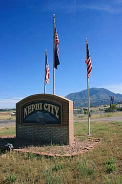
City sign
|
|

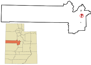
Location in Juab County and state of Utah
|
|
| Country | United States |
| State | Utah |
| County | Juab |
| Settled | 1851 |
| Named for | Nephi |
| Area | |
| • Total | 4.75 sq mi (12.31 km2) |
| • Land | 4.75 sq mi (12.31 km2) |
| • Water | 0.00 sq mi (0.00 km2) |
| Elevation | 5,128 ft (1,563 m) |
| Population
(2020)
|
|
| • Total | 6,443 |
| • Density | 1,356.42/sq mi (523.4/km2) |
| Time zone | UTC−7 (Mountain (MST)) |
| • Summer (DST) | UTC−6 (MDT) |
| ZIP code |
84648
|
| Area code(s) | 435 |
| FIPS code | 49-54220 |
| GNIS feature ID | 1443793 |
Nephi (pronounced NEE-fy) is a city in Juab County, Utah, United States. It is part of the larger Provo–Orem metropolitan area. In 2020, about 6,443 people lived there. Nephi is the main city, or 'county seat,' of Juab County.
Pioneers settled it in 1851, calling it Salt Creek. The city got its current name, Nephi, in 1882. It is the most important city in the Juab Valley, which is a farming area. Nephi was named after a person called Nephi, son of Lehi, from the Book of Mormon.
Contents
History of Nephi
Before people settled here, the area near Salt Creek was a popular camping spot. It was along the Old Mormon Road that led to Southern California. Mormon settlers started a community here in 1851. They named it after the creek, calling it Salt Creek. The town kept that name until 1882. That's when the town and its post office officially became known as Nephi.
Nephi's Population Over Time
| Historical population | |||
|---|---|---|---|
| Census | Pop. | %± | |
| 1860 | 672 | — | |
| 1870 | 1,286 | 91.4% | |
| 1880 | 1,797 | 39.7% | |
| 1890 | 2,034 | 13.2% | |
| 1900 | 2,203 | 8.3% | |
| 1910 | 2,759 | 25.2% | |
| 1920 | 2,603 | −5.7% | |
| 1930 | 2,573 | −1.2% | |
| 1940 | 2,835 | 10.2% | |
| 1950 | 2,990 | 5.5% | |
| 1960 | 2,566 | −14.2% | |
| 1970 | 2,699 | 5.2% | |
| 1980 | 3,285 | 21.7% | |
| 1990 | 3,515 | 7.0% | |
| 2000 | 4,733 | 34.7% | |
| 2010 | 5,389 | 13.9% | |
| 2020 | 6,443 | 19.6% | |
| U.S. Decennial Census | |||
In 2000, there were 4,733 people living in Nephi. There were 1,430 households, and 1,149 of these were families. The city had about 1,134 people per square mile.
Most people in Nephi were White (about 97%). A small number were Hispanic or Latino (about 2.5%).
Many households (50.1%) had children under 18 living with them. Most families (71.1%) were married couples. The average household had 3.24 people. The average family had 3.72 people.
The population was quite young. About 37.8% of residents were under 18 years old. The average age in the city was 28 years.
Geography and Location
Nephi is in the eastern part of Juab County. It sits in the Juab Valley. This valley is located between the Wasatch and San Pitch Mountains to the east. To the west are the lower West Hills and Long Ridge.
Interstate 15 runs along the eastern side of the city. You can get onto I-15 from Exits 222, 225, and 228. I-15 goes north about 31 miles to Spanish Fork. It goes south about 37 miles to Scipio.
Utah State Route 28, which is Nephi's Main Street, goes north 3 miles to I-15. It goes south 41 miles to Gunnison. Utah State Route 132 crosses Main Street in the center of town. It leads southeast 22 miles to Moroni. It also goes southwest 28 miles to Leamington.
The U.S. Census Bureau says that Nephi covers about 4.75 square miles (12.31 square kilometers). All of this area is land.
Nephi's Climate
Nephi has a climate that can be described as either humid subtropical climate or humid continental climate. This depends on how you look at the climate system.
| Climate data for Nephi, Utah (1981–2010) | |||||||||||||
|---|---|---|---|---|---|---|---|---|---|---|---|---|---|
| Month | Jan | Feb | Mar | Apr | May | Jun | Jul | Aug | Sep | Oct | Nov | Dec | Year |
| Mean daily maximum °F (°C) | 39.6 (4.2) |
44.6 (7.0) |
55.6 (13.1) |
64.0 (17.8) |
73.6 (23.1) |
83.9 (28.8) |
91.8 (33.2) |
89.8 (32.1) |
80.5 (26.9) |
66.8 (19.3) |
51.4 (10.8) |
39.5 (4.2) |
65.1 (18.4) |
| Mean daily minimum °F (°C) | 18.2 (−7.7) |
21.5 (−5.8) |
28.5 (−1.9) |
34.3 (1.3) |
42.3 (5.7) |
50.1 (10.1) |
58.7 (14.8) |
57.5 (14.2) |
48.1 (8.9) |
36.9 (2.7) |
26.9 (−2.8) |
18.5 (−7.5) |
36.8 (2.7) |
| Average precipitation inches (mm) | 1.31 (33) |
1.32 (34) |
1.61 (41) |
1.66 (42) |
1.61 (41) |
0.98 (25) |
0.75 (19) |
0.90 (23) |
1.19 (30) |
1.57 (40) |
1.24 (31) |
1.30 (33) |
15.46 (393) |
| Average snowfall inches (cm) | 12.2 (31) |
10.4 (26) |
6.6 (17) |
2.7 (6.9) |
0.4 (1.0) |
0.0 (0.0) |
0.0 (0.0) |
0.0 (0.0) |
0.0 (0.0) |
1.2 (3.0) |
6.9 (18) |
12.9 (33) |
53.4 (136) |
| Source: NOAA | |||||||||||||
Education in Nephi
Nephi is part of the Juab School District. This district manages the public schools in the area.
Notable People from Nephi
- Roger Boisjoly was an engineer. He tried to stop the Space Shuttle Challenger from launching. He spent his last years living in Nephi.
- Brandon Flowers is the lead singer of the band The Killers. He lived in Nephi from age 8 until his junior year at Juab High School. The band's album Pressure Machine is about life in Nephi. It even includes interviews with people from the town.
- Alfred McCune was a railroad builder and mine operator. He moved to Nephi during his life.
See also
 In Spanish: Nephi (Utah) para niños
 | Janet Taylor Pickett |
 | Synthia Saint James |
 | Howardena Pindell |
 | Faith Ringgold |

